
Skyscan Forecast Saturday, January 16, 2016 Chris Parks

Podcast: Play in new window | Download (629.4KB)
Subscribe: RSS
The National Weather Service in Des Moines says hazardous weather will impact Iowa, this weekend. One-to three-inches of snow and blowing snow are expected across much of the state, with two-to three-inches in parts of northwest and western Iowa. The snow is forecast to impact travel Saturday night.
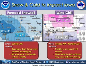 Roadways will likely become snow covered and slippery. Blowing snow may greatly reduce visibility at times. Travel speeds will likely be decreased. And, with cold temperatures, road treatments will not be as effective.
You should also be prepared for extremely cold wind chills of -25 to -40 degrees, especially Sunday morning through Monday morning. Northern Iowa will experience the lowest wind chill values of -35 to -45. As wind chills approach -30 degrees, Frostbite can occur in as little as 10 minutes.
Children and the elderly are especially susceptible to frostbite. Bring pets indoors, if possible. Dress in layers and try to cover as much exposed skin as possible.
(8-a.m. News)
Today: Mostly Cloudy w/flurries. Nearly steady temp in the 20’s. NW @ 15-25.
Tonight: P/Cldy to Cldy w/scattered flurries. Low 7. NW @ 10-20.
Tomorrow: P/Cldy to Cldy. High 13.
Tom. Night: Cldy w/snow and patchy blowing snow. Low -6.
Sunday: P/Cldy w/areas of light snow early. High 2.
Sun. Night: Mostly Clear. Low -11.
Monday: P/Cldy. High 12.
Thursday’s High in Atlantic was 46. The 24-hour Low ending at 7-a.m. today was 23. Last year on this date we reached 45 for a High and 157 was the low. The All-time Record High in Atlantic on this date was 61 in 1990, while the Record Low was -23 in 1905.
EARLY THIS MORNING…CLOUDY…BREEZY. ISOLATED FLURRIES. NORTHWEST WIND 15 TO 20 MPH.
TODAY…CLOUDY UNTIL LATE AFTERNOON THEN BECOMING PARTLY SUNNY. BREEZY. MUCH COLDER. ISOLATED FLURRIES IN THE MORNING. HIGH IN THE MID 20S. NORTHWEST WIND 15 TO 20 MPH WITH GUSTS TO AROUND 30 MPH.
TONIGHT…PARTLY CLOUDY IN THE EVENING THEN BECOMING MOSTLY CLOUDY. COLDER. LOW 5 TO 10 ABOVE. NORTHWEST WIND 10 TO 15 MPH.
SATURDAY…PARTLY SUNNY. COLDER. HIGH AROUND 15. NORTHWEST WIND AROUND 10 MPH.
SATURDAY NIGHT…SNOW LIKELY. PATCHY BLOWING SNOW AFTER MIDNIGHT. COLDER. LIGHT SNOW ACCUMULATIONS POSSIBLE. LOW 5 TO 10 BELOW. NORTH WIND 5 TO 15 MPH. CHANCE OF SNOW 70 PERCENT. LOWEST WIND CHILL READINGS 15 TO 20 BELOW AFTER MIDNIGHT.
SUNDAY…MOSTLY SUNNY. COLDER. HIGH NEAR ZERO. NORTHWEST WIND 10 TO 15 MPH. WIND CHILL READINGS 20 BELOW TO 30 BELOW ZERO.
SUNDAY NIGHT…MOSTLY CLEAR. LOW AROUND 10 BELOW.
MARTIN LUTHER KING JR DAY…PARTLY SUNNY. HIGH AROUND 10.
331 AM CST THU JAN 14 2016
EARLY THIS MORNING…PARTLY CLOUDY. NOT AS COLD. SOUTHWEST WIND 5 TO 15 MPH.
TODAY…MOSTLY SUNNY. HIGH IN THE MID 40S. SOUTHWEST WIND 10 TO 15 MPH.
TONIGHT…PARTLY CLOUDY THROUGH MIDNIGHT…THEN MOSTLY CLOUDY WITH A 20 PERCENT CHANCE OF LIGHT SNOW AFTER MIDNIGHT. LOW IN THE MID 20S. NORTHWEST WIND 5 TO 15 MPH. GUSTS UP TO 25 MPH AFTER MIDNIGHT.
FRIDAY…CLOUDY…BREEZY…COLDER. HIGH IN THE MID 20S. NORTHWEST WIND 15 TO 20 MPH WITH GUSTS TO AROUND 30 MPH.
SATURDAY…MOSTLY CLOUDY. COLDER. HIGH 10 TO 15. NORTHWEST WIND 10 TO 15 MPH.
SATURDAY NIGHT…CLOUDY WITH A 40 PERCENT CHANCE OF LIGHT SNOW. COLDER. LOW 5 TO 10 BELOW.
SUNDAY…MOSTLY SUNNY. COLDER. HIGH ZERO TO 5 ABOVE.
Today: Partly Cloudy w/flurries possible this morning. High 35. SW @ 10-15.
Tonight: P/Cldy. Low 23. SW @ 5-10.
Tomorrow: P/Cldy. High around 43. W/SW @ 10-20
Tomorrow Night: P/Cldy to Cldy. Low 27.
Friday: P/Cldy to Cldy w/light snow or flurries possible in the morning. High 30.
Saturday: Mo. Cldy w/flurries. High 13.
Tuesday’s daytime High in Atlantic was 10. The temps rose overnight, so our 24-Hour High was 20. Our 24-hour Low ending at 7-a.m. today was 1. Last year on this date we reached 25 for a High and -10 was the low. The All-time Record High in Atlantic on this date was 62 in 1987, while the Record Low was -24 in 1916.
EARLY THIS MORNING…MOSTLY CLOUDY. SOUTH WIND 10 TO 15 MPH WITH GUSTS TO AROUND 25 MPH.
TODAY…MOSTLY SUNNY. MUCH WARMER. HIGH IN THE UPPER 30S. SOUTHWEST WIND 10 TO 15 MPH. GUSTS UP TO 25 MPH IN THE MORNING.
TONIGHT…PARTLY CLOUDY. NOT AS COLD. LOW IN THE UPPER 20S. SOUTHWEST WIND 5 TO 10 MPH.
THURSDAY…SUNNY. HIGH IN THE MID 40S. SOUTHWEST WIND 5 TO 15 MPH.
THURSDAY NIGHT…PARTLY CLOUDY THROUGH MIDNIGHT THEN BECOMING MOSTLY CLOUDY. LOW IN THE UPPER 20S. NORTHWEST WIND 5 TO 15 MPH. GUSTS UP TO 25 MPH AFTER MIDNIGHT.
FRIDAY…CLOUDY. A 20 PERCENT CHANCE OF LIGHT SNOW IN THE MORNING. BREEZY…COLDER. HIGH IN THE UPPER 20S. NORTHWEST WIND 15 TO 20 MPH WITH GUSTS TO AROUND 30 MPH.
SATURDAY…PARTLY SUNNY. COLDER. HIGH AROUND 15.
Today: Partly Cloudy. High 12. NW-W @ 10-20, diminishing late.
Tonight: Mostly cloudy. Low of 2 w/temps rising overnight into the upper teens. SE @ 5-10.
Wednesday: P/Cldy to Cldy w/flurries possible. High around 32. S/SW @ 10-15.
Wed. Night: P/Cldy. A nearly steady temperature around 28.
Thursday: P/Cldy. High near 42. Southwest wind 5 to 10 mph.
Friday: Mo. Cldy & windy, w/a 30% chance of light snow or flurries. High near 30.
Monday’s High in Atlantic was 33. Our 24-hour Low ending at 7-a.m. today was 2. Last year on this date we reached 17 for a High and -10 was the low. The All-time Record High in Atlantic on this date was 57 in 1961 & 1987, while the Record Low was
-27 in 1974.
Early This Morning: Partly cloudy. Breezy. Northwest wind 15 to 25 mph.
Today: Mostly sunny. Very cold. Breezy. High 10 to 15. Northwest wind 5 to 20 mph. Gusts up to 30 mph in the morning.
Tonight: Partly cloudy in the evening then becoming mostly cloudy. Low around 10. South wind 5 to 10 mph.
Wednesday: Mostly sunny. Much warmer. High in the mid 30s. West wind 5 to 10 mph.
Wednesday Night: Partly cloudy through midnight then becoming mostly cloudy. Not as cold. Low in the mid 20s. Southwest wind 5 to 10 mph.
Thursday: Sunny. High in the lower 40s. Southwest wind 5 to 15 mph.
Friday: Cloudy with a 30 percent chance of snow. Breezy…colder. High in the upper 20s.
Today: Partly Cloudy to Cloudy. High 25. Light snow or flurries. W @ 10-15.
Tonight: Mostly Cldy w/scattered light snow or flurries. Low 5. N @ 10-20.
Tomorrow: P/Cldy. High 12. NW @ 10-20.
Tom. Night: Mo. Cldy w/temps rising into the mid-teens.
Wednesday: P/Cldy to Cldy. High around 28.
Thursday: P/Cldy. High near 40.
Our 24-hour in Atlantic ending at 7-a.m. today was 14 (Sunday’s actual daytime High was 11). Our 24-hour ending at 7-a.m. today, was -8. Last year on this date we reached 39 for a High and 7 was the low. The All-time Record High in Atlantic on this date was 55 in 1986, while the Record Low was -22 in 1892.


