
342 AM CST FRI JAN 1 2016
EARLY THIS MORNING…MOSTLY CLEAR. WEST WIND AROUND 10 MPH.
TODAY…SUNNY. HIGH IN THE LOWER 30S. WEST WIND 10 TO 15 MPH.
TONIGHT…CLEAR. LOW AROUND 10. WEST WIND 5 TO 15 MPH.
SATURDAY…SUNNY. HIGH IN THE MID 30S. WEST WIND 5 TO 10 MPH.
SATURDAY NIGHT…CLEAR. LOW 10 TO 15. NORTHWEST WIND 5 TO 10 MPH.
SUNDAY…SUNNY. HIGH IN THE UPPER 20S. NORTH WIND 5 TO 10 MPH.
MONDAY…MOSTLY SUNNY. HIGH IN THE LOWER 20S.
TUESDAY…PARTLY SUNNY. HIGH IN THE UPPER 20S.
Today: Mostly sunny, with a high near 24. W/NW @ 10-15.Wind chills around -5.
Tonight: Partly cloudy, with a low around 5. W/NW @ 10-20.Wind chill as low as -5.
New Year’s Day: P/Cldy. High near 30. W @ 10-20. Wind chill values as low as -5.
Friday Night: Clear, with a low around 11.
Sat./Sun:: P/Cldy. Highs both days around 30. W @ 5-10.
Wednesday’s High in Atlantic was 25. Our 24-hour ending at 7-a.m. today, was 1. We received a .1” of snow over the past 24-hours. Last year on this date we reached 20 for a High and -3 was the low. The All-time Record High in Atlantic on this date was 60 in 1891, while the Record Low was -18 in 1976.
2015 will rank among the wettest in the 143 years that Iowa weather records have been kept. There are still a few hours left in the year and State Climatologist Harry Hillaker is close to having all the calculations done. “Probably the seventh wettest year, with precipitation averaging about eight inches greater than what’s usual,” Hillaker says. “Normal’s about 35 inches and we’ve had a little over 43.25 inches of precipitation averaged over the state.”
There may be “one or two locations” in northeast Iowa that end up recording ever-so-slightly below-normal precipitation for the year. “On the other extreme, it looks like Bedford in Taylor County, southwest Iowa, looks to have had over 63 inches of precipitation this year, which would easily be a record for that location,” Hillaker says. “It’s not a statewide record, but extremely wet year in that part of southwest Iowa.”
There were several locations in southwest, western and and south central Iowa where precipitation for the year was above 50 inches. March was the seventh DRIEST March on the record in Iowa, but May, June, July, August and September all were above normal. “Then November and December, at the end of the year, way above normal,” Hillaker says. “Just generally speaking, a rather wet year.” The summer was “relatively cool” but 2015 will wind up as slightly warmer than normal year.
“A very warm end to the year,” Hillaker says. “September, October, November, December — all of the last four years — were all none of them quite records although December was kind of on a near-record pace for much of the month, but here in the last week or so December’s been much more seasonal and it’s pulling down that monthly average.”
Tornado season lasted a bit longer than normal. A handful of tornadoes struck Iowa on October 23rd, but didn’t do much damage. Hillaker says there’s still not a final tally for the number of actual tornadoes that struck Iowa on November 11th. “There were probably at least 15 tornadoes on Veterans Day,” Hillaker says, “and some of those were rather strong ones, especially across southern parts of the state.” The number of tornadoes reported during 2015 will be close to the yearly average, according to Hillaker, somewhere between 50 and 55 twisters.
(Radio Iowa)
401 AM CST THU DEC 31 2015
EARLY THIS MORNING…MOSTLY CLEAR. COLDER. WEST WIND AROUND 5 MPH.
TODAY…MOSTLY SUNNY. HIGH IN THE LOWER 20S. WEST WIND 5 TO 10 MPH.
TONIGHT…PARTLY CLOUDY. LOW AROUND 10. WEST WIND 5 TO 10 MPH.
NEW YEARS DAY…SUNNY. HIGH IN THE UPPER 20S. WEST WIND 10 TO 15 MPH.
SATURDAY…SUNNY. HIGH IN THE LOWER 30S. WEST WIND 5 TO 10 MPH.
SUNDAY…SUNNY. HIGH IN THE UPPER 20S.
Today: Mostly Cloudy w/snow likely before 10-am, then scattered flurries. 1” or less accumulation is expected. High near 25. W/NW @ 10-20.
Tonight: Gradually becoming partly cloudy. Low around 10. W/NW @ 5-10. Wind chill values as low as zero.
Tomorrow: Partly cloudy. High around 21. W/SW @ 10-15.
New Year’s Eve: Partly cloudy, with a low around 9. W/NEW @ 5-10.
New Year’s Day: Clear to P/Cldy. High near 25.
Friday Night: Clear, with a low around 13.
Saturday: P/Cldy. High near 30.
Tuesday’s High in Atlantic was 24. Our 24-hour ending at 7-a.m. today, was 12. We received .3” of snow overnight and until 7-a.m. That amounted to just .04” precipitation.
Last year on this date we reached 11 for a High and -4 was the low. The All-time Record High in Atlantic on this date was 64 in 2004, while the Record Low was -22 in 1917.
The National Weather Service says a fast moving weather system will produce periods of light snow this morning. Snowfall amounts will range from a dusting to around one inch. The morning commute will likely be impacted with roads become snow covered and slippery. Just before 6-a.m., the Iowa Dept. of Transportation’s map at 511ia.org showed most roads in southwest Iowa between Highway 92 and Highway 44, were partially covered with snow. South of Highway 92, roads were mostly covered with snow. The snowfall should move east of the area by around noon.
Otherwise expect mostly cloudy conditions the remainder of the afternoon with highs in the 20s. Mostly cloudy and cold conditions are expected on Thursday although it should be dry. Quiet but cold conditions are expected on New Year’s Eve with lows in the single digits north to the lower teens south. Expect some sunshine on New Year’s Day with seasonal temperatures in the 20s.
Early This Morning: Light snow. Little or no new snow accumulation. West wind near 5 mph. Chance of snow 80 percent.
Today: Cloudy. Light snow likely through mid morning…then scattered flurries before noon. Little or no snow accumulation. High in the mid 20s. West wind 5 to 10 mph. Chance of snow 70 percent.
Tonight: Mostly cloudy. Low 5 to 10 above. West wind 5 to 10 mph.
Thursday: Mostly sunny. High in the lower 20s. West wind 5 to 10 mph.
Thursday Night: Partly cloudy. Low 5 to 10 above. West wind 5 to 10 mph.
New Years Day: Sunny. High in the mid 20s. West wind 10 to 15 mph.
Friday Night: Mostly clear. Low 10 to 15.
Saturday: Sunny. High in the upper 20s.
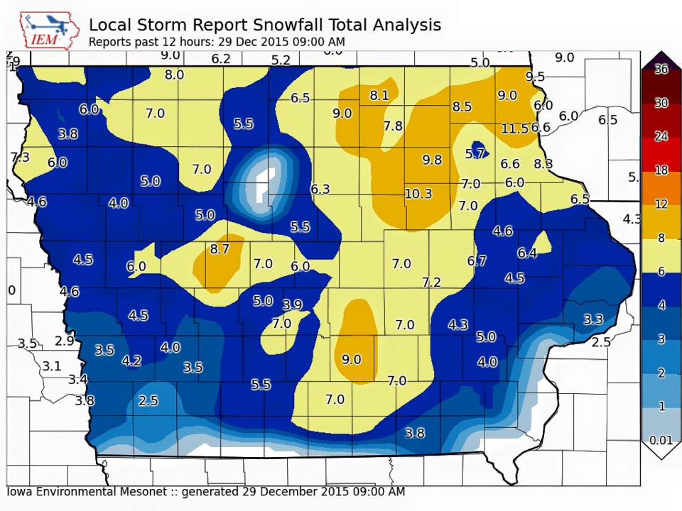
The National Weather Service today (Tuesday) released a graphic on their Facebook page showing the latest report on snowfall totals from Monday. The report was compiled as of 9-a.m. today. Some areas in north central Iowa remain blank because there were insufficient reports to the NWS to complete the image (Click on the graphic below to enlarge)…
Today: Mostly Cloudy, with flurries. High near 22. NW @ 10-20. Wind chill values as low as 5.
Tonight: Mo. Cldy w/a 40% chance of snow, mainly between midnight and 5am. Low around 13. N-NW @ 10-15. New snow accumulation of less than a half inch possible.
Wednesday: Cloudy w/a 20% chance of snow before noon. High near 24. W/NW @ 10-15.Wind chill values as low as 10.
Wednesday Night: Cloudy to P/Cldy. Low around 7. Wind chill values as low as zero.
Thursday: Partly Cloudy. High near 20. West wind 5 to 10 mph.
Thursday Night: Partly cloudy, with a low around 7.
New Year’s Day: P/Cldy. High near 22.
Monday’s High in Atlantic was 23. Our 24-hour ending at 7-a.m. today, was 17. We received 3.8-inches of snow yesterday, for a storm total of 4-inches at KJAN. The 3.8 inches of snow melted into just .16” of liquid precipitation. Last year on this date we reached 23 for a High and -1 was the low. The All-time Record High in Atlantic on this date was 60 in 1984, while the Record Low was -22 in 1917.
EARLY THIS MORNING…CLOUDY. NORTHWEST WIND AROUND 10 MPH.
TODAY…CLOUDY. HIGH IN THE LOWER 20S. NORTHWEST WIND 5 TO 10 MPH.
TONIGHT…CLOUDY. LOW AROUND 15. NORTHWEST WIND NEAR 5 MPH.
WEDNESDAY…CLOUDY. HIGH IN THE LOWER 20S. WEST WIND 5 TO 10 MPH.
WEDNESDAY NIGHT…MOSTLY CLOUDY. LOW 5 TO 10 ABOVE. WEST WIND 5 TO 10 MPH.
THURSDAY…PARTLY SUNNY. HIGH 15 TO 20. WEST WIND 5 TO 10 MPH.
THURSDAY NIGHT…MOSTLY CLOUDY. LOW 5 TO 10 ABOVE.
NEW YEARS DAY…MOSTLY SUNNY. HIGH IN THE LOWER 20S


