
There are several reports of vehicles in the ditches, median and minor collisions this afternoon in the KJAN listening area. Most of the accidents appear to be happening along Interstate 80 in Cass and Adair Counties. The Iowa DOT’s road conditions website at 511ia.org shows roads in and around Atlantic are partially covered with snow, ice and slush. I-80 from about Highway 173 in Cass County to Highway 25 in Adair County is also slushy. Slow down, and allow extra travel time to reach your destination.
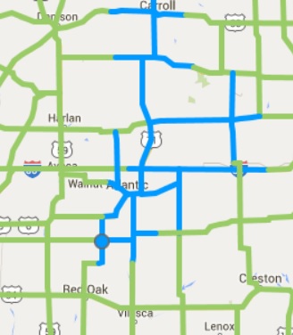
Roads in blue are partially covered in snow and slush. Bridges and overpasses may be icy. (Image as of 2:30-p.m. 12/23)
Today: Cloudy w/rain becoming mixed with & changing to snow this afternoon. High (early) in the Low 40’s w/temps falling into the mid-30’s. NW @ 10-20mph w/gusts to near 30 at times.
Tonight: Cloudy w/mixed precip ending. Low 28. NW @ 10-20. Total New snow accumulation of around 1” is possible.
Thursday: Mo. Cldy w/flurries in the morning. High 35. NW @ 10-20.
Thursday Night: Partly cloudy, with a low around 27.
Christmas Day: Mo. Cldy. High around 40.
Friday Night: A 60% chance of rain or drizzle. Low around 33.
Saturday: Mo. Cldy w/a 40% chance of rain and/or snow. High 44
Tuesday’s High in Atlantic was 44. Our 24-hour ending at 7-a.m. today, was 28. We received .24” of precipitation overnight through 7-a.m. today. Last year on this date we reached 36 for a High and 32 was the low. The All-time Record High in Atlantic on this date was 62 in 1964, while the Record Low was -22 in 1983.
Early This Morning: Rain. Not as cool. Southeast wind 5 to 10 mph. Chance of rain 90 percent.
Today: Rain in the morning…then a chance of light rain in the afternoon. High in the lower 40s. Northeast wind 5 to 10 mph shifting to the northwest 10 to 15 mph with gusts to around 25 mph in the afternoon. Chance of rain near 100 percent.
Tonight: Partly cloudy through midnight…then mostly cloudy with a 20 percent chance of light snow after midnight. Colder. Low in the upper 20s. West wind 5 to 10 mph.
Thursday: Mostly cloudy. A 20 percent chance of light snow in the morning. High in the mid 30s. West wind 5 to 10 mph.
Thursday Night: Partly cloudy. Low in the upper 20s. South wind around 5 mph.
Christmas Day: Mostly cloudy. A 20 percent chance of light rain in the afternoon. High in the lower 40s. Southeast wind 5 to 15 mph.
Friday Night: Cloudy with a 50 percent chance of rain. Low in the mid 30s.
Saturday: Cloudy with a 30 percent chance of rain. High in the upper 30s.
Today: Areas of dense fog this morning; Mostly Cloudy. High near 46. S @ 10-20.
Tonight: Cloudy w/light rain. Low around 38. S @ 10-15.
Wednesday: Cloudy w/rain in the morning becoming mixed with light snow. High near 40 w/temps slowly declining during the afternoon into the 30’s.
Wednesday Night: Mostly cloudy, with a low around 27.
Thursday: Cloudy to Partly Cloudy w/a chance of flurries. High 35
Christmas Eve: Partly cloudy, with a low around 29.
Christmas Day: A slight chance of rain and snow before noon, then a slight chance of rain. Mostly cloudy, with a high near 44.
Monday’s High in Atlantic was 31. Our 24-hour ending at 7-a.m. today, was 25. We received a trace of precipitation Monday, in the form of drizzle and mist.
Last year on this date we reached 42 for a High and 32 was the low. The All-time Record High in Atlantic on this date was 65 in 1933, while the Record Low was -27 in 1989.
SAC-CRAWFORD-CARROLL-AUDUBON-GUTHRIE-CASS-ADAIR-ADAMS-UNION-TAYLOR-RINGGOLD COUNTIES…
635 AM CST TUE DEC 22 2015
…PATCHY DENSE FOG MAY LEAD TO SLICK ROADS THIS MORNING…
FOG HAS DEVELOPED OVER PORTIONS OF WESTERN AND SOUTHERN IOWA THIS MORNING WITH VISIBILITIES DROPPING TO A QUARTER TO A HALF OF A MILE IN SPOTS. THIS FOG COMBINED WITH SUB FREEZING PAVEMENT
TEMPERATURES MAY LEAD TO SLICK SPOTS ON ROADS THROUGH MID
MORNING…ESPECIALLY ALONG AND NORTH OF INTERSTATE 80. IF YOU
ENCOUNTER ANY FOG…PLEASE LEAVE PLENTY OF SPACE BETWEEN YOU AND THE DRIVER AHEAD OF YOU AND BE PREPARED FOR ANY SLICK AREAS.
EARLY THIS MORNING…CLOUDY. AREAS OF FOG. SOUTH WIND 5 TO 10 MPH.
TODAY…CLOUDY…BREEZY…WARMER. PATCHY FOG THROUGH MID MORNING. HIGH IN THE MID 40S. SOUTH WIND 10 TO 20 MPH WITH GUSTS TO AROUND 30 MPH.
TONIGHT…CLOUDY. NOT AS COOL. A SLIGHT CHANCE OF LIGHT RAIN BEFORE MIDNIGHT. A CHANCE OF LIGHT RAIN AFTER MIDNIGHT…THEN LIGHT RAIN LIKELY EARLY IN THE MORNING. LOW IN THE UPPER 30S. SOUTH WIND 5 TO 15 MPH. CHANCE OF RAIN 70 PERCENT.
WEDNESDAY…MOSTLY CLOUDY. RAIN LIKELY IN THE MORNING…THEN A CHANCE OF RAIN EARLY IN THE AFTERNOON. A SLIGHT CHANCE OF RAIN LATE IN THE AFTERNOON. HIGH IN THE LOWER 40S. NORTHWEST WIND 5 TO 15 MPH. CHANCE OF RAIN 70 PERCENT.
THURSDAY…PARTLY SUNNY. HIGH IN THE UPPER 30S. WEST WIND 5 TO 10 MPH.
CHRISTMAS DAY…CLOUDY. A SLIGHT CHANCE OF RAIN AND SNOW IN THE MORNING…THEN A SLIGHT CHANCE OF RAIN IN THE AFTERNOON. HIGH IN THE LOWER 40S. CHANCE OF PRECIPITATION 20 PERCENT.
Today: Cloudy with patchy fog & Light rain or snow possible this morning. High near 35. NW @ 15-25.
Tonight: Mostly cloudy, with a low around 28. Winds light and variable.
Tomorrow: P/Cldy to Cldy. High 48. S @ 10-20.
Tom. Night: Mo. Cldy & breezy, w/a 30% chance of rain after midnight. Low around 37.
Wednesday: Mo. Cldy w/a chance of showers. High 45.
Thursday: Mo. Cldy w/a chance of flurries. High near 35.
Sunday’s High in Atlantic was 48. Our 24-hour ending at 7-a.m. today, was 30.
Last year on this date we reached 41 for a High and 36 was the low. The All-time Record High in Atlantic on this date was 58 in 1941, while the Record Low was -22 in 1989.
Today: Cloudy…colder. Patchy fog through mid morning. High in the upper 30s. West wind 5 to 15 mph.
Tonight: Mostly cloudy in the evening then becoming partly cloudy. Low in the upper 20s. Southwest wind around 5 mph.
Tuesday: Partly sunny. Breezy. High in the upper 40s. South wind 5 to 15 mph increasing to 15 to 20 mph in the afternoon. Gusts up to 30 mph.
Tuesday Night: Mostly cloudy. A 20 percent chance of rain after midnight. Low in the upper 30s. South wind 5 to 15 mph.
Wednesday: Cloudy with a 30 percent chance of rain. High in the upper 40s.
Wednesday Night: Mostly cloudy with a 20 percent chance of rain and snow. Low in the upper 20s.
Thursday: Partly sunny. High in the lower 40s.
401 AM CST SUN DEC 20 2015
EARLY THIS MORNING…MOSTLY CLOUDY. NOT AS COLD. SOUTH WIND 10 TO 15 MPH.
TODAY…MOSTLY CLOUDY. PATCHY DRIZZLE EARLY IN THE AFTERNOON. A SLIGHT CHANCE OF LIGHT RAIN AND DRIZZLE LATE IN THE AFTERNOON. PATCHY FOG LATE IN THE AFTERNOON. BREEZY…WARMER. HIGH IN THE LOWER 50S. SOUTH WIND 10 TO 20 MPH. CHANCE OF RAIN 20 PERCENT.
TONIGHT…CLOUDY. A 20 PERCENT CHANCE OF LIGHT RAIN UNTIL EARLY MORNING. LOW IN THE UPPER 20S. NORTHWEST WIND 5 TO 15 MPH.
MONDAY…MOSTLY CLOUDY. COLDER. HIGH IN THE MID 30S. WEST WIND 5 TO 15 MPH.
TUESDAY…PARTLY SUNNY. HIGH IN THE MID 40S. SOUTH WIND 5 TO 10 MPH INCREASING TO AROUND 15 MPH IN THE AFTERNOON. GUSTS UP TO 25 MPH.
WEDNESDAY…MOSTLY CLOUDY WITH A 20 PERCENT CHANCE OF LIGHT RAIN. HIGH IN THE UPPER 40S.
Skyscan Forecast Saturday, December 19, 2015 Chris Parks

Podcast: Play in new window | Download (716.6KB)
Subscribe: RSS


