
357 AM CST MON JAN 11 2016
EARLY THIS MORNING…MOSTLY CLOUDY. NOT AS COLD. SOUTH WIND AROUND 5 MPH.
TODAY…MOSTLY CLOUDY. WARMER. SCATTERED FLURRIES IN THE MORNING. HIGH IN THE LOWER 20S. WEST WIND NEAR 10 MPH INCREASING TO 10 TO 15 MPH IN THE AFTERNOON.
TONIGHT…MOSTLY CLOUDY UNTIL EARLY MORNING THEN BECOMING PARTLY CLOUDY. SCATTERED LIGHT SNOW SHOWERS IN THE EVENING…THEN A SLIGHT CHANCE OF LIGHT SNOW SHOWERS BEFORE MIDNIGHT. BREEZY. LOW 5 TO 10 ABOVE. NORTHWEST WIND 10 TO 20 MPH. GUSTS UP TO 30 MPH AFTER MIDNIGHT. CHANCE OF SNOW 20 PERCENT.
TUESDAY…MOSTLY SUNNY. COLDER. HIGH 10 TO 15. NORTHWEST WIND 10 TO 15 MPH WITH GUSTS TO AROUND 25 MPH.
TUESDAY NIGHT…PARTLY CLOUDY THROUGH MIDNIGHT THEN BECOMING MOSTLY CLOUDY. LOW 5 TO 10 ABOVE. SOUTHWEST WIND 5 TO 10 MPH.
WEDNESDAY…PARTLY SUNNY. MUCH WARMER. HIGH IN THE LOWER 30S. SOUTHWEST WIND 5 TO 10 MPH.
THURSDAY…MOSTLY SUNNY. HIGH AROUND 40.
Today: Sunny, with a high near 11. Wind chill values as low as -25. Northwest wind 8 to 10 mph becoming southwest in the afternoon.
Tonight: Mostly cloudy, with a temperature rising to around 13 by 1am. Wind chill values as low as -5. Southwest wind 6 to 8 mph.
Monday: Cloudy, with a high near 24. Wind chill values as low as 5. West wind 6 to 15 mph, with gusts as high as 21 mph.
Monday Night: A 20 percent chance of snow before midnight. Mostly cloudy, with a low around 9. Blustery, with a west wind 9 to 18 mph becoming north northwest after midnight. Winds could gust as high as 25 mph.
Tuesday: Mostly sunny, with a high near 11. Blustery.
Tuesday Night: Partly cloudy, with a low around 4.
Wednesday: Mostly sunny, with a high near 29.
Saturday’s High in Atlantic was 10. Our 24-hour Low ending at 7-a.m. today was -7.
A WIND CHILL ADVISORY REMAINS IN EFFECT UNTIL 10 AM CST THIS MORNING FOR THE STATE OF IOWA AND PARTS OF EASTERN NEBRASKA.
* EXPECT WIND CHILLS TO RANGE FROM 18 BELOW TO 28 BELOW ZERO INTO THE MID MORNING HOURS.
* THE COLD WIND CHILLS WILL CAUSE FROSTBITE IN AS LITTLE AS 30 MINUTES TO EXPOSED SKIN.
PRECAUTIONARY/PREPAREDNESS ACTIONS…
A WIND CHILL ADVISORY MEANS THAT COLD AIR AND THE WIND WILL COMBINE TO GENERATE LOW WIND CHILLS. FROST BITE AND HYPOTHERMIA CAN OCCUR IF PRECAUTIONS ARE NOT TAKEN. MAKE SURE YOU WEAR A HAT AND GLOVES.
THE NATIONAL WEATHER SERVICE HAS EXPANDED A WIND CHILL ADVISORY TO NEARLY ALL OF IOWA’S 99 COUNTIES.
A WIND CHILL ADVISORY IS IN EFFECT FROM LATE TONIGHT THROUGH 10-A.M. SUNDAY.
Wind Chill Advisory for counties in light blue.
NORTHWEST WINDS WILL PERSIST FROM 15 TO 25 MPH WITH GUSTS NEAR 30 MPH. TEMPERATURES WILL DROP TO NEAR ZERO BY SUNDAY MORNING. WIND CHILL VALUES OF NEAR 25 BELOW ZERO WILL OCCUR.
* IMPACTS…FROSTBITE CAN OCCUR WITHIN 30 MINUTES OF EXPOSED SKIN IN THESE TYPES OF WIND CHILL VALUES.
PRECAUTIONARY/PREPAREDNESS ACTIONS…
A WIND CHILL ADVISORY MEANS THAT VERY COLD AIR AND STRONG WINDS
WILL COMBINE TO GENERATE LOW WIND CHILLS. THIS WILL RESULT IN
FROST BITE AND LEAD TO HYPOTHERMIA IF PRECAUTIONS ARE NOT TAKEN. IF YOU MUST VENTURE OUTDOORS…MAKE SURE YOU WEAR A HAT AND GLOVES.
**Wind Chill Advisory tonight thru late Sunday morning for counties along & North of I-80**
Today: Becoming mostly sunny & cold. High 15-20. Wind chill values as low as -10. Blustery, with a north northwest wind 16 to 20 mph, with gusts as high as 28 mph.
Tonight: Mostly clear, with a low around -3. Wind chill values as low as -20. Blustery, with a north northwest wind 11 to 17 mph, with gusts as high as 25 mph.
Sunday: Sunny, with a high near 12. Wind chill values as low as -20. Northwest wind 8 to 10 mph becoming southwest in the afternoon.
Sunday Night: Partly cloudy, with a low around 8. Southwest wind 7 to 9 mph.
Monday: Mostly cloudy, with a high near 25.
Monday Night: Scattered flurries. Mostly cloudy, with a low around 11.
Tuesday: Mostly sunny, with a high near 13. Blustery.
Friday’s High in Atlantic was 33. Our 24-hour ending at 7-a.m. today, was 9. We received .2” of snow, which amounted to just a Trace of precipitation over the past 24-hours. Last year on this date we reached 13 for a High and -9 was the low. The All-time Record High in Atlantic on this date was 58 in 2002, while the Record Low was -23 in 1974.
COUNTIES: MONONA-HARRISON-SHELBY…THE NATIONAL WEATHER SERVICE IN OMAHA/VALLEY HAS ISSUED A WIND CHILL ADVISORY…WHICH IS IN EFFECT FROM 11 PM THIS EVENING TO 9 AM CST SUNDAY.
A WIND CHILL ADVISORY IS ALSO IN EFFECT FOR SAC-CRAWFORD-CARROLL-GREENE-AUDUBON-GUTHRIE AND DALLAS COUNTIES, FROM MIDNIGHT TONIGHT TO 10 AM CST SUNDAY.
* WIND CHILL VALUES…MAINLY FROM 18 BELOW TO 25 BELOW ZERO.
PRECAUTIONARY/PREPAREDNESS ACTIONS…
A WIND CHILL ADVISORY MEANS THAT VERY COLD AIR AND BRISK WINDS WILL COMBINE TO GENERATE LOW WIND CHILLS. THIS WILL RESULT IN FROST BITE AND LEAD TO HYPOTHERMIA IF PRECAUTIONS ARE NOT TAKEN. IF YOU MUST VENTURE OUTDOORS…MAKE SURE YOU WEAR A HAT AND GLOVES.
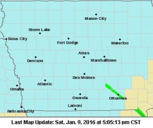
346 AM CST SAT JAN 9 2016
EARLY THIS MORNING: CLOUDY & COLDER. SCATTERED FLURRIES. NORTH WIND 10 TO 15 MPH WITH GUSTS TO AROUND 25 MPH.
TODAY: MOSTLY CLOUDY, BREEZY & COLDER. HIGH AROUND 15. NORTH WIND 15 TO 20 MPH WITH GUSTS TO AROUND 30 MPH.
TONIGHT: MOSTLY CLEAR. BITTERLY COLD & BREEZY. LOW ZERO TO 5 BELOW. NORTHWEST WIND 10 TO 20 MPH. WIND CHILL READINGS 15 TO 20 BELOW.
SUNDAY: SUNNY BUT VERY COLD. HIGH 10 TO 15. WEST WIND 5 TO 10 MPH. LOWEST WIND CHILL READINGS 15 TO 20 BELOW IN THE MORNING.
SUNDAY NIGHT: PARTLY CLOUDY THROUGH MIDNIGHT THEN BECOMING MOSTLY CLOUDY. NOT AS COLD. LOW 5 TO 10 ABOVE. SOUTHWEST WIND 5 TO 10 MPH.
MONDAY: MOSTLY CLOUDY. WARMER. HIGH IN THE MID 20S. WEST WIND 5 TO 15 MPH.
TUESDAY: MOSTLY SUNNY. BREEZY…COLDER. HIGH 10 TO 15.
Travel on Interstate 80 in western Iowa is becoming hazardous this evening. Already two rollover accidents have been reported, one near Shelby at the 34 mile marker eastbound off ramp, the other in Cass County at the 71-mile marker of I-80 westbound. Wiota 1st Responders and Anita Rescue, along with Medivac ambulance were called to the scene at around 6:10-p.m.
Other vehicles have gone off into the median along I-80. No reports of injuries as of 6:18-p.m.
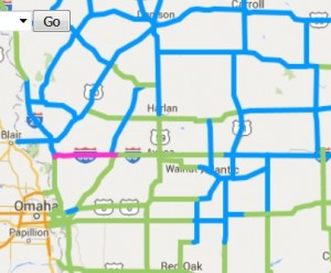
Roads in pink are completely covered in snow, ice or slush. Roads in blue are partially covered.
Today: Areas of fog this morning. Rain and snow mixed through this afternoon becoming all snow, late. High near 34. N @ 10-20. New snow accumulation of less than a half inch possible.
Tonight: Snow likely, mainly before 11pm. Low around 18. N/NW @ 15-25. Wind chill values as low as 5. New snow accumulation of less than a half inch possible.
Saturday: Isolated snow showers before 9am, then scattered flurries after 9am. Temps nearly steady in the teens. N @ 15-30. Wind chill values as low as -10.
Saturday Night: Partly cloudy & windy. Low around -2. N/NW @ 15-30.
Sunday: Sunny and cold, with a high near 13.
Monday: Partly sunny, with a high near 26.
Thursday’s High in Atlantic was 34. Our 24-hour ending at 7-a.m. today, was 32. We received .35” rain/mixed precipitation over the past 24-hours. Last year on this date we reached 27 for a High and 0 was the low. The All-time Record High in Atlantic on this date was 65 in 2003, while the Record Low was -19 in 1970.
EARLY THIS MORNING: LIGHT RAIN AND OCCASIONAL DRIZZLE. AREAS OF FOG. NORTH WIND AROUND 5 MPH. CHANCE OF RAIN 90 PERCENT.
TODAY: CLOUDY. AREAS OF FOG IN THE MORNING. LIGHT RAIN AND DRIZZLE WITH POSSIBLE SNOW IN THE MORNING…THEN A CHANCE OF LIGHT SNOW AND LIGHT RAIN IN THE AFTERNOON. LITTLE OR NO SNOW ACCUMULATION. HIGH IN THE MID 30S. NORTH WIND 5 TO 15 MPH. CHANCE OF PRECIPITATION 90 PERCENT.
TONIGHT: CLOUDY & COLDER. LIGHT SNOW LIKELY THROUGH MIDNIGHT, THEN A CHANCE OF LIGHT SNOW AFTER MIDNIGHT. A SLIGHT CHANCE OF LIGHT SNOW EARLY IN THE MORNING. LITTLE OR NO SNOW ACCUMULATION. LOW 15 TO 20. NORTH WIND AROUND 15 MPH WITH GUSTS TO AROUND 25 MPH. CHANCE OF SNOW 60 PERCENT.
SATURDAY: CLOUDY. ISOLATED SNOW SHOWERS THROUGH MID MORNING, THEN SCATTERED FLURRIES IN THE LATE MORNING AND AFTERNOON. BREEZY. COLDER. HIGH 15 TO 20. NORTH WIND 15 TO 20 MPH WITH GUSTS TO AROUND 30 MPH. CHANCE OF SNOW 20 PERCENT.
SATURDAY NIGHT: CLOUDY TO PARTLY CLOUDY, BREEZY & COLDER. LOW ZERO TO 5 BELOW. NORTHWEST WIND 15 TO 20 MPH WITH GUSTS TO AROUND 30 MPH. WIND CHILL READINGS 15 TO 20 BELOW.
SUNDAY: SUNNY, BREEZY & COLD. HIGH AROUND 10. NORTHWEST WIND 10 TO 15 MPH. GUSTS UP TO 25 MPH IN THE MORNING. LOWEST WIND CHILL READINGS 15 TO 20 BELOW IN THE MORNING.
MONDAY: MOSTLY CLOUDY. WARMER. HIGH IN THE LOWER 20S.


