
EARLY THIS MORNING…CLEAR. NOT AS COLD. WEST WIND 10 TO 15 MPH WITH GUSTS TO AROUND 25 MPH.
TODAY…MOSTLY SUNNY. HIGH IN THE UPPER 30S. NORTHWEST WIND 10 TO 15 MPH WITH GUSTS TO AROUND 25 MPH.
TONIGHT…MOSTLY CLOUDY. LOW IN THE LOWER 20S. NORTHWEST WIND NEAR 10 MPH SHIFTING TO THE SOUTH AFTER MIDNIGHT.
FRIDAY…MOSTLY SUNNY UNTIL LATE AFTERNOON THEN BECOMING MOSTLY CLOUDY. HIGH IN THE MID 40S. SOUTH WIND 10 TO 15 MPH WITH GUSTS TO AROUND 25 MPH.
SATURDAY…MOSTLY CLOUDY. HIGH IN THE MID 40S. SOUTHWEST WIND 5 TO 15 MPH.
SUNDAY…MOSTLY CLOUDY WITH A 20 PERCENT CHANCE OF RAIN. HIGH IN THE LOWER 40S.
Today: Areas of fog before 9am. Otherwise, partly cloudy. High near 37. SW @ 15-20. Wind chill values as low as 5.
Tonight: Partly cloudy, with a low around 25. W/NW @ 10-15.
Tomorrow: P/Cldy. High near 37. W/NW @ 10-15.
Tom. Night: Partly cloudy, with a low around 22.
Friday: P/Cldy. High near 47. S/SW @ 10-20.
Saturday: P/Cldy. High again near 47.
Tuesday’s High in Atlantic was 29. The 24-hour Low ending at 7-a.m. today was 8. Last year on this date we reached 50 for a High and 21 was the low. The All-time Record High in Atlantic on this date was 61 in 1934, while the Record Low was -31 in 1902.
The National Weather Service says while temperatures will moderate through the weekend with highs from the mid 30s to around 50 through Sunday, a strong winter storm is likely next week. A couple of weak disturbances will affect Iowa today and Friday with the main impact being clouds and a slight chance of snow showers.
A strong winter storm is expected to develop over the Southwest U.S. into the Southern Plains then lift into the upper Midwest Tuesday through Wednesday. Officials say while it is too early too accurately assess track and timing, the storm will tap some gulf moisture and pull in a lot of cold air as it lifts Northeast. Moderate to heavy snowfall and strong winds are likely with this system. Watch and listen for updates on this developing storm system.
343 AM CST WED JAN 27 2016
EARLY THIS MORNING…PARTLY CLOUDY. AREAS OF FOG. SOUTHWEST WIND NEAR 5 MPH.
TODAY…MOSTLY SUNNY. PATCHY FOG THROUGH MID MORNING. HIGH IN THE UPPER 30S. SOUTHWEST WIND 5 TO 15 MPH WITH GUSTS TO AROUND 25 MPH.
TONIGHT…PARTLY CLOUDY. NOT AS COLD. LOW IN THE MID 20S. WEST WIND 10 TO 15 MPH.
THURSDAY…SUNNY. HIGH IN THE UPPER 30S. NORTHWEST WIND 10 TO 15 MPH.
FRIDAY…MOSTLY SUNNY. HIGH IN THE MID 40S. SOUTH WIND 10 TO 15 MPH.
SATURDAY…PARTLY SUNNY. HIGH IN THE MID 40S.
Today: Cloudy this morning; Partly Cloudy this afternoon. High around 30. NW @ 10-20. Tonight: P/Cldy. Winds light & variable. Low 10.
Tomorrow: Areas of fog possible early; P/Cldy. High 37. SW @ 15-30.
Thursday: P/Cldy. High around 37.
Friday: P/Cldy. High near 45.
Monday’s High in Atlantic was 29. We received .4” of snow Monday, along with freezing drizzle/light rain. The liquid value of the precipitation amounted to 02”. The 24-hour Low ending at 7-a.m. today was 22. Last year on this date we reached 53 for a High and 21 was the low. The All-time Record High in Atlantic on this date was 67 in 2002, while the Record Low was -24 in 1963.
SAC-CRAWFORD-CARROLL-AUDUBON-GUTHRIE-DALLAS-CASS-ADAIR-MADISON COUNTIES IN THE KJAN LISTENING AREA…(6:16-A.M.)
…ROADS MAY REMAIN SLICK FOR THE MORNING COMMUTE…
TRAVEL COULD STILL BE HAZARDOUS IN SPOTS THIS MORNING WITH ICING AND SNOW FROM MONDAY STILL ON THE ROADS…AND BRISK NORTHWEST WINDS PRODUCING AN ADDITIONAL COATING OF SHALLOW BLOWING SNOW OVERNIGHT. MOTORISTS ARE ADVISED TO SLOW DOWN…DRIVE DEFENSIVELY…AND PLAN FOR EXTRA TRAVEL TIME.
346 AM CST TUE JAN 26 2016
EARLY THIS MORNING…CLOUDY…BREEZY. NORTHWEST WIND 10 TO 20 MPH.
TODAY…PARTLY SUNNY. HIGH IN THE UPPER 20S. NORTHWEST WIND 10 TO 15 MPH.
TONIGHT…PARTLY CLOUDY. LOW 10 TO 15. WEST WIND 5 TO 10 MPH SHIFTING TO THE SOUTHWEST AFTER MIDNIGHT.
WEDNESDAY…MOSTLY SUNNY. HIGH IN THE MID 30S. SOUTHWEST WIND 10 TO 15 MPH WITH GUSTS TO AROUND 25 MPH.
WEDNESDAY NIGHT…MOSTLY CLOUDY THROUGH MIDNIGHT THEN BECOMING PARTLY CLOUDY. NOT AS COLD. LOW IN THE UPPER 20S. WEST WIND 10 TO 15 MPH.
THURSDAY…SUNNY. HIGH IN THE UPPER 30S. NORTHWEST WIND AROUND 10 MPH.
FRIDAY…MOSTLY SUNNY. HIGH IN THE MID 40S.
ADAIR-MADISON-ADAMS-UNION-POLK COUNTIES…
329 PM CST MON JAN 25 2016
A WINTER WEATHER ADVISORY FOR FREEZING DRIZZLE AND SNOW IS NOW IN EFFECT UNTIL MIDNIGHT CST TONIGHT.
* SHORT TERM TRENDS…FREEZING DRIZZLE AND LIGHT SNOW WILL PERSIST INTO THIS EVENING. ROADS WILL BECOME INCREASINGLY ICY THROUGH 6 PM AS PRECIPITATION CONTINUES…SO BE PREPARED FOR A SLOW COMMUTE HOME IF TRAVELING. PRECIPITATION WILL SWITCH TO ALL SNOW BEFORE ENDING WITH UP TO AN INCH OF NEW SNOWFALL.
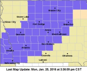
All counties in purple are under a Winter Weather Advisory.
* STORM TOTAL SNOW/ICE ACCUMULATIONS…ANY ICE AMOUNTS SHOULD ONLY BE A FEW HUNDREDTHS OF AN INCH. SNOW AMOUNTS OF UP TO ONE INCH.
* WINDS/VISIBILITY…WINDS WILL INCREASE FROM THE NORTHWEST AT 15 TO 25 MPH WHICH MAY LOWER VISIBILITIES IN RURAL AREAS THIS EVENING FROM BLOWING SNOW.
* IMPACTS…ROADWAYS AND WALKWAYS WILL BECOME SLICK…ESPECIALLY ON UNTREATED AND ELEVATED SURFACES… CAUSING HAZARDOUS DRIVING CONDITIONS. ROAD CONDITIONS WILL CONTINUE TO DETERIORATE AS SNOW AND BLOWING SNOW PERSIST INTO THE EVENING.
MONONA-HARRISON-SHELBY-POTTAWATTAMIE-MILLS-MONTGOMERY-FREMONT-PAGE COUNTIES…THE WINTER WEATHER ADVISORY THAT WAS SET TO EXPIRE AT 3-P.M. IS NOW IN EFFECT UNTIL 6 PM…
* SNOW WILL CONTINUE THROUGH THE REST OF THE AFTERNOON…ENDING BY EARLY THIS EVENING.
* SNOWFALL OF UP TO 2 INCHES ARE EXPECTED…WITH SOME LOCALLY HIGHER AMOUNTS NEAR THE INTERSTATE 80 CORRIDOR IN SOUTHEAST NEBRASKA.
A WINTER WEATHER ADVISORY REMAINS IN EFFECT UNTIL MIDNIGHT FOR:SAC-CRAWFORD-CARROLL-AUDUBON-GUTHRIE-DALLAS AND CASS COUNTIES.
PRECAUTIONARY/PREPAREDNESS ACTIONS…
A WINTER WEATHER ADVISORY MEANS THAT PERIODS OF FREEZING RAIN WILL CAUSE TRAVEL DIFFICULTIES. BE PREPARED FOR SLIPPERY ROADS AND LIMITED VISIBILITIES…AND USE CAUTION WHILE DRIVING. THE LATEST ROAD CONDITIONS FOR THE STATE YOU ARE CALLING FROM CAN BE OBTAINED BY CALLING 5 1 1.
Area police departments are reporting roads have become slippery this afternoon due to freezing drizzle or rain. Authorities in Guthrie and Montgomery County were reporting slick conditions as of 3-p.m. Although the Iowa DOT’s website 511ia.org shows most roads are in “Normal” winter driving condition, Highway 34 west of Highway 59, Interstate 29 from Council Bluffs. Highway 275 and Highway 2, west of Highway 59, were reported to be partially covered with snow.
Beware of black ice on the roads and sidewalks. Conditions are expected to deteriorate as the evening wears on.


