
MONONA-HARRISON-SHELBY-POTTAWATTAMIE-MILLS-MONTGOMERY-FREMONT and PAGE COUNTIES: A WIND ADVISORY IS IN EFFECT UNTIL NOON TODAY. WEST WINDS OF 25 TO 35 MPH WITH GUSTS 40 TO 50 MPH WILL CONTINUE MUCH OF THE MORNING.
SAC-CRAWFORD-CARROLL-AUDUBON-GUTHRIE-DALLAS-CASS-ADAIR-MADISON-ADAMS-UNION-TAYLOR COUNTIES: A WIND ADVISORY WILL BE IN EFFECT FROM 6-A.M. TODAY UNTIL 6-P.M. SUSTAINED WINDS OF 30 MPH OR HIGHER ALONG WITH WIND GUSTS APPROACHING 45 MPH AT TIMES WILL BE COMMON.
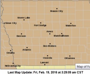
Wind Advisory in effect or slated to go into effect, for all counties shaded in brown.
THE STRONG WINDS WILL CREATE POTENTIALLY HAZARDOUS DRIVING CONDITIONS…ESPECIALLY HIGH PROFILE VEHICLES TRAVELING ALONG NORTH TO SOUTH ROADS.
PRECAUTIONARY/PREPAREDNESS ACTIONS…
A WIND ADVISORY MEANS THAT SUSTAINED WIND SPEEDS BETWEEN 30 TO 39 MPH OR GUSTS BETWEEN 45 TO 57 MPH ARE EXPECTED. WINDS THIS STRONG CAN MAKE DRIVING DIFFICULT…ESPECIALLY FOR HIGH PROFILE VEHICLES. USE EXTRA CAUTION.
EARLY THIS MORNING…MOSTLY CLOUDY. SOUTHEAST WIND 5 TO 15 MPH.
TODAY…PARTLY SUNNY. BREEZY…WARMER. HIGH IN THE LOWER 60S. SOUTH WIND 10 TO 20 MPH WITH GUSTS TO AROUND 30 MPH.
TONIGHT…PARTLY CLOUDY. BREEZY. NOT AS COOL. LOW IN THE MID 40S. SOUTH WIND 10 TO 15 MPH SHIFTING TO THE SOUTHWEST 15 TO 25 MPH AFTER MIDNIGHT.
FRIDAY…SUNNY…BREEZY. HIGH IN THE MID 60S. WEST WIND 15 TO 25 MPH WITH GUSTS TO AROUND 35 MPH.
SATURDAY…SUNNY. HIGH IN THE LOWER 60S. WEST WIND 5 TO 10 MPH.
SUNDAY…PARTLY SUNNY. COOLER. HIGH AROUND 50.
Today: P/Cldy to Cldy w/flurries & fog possible this morning. High 39. E/SE @ 5-10.
Tonight: Mostly cloudy. Areas of fog developing. Low around 35. SE @ 10-15.
Tomorrow: P/Cldy to Cldy. High near 59. S @ 15-25
Friday: P/Cldy & mild. High around 59.
Saturday: P/Cldy. High 54.
Tuesday’s High in Atlantic was 34. The 24-hour Low ending at 7-a.m. today was 29. We received a Trace of snow in the form of snow pellets overnight into early this morning. Last year on this date we reached 25 for a High and -1 was the low. The All-time Record High in Atlantic on this date was 67 in 1981. The Record Low was -34 in 1958.
EARLY THIS MORNING…CLOUDY WITH A 20 PERCENT CHANCE OF LIGHT FREEZING RAIN AND LIGHT SNOW. PATCHY FOG. EAST WIND AROUND 5 MPH.
TODAY…MOSTLY CLOUDY. PATCHY FOG IN THE MORNING. HIGH IN THE LOWER 40S. SOUTHEAST WIND 5 TO 15 MPH.
TONIGHT…MOSTLY CLOUDY. LOW IN THE LOWER 30S. SOUTHEAST WIND 5 TO 15 MPH.
THURSDAY…MOSTLY SUNNY. BREEZY…WARMER. HIGH IN THE LOWER 60S. SOUTH WIND 15 TO 25 MPH.
FRIDAY…SUNNY…BREEZY. HIGH IN THE MID 60S. WEST WIND 15 TO 20 MPH WITH GUSTS TO AROUND 35 MPH.
SATURDAY…MOSTLY SUNNY. HIGH IN THE UPPER 50S.
Today: Rain and snow likely before 11am, then a slight chance of rain between 11am and noon. Cloudy & breezy. High near 36. N @ 10-20.New snow accumulation of less than a half inch possible.
Tonight: Mostly cloudy, with a low around 22. N @ 5-10.
Wednesday: P/Cldy to Cldy. High near 35. E/SE 5 to 10 mph.
Wednesday Night: Partly cloudy, with a low around 30.
Thursday: P/Cldy & mild. High 52.
Friday: P/Cldy & mild. High around 58.
Monday’s High in Atlantic was 45. The 24-hour Low ending at 7-a.m. today was 28. We received .35” of rain overnight into early this morning. Last year on this date we reached 30 for a High and 10 was the low. The All-time Record High in Atlantic on this date was 62 in 1921 & 1961. The Record Low was -33 in 1958.
350 AM CST TUE FEB 16 2016
EARLY THIS MORNING…LIGHT RAIN WITH LIGHT SNOW LIKELY. NOT AS COLD. LITTLE OR NO NEW SNOW ACCUMULATION. NORTHEAST WIND NEAR 10 MPH. CHANCE OF PRECIPITATION NEAR 100 PERCENT.
TODAY…CLOUDY. A CHANCE OF LIGHT SNOW AND A SLIGHT CHANCE OF LIGHT RAIN THROUGH MID MORNING…THEN A SLIGHT CHANCE OF LIGHT RAIN AND LIGHT SNOW BEFORE NOON. BREEZY…COLDER. HIGH IN THE UPPER 30S. NORTHWEST WIND 10 TO 20 MPH. CHANCE OF PRECIPITATION 50 PERCENT.
TONIGHT…MOSTLY CLOUDY. COLDER. LOW IN THE LOWER 20S. NORTHWEST WIND NEAR 10 MPH SHIFTING TO THE EAST AFTER MIDNIGHT.
WEDNESDAY…MOSTLY CLOUDY IN THE MORNING THEN BECOMING MOSTLY SUNNY. HIGH IN THE LOWER 40S. SOUTHEAST WIND 5 TO 10 MPH.
THURSDAY…MOSTLY SUNNY. BREEZY…WARMER. HIGH IN THE UPPER 50S. SOUTH WIND 10 TO 20 MPH WITH GUSTS TO AROUND 30 MPH.
FRIDAY…MOSTLY SUNNY. BREEZY. HIGH IN THE LOWER 60S.
Today: Cldy to P/Cldy w/any flurries ending this morning. High 38. SW @ 10.
Tonight: Cldy w/light snow, possibly mixed w/rain or freezing rain. Low 32. S winds becoming NW @ 10-15.
Tomorrow: Mo. Cldy w/light snow ending. (1”total). High 35. NW @ 10-20.
Tom. Night: Mo. Cldy. Low 24.
Wednesday: Mo. Cldy. High 33.
Thursday: P/Cldy, windy & mild. High around 50.
Sunday’s High in Atlantic was 31. The 24-hour Low ending at 7-a.m. today was 17. We received 1.4” of snow Sunday night into early this morning, which melted into .07” of liquid precipitation. Last year on this date we reached 15 for a High and 5 was the low. The All-time Record High in Atlantic on this date was 72 in 1921. The Record Low was -31 in 1905.
Early This Morning: Cloudy with a 50 percent chance of light snow. Southwest wind near 5 mph.
Today: Cloudy in the morning then becoming partly sunny. High around 40. Southwest wind near 10 mph.
Tonight: Mostly cloudy. A chance of rain and a slight chance of light freezing rain through midnight…then rain and snow likely after midnight. Snow accumulation up to 1 inch. No ice accumulation. Low in the lower 30s. Southwest wind 5 to 15 mph. Gusts up to 30 mph after midnight. Chance of precipitation 70 percent.
Tuesday: Mostly cloudy. Breezy. High in the upper 30s. Northwest wind 20 to 25 mph decreasing to 10 to 20 mph in the afternoon.
Wednesday: Partly sunny. High in the upper 30s. East wind 5 to 10 mph.
Thursday: Partly sunny. Breezy…warmer. High in the lower 50s.
Today: Cloudy with a 50% chance of snow, mainly before 9am. High near 35. South winds @ 10-15 this morning becoming westerly this afternoon. Wind chill values as low as 5New snow accumulation of less than a half inch possible.
Tonight: A slight chance of snow, otherwise mostly cloudy. Low around 23. Winds becoming light and variable overnight. Chance of precipitation is 20%.
Monday (Washington’s Birthday): Partly sunny. High near 38. W/SW winds 5-10
Monday Night: A 50% chance of snow. Low around 30. S/SW @ 5-15mph, with gusts as high as 20. New snow accumulation of less than one inch possible.
Tuesday: Mostly Cloudy & breezy, w/a 20% chance of snow before noon. High near 37.
Wednesday: Partly sunny, with a high near 38.
Skyscan Forecast Saturday, February 13, 2016 Chris Parks

Podcast: Play in new window | Download (804.3KB)
Subscribe: RSS


