
EARLY THIS MORNING…CLOUDY. NOT AS COLD. NORTHEAST WIND 5 TO 10 MPH.
TODAY…CLOUDY THROUGH MID MORNING THEN BECOMING PARTLY SUNNY. HIGH IN THE LOWER 40S. NORTH WIND 10 TO 15 MPH.
TONIGHT…MOSTLY CLOUDY. LOW IN THE UPPER 20S. NORTHEAST WIND NEAR 5 MPH SHIFTING TO THE SOUTHEAST AFTER MIDNIGHT.
FRIDAY…MOSTLY CLOUDY. BREEZY…WARMER. HIGH IN THE LOWER 50S. SOUTH WIND 5 TO 20 MPH.
SATURDAY…SUNNY. HIGH IN THE LOWER 50S. NORTH WIND 5 TO 10 MPH.
SUNDAY…MOSTLY CLOUDY WITH A 20 PERCENT CHANCE OF RAIN SHOWERS. HIGH IN THE UPPER 50S.
The month of February was warmer and wetter than average, here in Atlantic. Weather stats compiled here at KJAN (the official National Weather Service reporting/record keeping site for Atlantic), show the Average High for the month was 39.2 degrees (3.8 degrees warmer than the normal average of 35.4), while the Average Low was 20.2 (5 degrees warmer than normal). Precipitation for the month (including rain/mixed precip. and/snow) amounted to 1.65 inches, which was nearly 7 tenths of an inch above average for the month (normal is .96″).
Snowfall in Atlantic amounted to 9.7 inches last month. The warmest day, which was also a record setter, was 71 set Feb. 27th. That beat the old record of 68 set in 1976). The coldest day was 3 degrees on Feb. 12th.
Today: Cloudy w/flurries possible this morning; P/Cldy this afternoon. High near 30. N/NW @ 15-20. Wind chill values as low as 5.
Tonight: Partly cloudy. Low around 15. Light and variable winds.
Wednesday: Cloudy. High near 43. S/SE @ 15-25.
Wed. Night: Cldy w/a 50% chance of rain before midnight, then a chance of rain and snow. Low around 30. E/SE winds @ 10 becoming N after midnight. Little or no snow accumulation expected.
Thursday: Mostly cloudy, with chance of morning flurries. High near 40.
Friday: P/Cldy to Cldy & breezy. High 48.
Monday’s High in Atlantic was 59. The 24-hour Low ending at 7-a.m. today was 19. We received a Trace of snow overnight here at the KJAN studios. Last year on this date, our High in Atlantic was 38, and the low was 12. The All-time Record High in Atlantic on this date was 77 in 1992. The Record Low was -32 in 1962.
Early This Morning: Cloudy with a 50 percent chance of light snow. Breezy. North wind 15 to 20 mph with gusts to around 30 mph.
Today: Cloudy. Much colder. High in the upper 20s. North wind 10 to 15 mph with gusts to around 30 mph.
Tonight: Partly cloudy. Low in the lower 20s. North wind near 10 mph shifting to the southeast after midnight.
Wednesday: Mostly cloudy. Breezy…warmer. High in the upper 40s. South wind 5 to 15 mph shifting to the southeast 15 to 20 mph in the afternoon.
Wednesday Night: Cloudy. A chance of light rain through midnight… Then a chance of light rain…light freezing rain and a slight chance of light snow after midnight. Low around 30. East wind 5 to 15 mph shifting to the north 5 to 10 mph after midnight. Chance of precipitation 50 percent.
Thursday: Partly sunny. High in the lower 40s. North wind 10 to 15 mph.
Friday: Partly sunny. High around 50.
The Montgomery County Emergency Management Agency reports the Montgomery County Annual Storm Spotter Class will be held 7-p.m. March 16th, at the Viking Center in Stanton ( located at 501 Elliott St). The class is hosted by Montgomery County Emergency Management in conjunction with the National Weather Service in Valley, NE. It is open to the public and free of charge.
Today: P/Cldy to Cldy & breezy. High near 59. S/SW winds becoming N/NE @ 10-25. Tonight: Cloudy w/a 40% chance rain and then snow. Low 25. N @ 15-25. Less than 1” snow expected overnight.
Tuesday: Cloudy & breezy w/a chance of snow thru 9am. High near 31. N @ 10-25.
Tuesday Night: Partly cloudy, with a low around 21.
Wednesday: Partly sunny & breezy. High near 43. S @ 5-15 w/gusts to 25.
Wed. night: Mo. Cldy w/a slight chance of rain before midnight, then a chance of freezing rain. Low around 29.
Thursday: Mo. Cldy w/a slight chance of snow before noon, then a chance of rain. High near 40.
Sunday’s High in Atlantic was 54. The 24-hour Low ending at 7-a.m. today was 24. On the last LEAP Year on this date (2012) we reached 62 for a High and -9 was the low. The All-time Record High in Atlantic on this date was 62 in 1992. The Record Low was -9 in 1960.
EARLY THIS MORNING…MOSTLY CLEAR. COLDER. SOUTHWEST WIND 5 TO 10 MPH.
TODAY…MOSTLY SUNNY UNTIL LATE AFTERNOON THEN BECOMING MOSTLY CLOUDY. HIGH IN THE MID 50S. SOUTHWEST WIND 10 TO 15 MPH SHIFTING TO THE NORTHWEST IN THE AFTERNOON. GUSTS UP TO 25 MPH.
TONIGHT…CLOUDY. A CHANCE OF RAIN THROUGH MIDNIGHT…THEN A CHANCE OF RAIN AND SNOW AFTER MIDNIGHT. LOW IN THE MID 20S. NORTHEAST WIND 10 TO 15 MPH WITH GUSTS TO AROUND 25 MPH. CHANCE OF PRECIPITATION 40 PERCENT.
TUESDAY…MOSTLY CLOUDY. MUCH COLDER. HIGH IN THE LOWER 30S. NORTH WIND AROUND 15 MPH WITH GUSTS TO AROUND 25 MPH.
WEDNESDAY…PARTLY SUNNY. WARMER. HIGH IN THE MID 40S. SOUTH WIND 5 TO 15 MPH.
THURSDAY…MOSTLY CLOUDY WITH A 20 PERCENT CHANCE OF RAIN AND SNOW. HIGH IN THE UPPER 30S.
SPECIAL WEATHER STATEMENT NATIONAL WEATHER SERVICE DES MOINES IA 1248 PM CST SUN FEB 28 2016
EMMET-KOSSUTH-WINNEBAGO-WORTH-PALO ALTO-HANCOCK-CERRO GORDO- POCAHONTAS-HUMBOLDT-WRIGHT-FRANKLIN-BUTLER-BREMER-SAC-CALHOUN- WEBSTER-HAMILTON-HARDIN-GRUNDY-BLACK HAWK-CRAWFORD-CARROLL-GREENE- BOONE-STORY-MARSHALL-TAMA-AUDUBON-GUTHRIE-DALLAS-POLK-JASPER- POWESHIEK-CASS-ADAIR-MADISON-WARREN-MARION-MAHASKA-ADAMS-UNION– CLARKE-LUCAS-MONROE-WAPELLO-TAYLOR-RINGGOLD-DECATUR-WAYNE- APPANOOSE-DAVIS COUNTIES… …GUSTY NORTHWEST WINDS WILL CONTINUE THIS AFTERNOON…
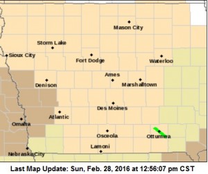
Wind Advisory until 4-p.m. for counties in brown.
NORTHWEST WINDS OF 25 TO 30 MPH WITH GUSTS IN EXCESS OF 40 MPH WILL CONTINUE THIS AFTERNOON AS A COLD FRONT MOVES THROUGH THE STATE. THESE WINDS MAY IMPACT DRIVING CONDITIONS IN RURAL AREAS.
A WIND ADVISORY CONTINUES UNTIL 4-P.M. FOR MONONA-HARRISON-SHELBY-POTTAWATTAMIE-MILLS COUNTIES.
Today: Mostly sunny. Windy…cooler. High in the mid 50s. West wind 10 to 20 mph increasing to northwest 20 to 30 mph in the afternoon. Gusts up to 40 mph.
**Wind Advisory from 8am-4pm for Monona-Harrison-Shelby-Pottawattamie- and Mills Counties**
Tonight: Mostly clear. Colder. Low in the lower 30s. West wind 5 to 10 mph with gusts to around 25 mph shifting to the southwest after midnight.
Monday: Mostly sunny until late afternoon then becoming mostly cloudy. Breezy. High in the upper 50s. Southwest wind 10 to 20 mph shifting to the northwest 10 to 15 mph in the afternoon. Gusts up to 30 mph.
Monday Night: Cloudy. A chance of light rain through midnight… Then a chance of light snow and a slight chance of light rain after midnight. Low in the mid 20s. Northeast wind 10 to 15 mph. Chance of precipitation 40 percent.
Tuesday: Mostly sunny. Much colder. High in the mid 30s. North wind 10 to 15 mph with gusts to around 25 mph.
Wednesday: Partly sunny. Warmer. High in the mid 40s.
MONONA-HARRISON-SHELBY-POTTAWATTAMIE-MILLS COUNTIES: A WIND ADVISORY IS IN EFFECT FROM 8 AM TODAY (SUNDAY) UNTIL 4 PM.
NORTHWEST WINDS WILL BE INCREASING FROM 25 TO 35 MPH, WITH GUSTS UP TO 50 MPH POSSIBLE.
THE STRONG WINDS WILL CREATE POTENTIALLY HAZARDOUS DRIVING CONDITIONS.
PRECAUTIONARY/PREPAREDNESS ACTIONS…
A WIND ADVISORY MEANS THAT SUSTAINED WIND SPEEDS BETWEEN 30 TO
39 MPH OR GUSTS BETWEEN 45 TO 57 MPH ARE EXPECTED. WINDS THIS
STRONG CAN MAKE DRIVING DIFFICULT…ESPECIALLY FOR HIGH PROFILE
VEHICLES. USE EXTRA CAUTION.


