451 AM CDT SUN MAR 13 2016
EARLY THIS MORNING…CLOUDY WITH A 20 PERCENT CHANCE OF LIGHT RAIN AND DRIZZLE. PATCHY FOG. WARMER. SOUTHEAST WIND AROUND 5 MPH.
TODAY…CLOUDY. PATCHY FOG IN THE MORNING. ISOLATED LIGHT SHOWERS AND PATCHY DRIZZLE IN THE MORNING…THEN ISOLATED LIGHT SHOWERS IN THE AFTERNOON. HIGH AROUND 60. SOUTHEAST WIND AROUND 5 MPH. CHANCE OF SHOWERS 20 PERCENT.
TONIGHT…CLOUDY WITH A 20 PERCENT CHANCE OF LIGHT RAIN. LOW IN THE UPPER 40S. SOUTHEAST WIND AROUND 5 MPH.
MONDAY…PARTLY SUNNY. WARMER. HIGH IN THE LOWER 70S. SOUTHWEST WIND 5 TO 10 MPH.
MONDAY NIGHT…MOSTLY CLOUDY. A CHANCE OF LIGHT SHOWERS AND ISOLATED THUNDERSTORMS THROUGH MIDNIGHT…THEN LIGHT SHOWERS LIKELY AND ISOLATED THUNDERSTORMS AFTER MIDNIGHT. LOW IN THE UPPER 40S. SOUTH WIND 5 TO 10 MPH. CHANCE OF PRECIPITATION 60 PERCENT.
TUESDAY…PARTLY SUNNY WITH A 50 PERCENT CHANCE OF LIGHT SHOWERS. BREEZY. HIGH IN THE LOWER 60S. WEST WIND 10 TO 15 MPH WITH GUSTS TO AROUND 25 MPH INCREASING TO 20 TO 25 MPH WITH GUSTS TO AROUND 35 MPH IN THE AFTERNOON.
WEDNESDAY…MOSTLY SUNNY. BREEZY. HIGH IN THE MID 50S.

Podcast: Play in new window | Download (344.2KB)
Subscribe: RSS
Today: Clear to Partly Cloudy. High near 67. SE @ 5-15 w/gusts to near 20.
Tonight: Increasingly cloudy. Low around 45. SE @ 5-10.
Saturday: Cloudy w/a 60% chance of showers, mainly between 9am and noon. High near 58. SE @ 10-15. New precipitation amounts between a tenth and quarter of an inch possible.
Sat. Night: Cloudy w/a 40% chance of showers. Low around 50.
Sunday: Cloudy w/a 40% chance of showers and thunderstorms. High near 66.
Sunday Night: Mo. Cldy w/a 30% chance of showers and thunderstorms before midnight, then a slight chance of showers. Low around 48.
Monday: P/Cldy. High near 70.
Thursday’s High in Atlantic was 66. The 24-hour Low ending at 7-a.m. today was 28. Last year on this date, our High in Atlantic was 66, and the low was 32. The All-time Record High in Atlantic on this date was 69 in 1900. The Record Low was -22 in 1948.
346 AM CST FRI MAR 11 2016
EARLY THIS MORNING…MOSTLY CLEAR. SOUTHEAST WIND NEAR 5 MPH.
TODAY…SUNNY. HIGH IN THE UPPER 60S. SOUTH WIND 5 TO 15 MPH.
TONIGHT…MOSTLY CLEAR. LOW IN THE LOWER 40S. SOUTHEAST WIND 5 TO 10 MPH.
SATURDAY…MOSTLY CLOUDY. COOLER. A CHANCE OF LIGHT SHOWERS THROUGH MID MORNING…THEN LIGHT SHOWERS LIKELY BEFORE NOON. A CHANCE OF LIGHT SHOWERS IN THE AFTERNOON. HIGH IN THE UPPER 50S. SOUTHEAST WIND 5 TO 10 MPH. CHANCE OF SHOWERS 60 PERCENT.
SATURDAY NIGHT…CLOUDY WITH A CHANCE OF LIGHT SHOWERS AND ISOLATED THUNDERSTORMS. LOW AROUND 50. SOUTHEAST WIND 5 TO 10 MPH. CHANCE OF PRECIPITATION 50 PERCENT.
SUNDAY…CLOUDY WITH A CHANCE OF LIGHT SHOWERS AND ISOLATED THUNDERSTORMS. HIGH IN THE UPPER 60S. SOUTH WIND AROUND 5 MPH. CHANCE OF PRECIPITATION 40 PERCENT.
SUNDAY NIGHT…CLOUDY. A CHANCE OF LIGHT SHOWERS AND ISOLATED THUNDERSTORMS THROUGH MIDNIGHT…THEN A SLIGHT CHANCE OF LIGHT SHOWERS AFTER MIDNIGHT. LOW IN THE UPPER 40S. CHANCE OF PRECIPITATION 30 PERCENT.
MONDAY…MOSTLY SUNNY. HIGH AROUND 70.
Today: Areas of fog this morning; Partly Cloudy. High 60. NE @ 5-10mph
Tonight: P/Cldy. Low 32. Light & variable winds.
Tomorrow: P/Cldy. High around 63. SE @ 10-15.
Saturday: Cldy w/rain. High near 58.
Sunday: Cldy w/rain. High 62.
Wednesday’s High in Atlantic was 59. The 24-hour Low ending at 7-a.m. today was 27. Last year on this date, our High in Atlantic was 75, and the low was 25. The All-time Record High in Atlantic on this date was 75 in 2015. The Record Low was -8 in 1948.
346 AM CST THU MAR 10 2016
EARLY THIS MORNING…PARTLY CLOUDY. NORTHEAST WIND NEAR 5 MPH.
TODAY…MOSTLY SUNNY. HIGH IN THE MID 60S. NORTH WIND NEAR 5 MPH.
TONIGHT…MOSTLY CLEAR. LOW IN THE UPPER 30S. SOUTHEAST WIND AROUND 5 MPH.
FRIDAY…SUNNY. HIGH IN THE MID 60S. SOUTH WIND 5 TO 15 MPH.
FRIDAY NIGHT…PARTLY CLOUDY. A 20 PERCENT CHANCE OF LIGHT SHOWERS AFTER MIDNIGHT. LOW IN THE MID 40S. SOUTHEAST WIND 5 TO 10 MPH.
SATURDAY…MOSTLY CLOUDY WITH A 40 PERCENT CHANCE OF LIGHT SHOWERS. HIGH IN THE LOWER 60S. SOUTHEAST WIND 5 TO 10 MPH.
SATURDAY NIGHT…CLOUDY WITH A 40 PERCENT CHANCE OF LIGHT SHOWERS. LOW IN THE LOWER 50S.
SUNDAY…CLOUDY WITH A 40 PERCENT CHANCE OF SHOWERS. HIGH IN THE UPPER 60S.
Today: Partly Cloudy. High 57. NW @ 10-15mph
Tonight: Fair to P/Cldy. Low 30. Light & variable winds.
Tomorrow: P/Cldy. High around 59. SE @ 5-10. Friday: P/Cldy. High near 62.
Saturday: Cldy w/rain. High 58.
Tuesday’s High in Atlantic was 68. The 24-hour Low ending at 7-a.m. today was 30. Last year on this date, our High in Atlantic was 62, and the low was 21. The All-time Record High in Atlantic on this date was 76 in 1986. The Record Low was -10 in 1912.
Early This Morning: Partly cloudy. Colder. Northwest wind 5 to 10 mph.
Today: Mostly sunny. Cooler. High in the upper 50s. Northwest wind 5 to 10 mph.
Tonight: Partly cloudy. Low around 40. Northeast wind 5 to 10 mph.
Thursday: Sunny. High in the lower 60s. Northeast wind 5 to 10 mph.
Thursday Night: Mostly clear. Low in the upper 30s. East wind 5 to 10 mph.
Friday: Sunny. High in the mid 60s. Southeast wind 5 to 15 mph.
Friday Night: Mostly cloudy. A 20 percent chance of showers after midnight. Low in the lower 40s.
Saturday: Showers likely. High in the lower 60s. Chance of showers 60 percent.
331 AM CST TUE MAR 8 2016
EARLY THIS MORNING…CLOUDY WITH A SLIGHT CHANCE OF LIGHT SHOWERS AND ISOLATED THUNDERSTORMS. SOUTH WIND AROUND 15 MPH WITH GUSTS TO AROUND 25 MPH. CHANCE OF PRECIPITATION 20 PERCENT.
TODAY…PARTLY SUNNY. A 20 PERCENT CHANCE OF LIGHT SHOWERS LATE IN THE AFTERNOON. BREEZY. HIGH IN THE UPPER 60S. SOUTHWEST WIND 10 TO 20 MPH WITH GUSTS TO AROUND 30 MPH.
TONIGHT…MOSTLY CLOUDY. A 20 PERCENT CHANCE OF LIGHT SHOWERS UNTIL EARLY MORNING. COLDER. LOW IN THE LOWER 40S. NORTH WIND 5 TO 10 MPH.
WEDNESDAY…PARTLY SUNNY. COOLER. HIGH IN THE MID 50S. NORTH WIND 5 TO 10 MPH.
WEDNESDAY NIGHT…MOSTLY CLOUDY. A CHANCE OF LIGHT SHOWERS THROUGH MIDNIGHT…THEN A SLIGHT CHANCE OF LIGHT SHOWERS AFTER MIDNIGHT. LOW AROUND 40. NORTH WIND AROUND 10 MPH. CHANCE OF SHOWERS 40 PERCENT.
THURSDAY…PARTLY SUNNY. HIGH IN THE UPPER 50S. NORTH WIND AROUND 10 MPH.
FRIDAY…PARTLY SUNNY. HIGH IN THE UPPER 50S.
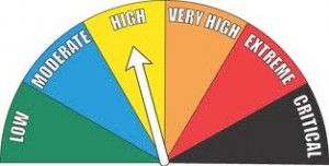
The Shelby County Emergency Management Agency says participating businesses, and fire station in the County, should keep their “FIRE DANGER” signs in the HIGH category for the next few days, as record temperatures and breezy conditions will create near RED FLAG (extreme fire danger) conditions, especially between 11-a.m. and 6-p.m. each day.
Any open burning that can be moved to the early morning or late evening hours, will reduce the potential for fires to rapidly spread. The next update will be Thursday morning.