
EARLY THIS MORNING…CLOUDY. AREAS OF FOG. A CHANCE OF DRIZZLE. SOUTHEAST WIND AROUND 5 MPH.
TODAY…AREAS OF FOG THROUGH MID MORNING. PATCHY FOG IN THE LATE MORNING AND AFTERNOON. DRIZZLE…LIGHT RAIN LIKELY AND A CHANCE OF LIGHT SNOW IN THE MORNING…THEN LIGHT RAIN AND DRIZZLE IN THE AFTERNOON. NO SNOW ACCUMULATION. HIGH IN THE UPPER 30S. EAST WIND 5 TO 10 MPH. CHANCE OF PRECIPITATION 90 PERCENT.
TONIGHT…PATCHY FOG IN THE EVENING. LIGHT RAIN. LOW IN THE LOWER 30S. EAST WIND 5 TO 10 MPH. CHANCE OF RAIN 90 PERCENT.
FRIDAY…CLOUDY. LIGHT RAIN LIKELY IN THE MORNING…THEN A CHANCE OF DRIZZLE AND LIGHT SNOW IN THE AFTERNOON. LITTLE OR NO SNOW ACCUMULATION. HIGH IN THE MID 30S. NORTH WIND 5 TO 10 MPH. CHANCE OF PRECIPITATION 70 PERCENT.
FRIDAY NIGHT…CLOUDY. LIGHT SNOW LIKELY THROUGH MIDNIGHT…THEN A CHANCE OF LIGHT SNOW AFTER MIDNIGHT. COLDER. LOW AROUND 20. NORTH WIND 10 TO 15 MPH WITH GUSTS TO AROUND 25 MPH. CHANCE OF SNOW 70 PERCENT.
SATURDAY…CLOUDY. A CHANCE OF LIGHT SNOW IN THE MORNING…THEN ISOLATED FLURRIES IN THE AFTERNOON. PATCHY BLOWING SNOW THROUGH THE DAY. BREEZY…COLDER. HIGH AROUND 20. NORTH WIND 15 TO 20 MPH WITH GUSTS TO AROUND 30 MPH. CHANCE OF SNOW 30 PERCENT.
SATURDAY NIGHT…MOSTLY CLOUDY. BREEZY…COLDER. PATCHY BLOWING SNOW THROUGH MIDNIGHT. LOW ZERO TO 5 ABOVE.
SUNDAY…MOSTLY SUNNY. COLDER. HIGH 5 TO 10 ABOVE.
Today: Cloudy w/a 50% chance of snow before 5pm, then a chance of snow and freezing rain. High near 34. S @ 10-20. New snow accumulation of less than a half inch possible.
Tonight: A 40% chance of drizzle, snow, and freezing rain before 9pm, then a chance of drizzle. Low around 32. S @ 5-10. outh wind 6 to 11 mph. Little or no snow accumulation expected.
Thursday: A 70% chance of drizzle before noon, then rain likely after noon. High near 36. E @ 5-10. New precipitation amounts between a tenth and quarter of an inch possible.
Thu. Night: Rain before midnight, then snow and freezing rain mixed. Low around 31. New ice accumulation of less than a 0.1 of an inch possible. New snow accumulation of less than a half inch possible. Chance of precipitation is 80%.
Friday: Drizzle likely before 9am, then rain likely between 9am and 3pm, then rain and snow mixed likely after 3pm. High near 34. N @ 10.Chance of precipitation is 70%. New precipitation amounts of less than a tenth of an inch possible.
Friday Night: A 40% chance of snow. Low around 20.
Saturday: Cloudy & blustery w/a slight chance of snow & patchy blowing snow. High near 21.
Tuesday’s High in Atlantic was 32. Our 24-hour ending at 7-a.m. today, was 19. Last year on this date we reached 13 for a High and -4 was the low. The All-time Record High in Atlantic on this date was 56 in 1933, while the Record Low was -24 in 1910.
POTTAWATTAMIE-MILLS-MONTGOMERY-FREMONT-PAGE COUNTIES:
A WINTRY MIXTURE OF RAIN…SLEET AND SNOW WILL MOVE THROUGH THE AREA EARLY THIS MORNING. WHILE THE PRECIPITATION WILL BE VERY LIGHT…SURFACE TEMPERATURES ARE HOVERING RIGHT AROUND FREEZING. THUS BE PREPARED FOR SOME SLICK SPOTS ON ROADS THIS MORNING… ESPECIALLY ON UNTREATED OR ELEVATED SURFACES.
350 AM CST WED JAN 6 2016
EARLY THIS MORNING…CLOUDY WITH A 20 PERCENT CHANCE OF LIGHT FREEZING RAIN AND LIGHT SNOW. NOT AS COLD. SOUTH WIND 10 TO 15 MPH.
TODAY…CLOUDY. A CHANCE OF LIGHT SNOW UNTIL LATE AFTERNOON…THEN A CHANCE OF LIGHT SNOW AND A SLIGHT CHANCE OF LIGHT FREEZING RAIN LATE IN THE AFTERNOON. HIGH IN THE MID 30S. SOUTH WIND 10 TO 15 MPH. CHANCE OF PRECIPITATION 50 PERCENT.
TONIGHT…CLOUDY. A CHANCE OF DRIZZLE…FREEZING DRIZZLE…A SLIGHT CHANCE OF LIGHT FREEZING RAIN AND LIGHT SNOW IN THE EVENING…THEN A CHANCE OF DRIZZLE OVERNIGHT. LOW IN THE LOWER 30S. SOUTH WIND 5 TO 10 MPH. CHANCE OF PRECIPITATION 20 PERCENT.
THURSDAY…CLOUDY. A CHANCE OF DRIZZLE IN THE MORNING…THEN LIGHT RAIN LIKELY IN THE AFTERNOON. HIGH IN THE UPPER 30S. SOUTHEAST WIND 5 TO 10 MPH. CHANCE OF RAIN 70 PERCENT.
THURSDAY NIGHT…LIGHT RAIN THROUGH MIDNIGHT…THEN LIGHT FREEZING RAIN AND LIGHT SNOW AFTER MIDNIGHT. LOW IN THE LOWER 30S. NORTHEAST WIND AROUND 5 MPH. CHANCE OF PRECIPITATION 90 PERCENT.
FRIDAY…DRIZZLE AND LIGHT RAIN LIKELY IN THE MORNING…THEN LIGHT RAIN AND LIGHT SNOW LIKELY IN THE AFTERNOON. HIGH IN THE MID 30S. NORTH WIND 5 TO 10 MPH. CHANCE OF PRECIPITATION 70 PERCENT.
FRIDAY NIGHT…CLOUDY WITH A 40 PERCENT CHANCE OF LIGHT SNOW. COLDER. LOW AROUND 20.
SATURDAY…CLOUDY WITH A 20 PERCENT CHANCE OF LIGHT SNOW. PATCHY BLOWING SNOW. BREEZY…COLDER. HIGH IN THE LOWER 20S.
Today: Partly sunny. High near 35. S @ 10-20 w/gusts to 25.
Tonight: Mostly Cloudy w/a slight chance of freezing drizzle mixing w/snow after midnight. Low around 27. S @ 15-25.
Wednesday: A chance of snow and freezing rain before 9am, then patchy snow and freezing drizzle through Noon. Rain/snow mix possible after Noon. High 34. S @ 10-20. Little or no snow accumulation expected.
Wednesday Night: A chance of rain and snow before midnight, then a chance of freezing drizzle. Low around 32. South wind 5 to 10 mph. Little or no snow accumulation expected.
Thursday: A 40 percent chance of rain. High near 37. S/SE @ 5-10.
Thursday Night: Rain likely before midnight, then rain and snow likely. Low around 33.
Friday: A 50% chance of rain and snow. High near 36.
Monday’s High in Atlantic was 23. Our 24-hour ending at 7-a.m. today, was 7. Last year on this date we reached 18 for a High and -2 was the low. The All-time Record High in Atlantic on this date was 62 in 2012, while the Record Low was -26 in 2010.
Early This Morning: Partly cloudy. Patchy fog. South wind around 10 mph.
Today: Partly sunny. Breezy. Patchy fog through mid morning. High in the mid 30s. South wind 10 to 20 mph.
Tonight: Mostly cloudy. A 20 percent chance of freezing drizzle and light snow early in the morning. Not as cold. Low in the mid 20s. South wind around 15 mph with gusts to around 25 mph.
Wednesday: Cloudy with a 40 percent chance of light snow. High in the mid 30s. South wind 10 to 15 mph.
Wednesday Night: Cloudy. A chance of light rain and light snow through midnight…then a chance of light rain and light freezing rain after midnight. Low in the lower 30s. South wind 5 to 15 mph. Chance of precipitation 40 percent.
Thursday: Cloudy. A chance of light rain and freezing drizzle in the morning…then a chance of light rain in the afternoon. High in the upper 30s. Southeast wind 5 to 10 mph. Chance of precipitation 50 percent.
Thursday Night: Rain likely through midnight…then rain…snow and freezing rain likely after midnight. Low in the lower 30s. Chance of precipitation 70 percent.
Friday: Cloudy with a 50 percent chance of snow and rain. High in the mid 30s.
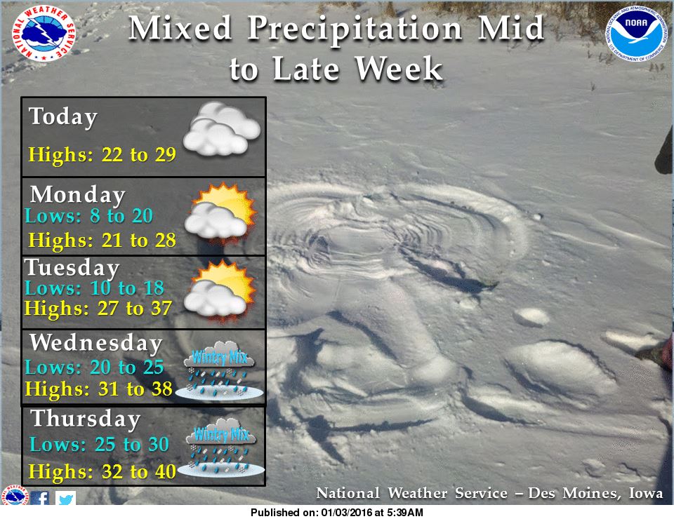
331 AM CST MON JAN 4 2016
EARLY THIS MORNING…CLOUDY. PATCHY FOG. NORTH WIND NEAR 5 MPH.
TODAY…MOSTLY CLOUDY. PATCHY FOG THROUGH MID MORNING. HIGH IN THE MID 20S. NORTHEAST WIND NEAR 5 MPH SHIFTING TO THE SOUTH IN THE AFTERNOON.
TONIGHT…MOSTLY CLOUDY. LOW 15 TO 20. SOUTH WIND 5 TO 15 MPH.
TUESDAY…PARTLY SUNNY. BREEZY. HIGH IN THE LOWER 30S. SOUTH WIND 15 TO 20 MPH.
WEDNESDAY…CLOUDY. A SLIGHT CHANCE OF LIGHT SNOW IN THE MORNING, THEN A CHANCE OF LIGHT RAIN AND LIGHT SNOW IN THE AFTERNOON. HIGH IN THE MID 30S. SOUTH WIND 10 TO 15 MPH. CHANCE OF PRECIPITATION 40 PERCENT.
WEDNESDAY NIGHT…CLOUDY WITH A 40 PERCENT CHANCE OF LIGHT SNOW. LOW IN THE LOWER 30S.
THURSDAY…CLOUDY. A CHANCE OF RAIN IN THE MORNING, THEN A CHANCE OF RAIN AND DRIZZLE IN THE AFTERNOON. HIGH IN THE UPPER 30S. CHANCE OF RAIN 50 PERCENT.
The National Weather Service says it will be cooler today (Sunday) and low clouds will work their way down from Minnesota and Wisconsin making for a cloudy day as well. Highs today and Monday will only be in the 20s. Temperatures will begin to rise some for Tuesday ahead of a weak disturbance. The weak disturbance will come through Wednesday with mainly light snow during the day and some mixed precipitation at night.
 A stronger system comes in for Thursday through Saturday morning bringing more mixed precipitation which will change over to all snow by late Friday. Travel conditions may deteriorate mid to especially late week. Stay tuned for future updates regarding the end of the week.
Today: Sunny, with a high near 34. Wind chill values as low as 5. West wind 5 to 10 mph.
Tonight: Mostly clear, with a low around 14. Wind chill values as low as 5. West wind 5 to 10 mph becoming north after midnight.
Sunday: Sunny, with a high near 25. Wind chill values as low as zero. North wind around 10 mph.
Sunday Night: Partly cloudy, with a low around 11. Wind chill values as low as zero. North northwest wind 5 to 10 mph.
Monday: Mostly sunny, with a high near 23. North wind around 5 mph becoming east southeast in the afternoon.
Tuesday: Partly sunny, with a high near 29. Breezy.

Podcast: Play in new window | Download (572.8KB)
Subscribe: RSS
The month of December was much warmer and wetter than normal. Our average High for the month (at the KJAN studios, the Official National Weather Service reporting site for Atlantic), was 39.1 degrees, or 6.2 degrees warmer than the average. The average Low for Dec. 2015 was 22.3 degrees, which was 7.9 degrees warmer than normal.
Precipitation for the month (both rain and melted snowfall), amounted to 6.08 inches, which was well above the average of 1.11 inches for December. Snowfall for the month was 12.1 inches.
Precipitation for 2015 in Atlantic was 46.94 inches, or 12 inches greater than the normal annual average of 34.94 inches. The average annual high temperature for 2015 in Atlantic was 61.3 degrees, which was 1.3 degrees warmer than normal, while the average low for the 12 month period was 37.8, or 11 degrees cooler than normal.


