
**Winter Storm Warning in effect**
Today: Snow/blowing snow, possibly mixed at times w/freezing rain. High 28. N @ 15-30. (6-10” possible in the Atlantic area).
Tonight: Snow tapering off to flurries by midnight. Low 15. N @ 20-35.
Tomorrow: P/Cldy to Cldy. High around 20. N @ 10-20.
Wednesday: Mo. Cldy w/flurries. High 22.
Thursday: P/Cldy. High 20.
Sunday’s High in Atlantic was 23. Our 24-hour ending at 7-a.m. today, was 11. We received .2” of snow early this morning (as of 7-a.m.). Last year on this date we reached 34 for a High and 15 was the low. The All-time Record High in Atlantic on this date was 65 in 1893 & 1984, while the Record Low was -25 in 1924.
**Winter Storm Warning in effect now until Midnight**
Early This Morning: Cloudy with a 50 percent chance of light snow. Breezy. Northeast wind 15 to 25 mph with gusts to around 35 mph.
Today: Snow. Areas of blowing snow. Windy. Snow may be heavy at times in the morning. Snow accumulation around 7 inches. High in the upper 20s. Northeast wind 20 to 30 mph with gusts to around 45 mph. Chance of snow near 100 percent.
Tonight: Cloudy…breezy. Light snow in the evening…then light snow likely before midnight. A chance of light snow after midnight. Snow accumulation around 1 inch. Low around 20. North wind 15 to 20 mph. Gusts up to 35 mph through midnight. Chance of snow 90 percent.
Tuesday: Mostly cloudy. High in the mid 20s. West wind 5 to 15 mph.
Tuesday Night: Cloudy. A 20 percent chance of light snow after midnight. Low around 15. West wind 5 to 10 mph.
Wednesday: Mostly cloudy. A 20 percent chance of light snow in the morning. High in the lower 20s. West wind 5 to 10 mph.
Wednesday Night: Mostly cloudy. Low 5 to 10 above.
Thursday: Partly sunny. High around 15.
A Snow Emergency will go into effect at midnight tonight (Sunday) for the City of Red Oak. That means:
***No Parking on Emergency Snow Routes at anytime during the snow event.
***No Parking on East – West Streets or Circle Drives on even calender days.
***No Parking on North – South Streets on odd calender days.
***No Parking in alleyways or on city owned property until snow has ceased and been cleared.
231 PM CST SUN DEC 27 2015
A WINTER STORM WARNING REMAINS IN EFFECT FROM 3 AM MONDAY TO MIDNIGHT CST TUESDAY NIGHT.
TONIGHT…MOSTLY CLOUDY. A SLIGHT CHANCE OF LIGHT SNOW AFTER MIDNIGHT. A CHANCE OF LIGHT SNOW EARLY IN THE MORNING. BREEZY. LOW 15 TO 20. NORTHEAST WIND 15 TO 25 MPH. CHANCE OF SNOW 50 PERCENT.
MONDAY…SNOW…WINDY. SNOW MAY BE HEAVY AT TIMES IN THE AFTERNOON. SNOW ACCUMULATION OF 5 TO 6 INCHES. HIGH IN THE UPPER 20S. NORTHEAST WIND 20 TO 30 MPH WITH GUSTS TO AROUND 40 MPH. CHANCE OF SNOW NEAR 100 PERCENT.
MONDAY NIGHT…CLOUDY. LIGHT SNOW THROUGH MIDNIGHT…THEN A CHANCE OF LIGHT SNOW AFTER MIDNIGHT. SNOW ACCUMULATION AROUND 1 INCH. LOW IN THE LOWER 20S. NORTH WIND 10 TO 15 MPH. GUSTS UP TO 30 MPH THROUGH MIDNIGHT. CHANCE OF SNOW 90 PERCENT.
TUESDAY…MOSTLY CLOUDY. HIGH IN THE MID 20S. WEST WIND 5 TO 15 MPH.
TUESDAY NIGHT…CLOUDY WITH A 20 PERCENT CHANCE OF LIGHT SNOW. LOW AROUND 15. WEST WIND AROUND 5 MPH.
WEDNESDAY…CLOUDY WITH A 20 PERCENT CHANCE OF SNOW. HIGH IN THE LOWER 20S.
Today: Cloudy this morning. Gradually becoming mostly sunny. High near 24. N/NE winds 15-30mph. Wind chill values as low as 10.
Tonight: Partly Cloudy to Cloudy w/a 40% chance of snow, mainly after 4am. Low around 18. N/NE winds 15-30mph. Wind chill values as low as 5. New snow accumulation of around an inch possible. **Winter Storm Warning in effect from 3-am Monday until midnight**
Monday: Snow, likely heavy at times. High near 29. NE winds 20-to near 40mph. Wind chill values as low as 5. New snow accumulation of 4 to 8 inches possible.
Monday Night: Snow, mainly before midnight. Low around 22. NW winds 15-30 decreasing to around 10-15mph after midnight. New snow accumulation of less than one inch possible.
Tuesday: Mostly cloudy, with a high near 25. West northwest wind 5 to 15 mph.
Tuesday Night: Cloudy w/a 20% chance of snow. Low around 15.
Wednesday: Mostly Cloudy w/a 20% chance of snow. High near 21.
Saturday’s High in Atlantic was 34. Our 24-hour ending at 7-a.m. today, was 20. We received .01” of drizzle/mist from 7-am yesterday thru 7-am today. Last year on this date we reached 27 for a High and 13 was the low. The All-time Record High in Atlantic on this date was 65 in 1946, while the Record Low was -21 in 1924.
427 AM CST SUN DEC 27 2015
WINTER STORM WARNING IN EFFECT FROM 3 AM MONDAY TO MIDNIGHT MONDAY NIGHT.
EARLY THIS MORNING: CLOUDY AND BREEZY. NORTH WIND 20 TO 25 MPH WITH GUSTS TO AROUND 35 MPH.
TODAY: CLOUDY IN THE MORNING THEN BECOMING PARTLY SUNNY AND BREEZY. COLDER. HIGH IN THE MID 20S. NORTH WIND 15 TO 20 MPH WITH GUSTS TO AROUND 30 MPH.
TONIGHT: MOSTLY CLOUDY. A SLIGHT CHANCE OF LIGHT SNOW AFTER MIDNIGHT. A CHANCE OF LIGHT SNOW EARLY IN THE MORNING. BREEZY. LOW 15 TO 20. NORTHEAST WIND 15 TO 25 MPH. CHANCE OF SNOW 50 PERCENT.
MONDAY: SNOW…WINDY. SNOW MAY BE HEAVY AT TIMES IN THE AFTERNOON. SNOW ACCUMULATION OF 5 TO 6 INCHES. HIGH IN THE UPPER 20S. NORTHEAST WIND 20 TO 30 MPH WITH GUSTS TO AROUND 40 MPH. CHANCE OF SNOW NEAR 100 PERCENT.
MONDAY NIGHT: CLOUDY. LIGHT SNOW THROUGH MIDNIGHT…THEN A CHANCE OF LIGHT SNOW AFTER MIDNIGHT. LOW IN THE LOWER 20S. NORTH WIND 10 TO 15 MPH. GUSTS UP TO 30 MPH THROUGH MIDNIGHT. CHANCE OF SNOW 90 PERCENT.
TUESDAY: MOSTLY CLOUDY. HIGH IN THE MID 20S. WEST WIND 5 TO 15 MPH.
TUESDAY NIGHT: CLOUDY WITH A 20 PERCENT CHANCE OF LIGHT SNOW. LOW AROUND 15.
WEDNESDAY: CLOUDY WITH A 20 PERCENT CHANCE OF SNOW. HIGH IN THE LOWER 20S.
Today: Cloudy with fog early and isolated rain showers. High of 37. Winds E-NNW at 5-15 mph.
Tonight: Mostly cloudy with isolated snow showers ending late, a low of 24. Winds NNW-N at 10-20mph.
Sunday: Mostly cloudy with a high of 28. Winds N 8-17.
Sunday night: Mostly cloudy with snow/sleet and a low of 21. Winds NE at 10-20 mph.
Monday: Mostly cloudy with snow/sleet early and snow late and a high of 30.
Monday night: Mostly cloudy with snow ending and a low of 21.
Tuesday: Mostly cloudy with a high of 25.
Tuesday night : Mostly cloudy with a low of 15.
Friday’s High in Atlantic was 33. Our 24-hour ending at 7-a.m. today, was 22. We received .11” of rain from 7-am yesterday thru 7-am today (the precipitation fell overnight into early this morning. Last year on this date we reached 33 for a High and 24 was the low. The All-time Record High in Atlantic on this date was 59 in 1936, while the Record Low was -18 in 1892.
The National Weather Service in Des Moines says a significant winter storm is expected to impact much of Iowa on Monday into early Tuesday. Officials say a strong low pressure system will bring widespread precipitation in the form of a wintry mix to central and southern Iowa Monday morning before gradually switching to snow during the afternoon hours.
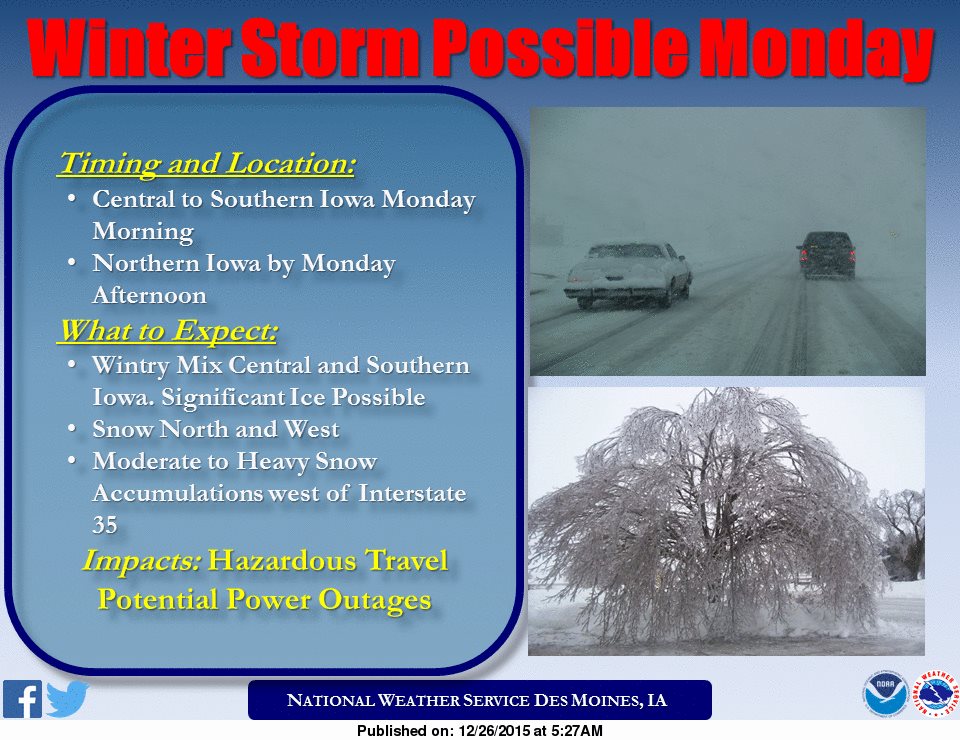 Ice accumulations greater than one quarter inch may occur before the precipitation switches to all snow. Heavy snowfall is possible especially west of Interstate 35 with accumulations greater than 6 inches possible. These conditions in addition to strong and gusty will lead to treacherous travel conditions Monday afternoon and night.
Stay tuned to KJAN for future updates regarding this potentially significant winter storm.
Early this morning: A 50 percent chance of rain. Cloudy, with a steady temperature around 34. East wind around 15 mph, with gusts as high as 21 mph. New precipitation amounts of less than a tenth of an inch possible.
Today: A 50 percent chance of rain, mainly before 5pm. Cloudy, with a high near 38. Breezy, with an east wind 9 to 16 mph becoming north in the afternoon. Winds could gust as high as 21 mph. New precipitation amounts of less than a tenth of an inch possible.
Tonight: A slight chance of rain, mixing with snow after 9pm, then gradually ending. Cloudy, with a low around 23. Windy, with a north wind 17 to 22 mph, with gusts as high as 29 mph. Chance of precipitation is 20%.
Sunday: Partly sunny, with a high near 28. Wind chill values as low as 5. Windy, with a north wind 17 to 21 mph, with gusts as high as 26 mph.
Sunday Night: A 30 percent chance of snow after midnight. Mostly cloudy, with a low around 20. Windy, with a north northeast wind 17 to 21 mph, with gusts as high as 26 mph. New snow accumulation of less than a half inch possible.
Monday: Snow likely. Cloudy, with a high near 29. Windy. Chance of precipitation is 70%.
Monday Night: A 50 percent chance of snow. Cloudy, with a low around 20. Blustery.
Tuesday: A 20 percent chance of snow. Mostly cloudy, with a high near 25.
AREA COUNTIES:SAC-CRAWFORD-CARROLL-AUDUBON-GUTHRIE–
320 AM CST SAT DEC 26 2015
…LIGHT WINTRY MIX RESULTING IN SLICK ROADS...
A LIGHT MIX OF SNOW AND FREEZING RAIN WILL MOVE THROUGH THE AREA DURING THE EARLY MORNING HOURS. ANY ICE AND SNOW AMOUNTS WILL BE VERY LIGHT…BUT WILL RESULT IN SOME SLICK ROADS AND HAZARDOUS DRIVING CONDITIONS AT TIME. PLEASE ALLOW EXTRA TIME FOR TRAVEL. ACCUMULATING PRECIPITATION WILL LARGELY END BY SUNRISE AND TEMPERATURES WILL THEN RISE ABOVE FREEZING AS WELL.


