
The TEST TORNADO WATCH that was issued for all 99 counties in Iowa, will be allowed to expire at 11-a.m. This concludes this portion of Severe Weather Awareness week in Iowa. Thank you for your participation.
NATIONAL WEATHER SERVICE OMAHA/VALLEY NEBRASKA
1009 AM CDT WED MAR 25 2015
…THIS MESSAGE IS FOR TEST PURPOSES ONLY…
THE NATIONAL WEATHER SERVICE HAS ISSUED A TEST TORNADO WARNING FOR ALL COUNTIES IN THE KJAN LISTENING AREA.
* THIS IS A TEST MESSAGE. UNTIL 1030 AM CDT
* THIS IS A TEST MESSAGE. AT 1010 AM CDT…THIS TEST TORNADO WARNING IS BEING ISSUED AS PART OF THE SEVERE WEATHER AWARENESS WEEK ANNUAL DRILL…REPEAT DRILL. THIS ANNUAL DRILL IS THE HIGHLIGHT OF SEVERE WEATHER AWARENESS WEEK. ALL SCHOOLS…HOSPITALS… BUSINESSES…OTHER INSTITUTIONS AND THOSE AT HOME ARE URGED TO TREAT THIS AS IF IT WERE A REAL EMERGENCY. NOW IS AN EXCELLENT TIME TO PRACTICE YOUR SEVERE WEATHER EMERGENCY PLANS.
HAZARD…TEST TORNADO.
SOURCE…THIS IS A TEST.
IMPACT…THIS IS A TEST.
* THIS IS A TEST MESSAGE. THIS IS A TEST TORNADO WARNING.
PRECAUTIONARY/PREPAREDNESS ACTIONS… THIS IS A TEST. TAKE COVER NOW! MOVE TO A BASEMENT OR AN INTERIOR ROOM ON THE LOWEST FLOOR OF A STURDY BUILDING. AVOID WINDOWS. IF YOU ARE OUTDOORS…IN A MOBILE HOME…OR IN A VEHICLE…MOVE TO THE CLOSEST SUBSTANTIAL SHELTER AND PROTECT YOURSELF FROM FLYING DEBRIS. THIS IS A TEST…REPEAT TEST.
The Montgomery County Emergency Management Agency reports a ban on open burning which had been in effect since March 16th, has been lifted. The ban was rescinded due to the current wet conditions.
THE NATIONAL WEATHER SERVICE HAS ISSUED TEST TORNADO WATCH
9999 IN EFFECT UNTIL 11 AM CDT THIS MORNING FOR ALL 99 COUNTIES IN IOWA.
THIS TEST TORNADO WATCH INITIATES THE TEST WATCH PHASE OF THE IOWA SEVERE WEATHER AWARENESS WEEK’S TORNADO DRILL. REPEATING…THIS IS ONLY A TEST WATCH.
THIS IS A TEST MESSAGE. DO NOT TAKE ACTION BASED ON THIS TEST MESSAGE.
The Freese-Notis forecast for the KJAN listening area and weather info. for Atlantic.

Podcast: Play in new window | Download (1.0MB)
Subscribe: RSS
When weather forecasts predict the possibility of a tornado in your area, it is imperative you and your family have a plan to respond to the threat. The National Weather Service, as part of Severe Weather Awareness Week, offers these tips:
Before a Tornado Watch or Warning is issued…
Pick a tornado safe room in your home or place of business. Basements, storms cellars or an interior room with no windows on the lowest floor of a structure offers the best protection.
Make sure all members of your family know where to go.
Store emergency supplies such as a first-aid kit, and flashlights with extra batteries nearby.
Put together a family communications plan. Know where everyone is or will be in the event they are away from home.
During a Tornado Warning…
Immediately go to your Tornado Safe Room. If you are outside, seek shelter inside a sturdy building.
Mobile homes are NEVER safe during a tornado. If you are in a mobile home or a recreational vehicle, head for the nearest storm shelter.
If you cannot quickly walk to a shelter, you should immediately get into a vehicle, buckle your seat belt, and try to drive away from the threat to the nearest sturdy shelter.
After a Tornado…
If you are in an area that was damaged, be careful of debris that may include sharp or dangerous objects, and watch out for downed power lines and broken gas lines.
Use battery powered flashlights when examining buildings. DO NOT USE CANDLES, which can start a fire or cause an explosion.
If you smell gas or hear a blowing or hissing noise, open a window and get everyone out of the building quickly. After everyone is safe, call the gas company or local fire department.
Use your telephone only for emergency calls, so rescue operation lines are not tied-up.
Text your family and friends to let them know you are okay.
If you were outside the area damaged by a tornado, stay off the phone so that emergency calls can get through.
Use text messages and/or social media to let your family and friends know you are okay.
Stay away from areas that are damaged, so you do not hamper rescue operations.
Return to areas that were damaged ONLY when law enforcement gives the all-clear.
Counties: CRAWFORD-CARROLL-AUDUBON-GUTHRIE-CASS-ADAIR-ADAMS-UNION-TAYLOR-RINGGOLD; 518 AM CDT WED MAR 25 2015
…LOCALIZED DENSE FOG THIS MORNING…
AREAS OF FOG CAN BE EXPECTED ACROSS THE AREA THIS MORNING THROUGH 9 AM. THE FOG WILL BE LOCALLY DENSE AT TIMES. A FRONTAL BOUNDARY MOVING SOUTHEAST WILL ARRIVE BY MID MORNING AND BRING IMPROVED CONDITIONS.
A statewide Tornado Drill will take place this morning in Iowa and Nebraska. The drill is part of Severe Weather Awareness Week, and is designed to inform residents on what they should do if a tornado threatens your area. 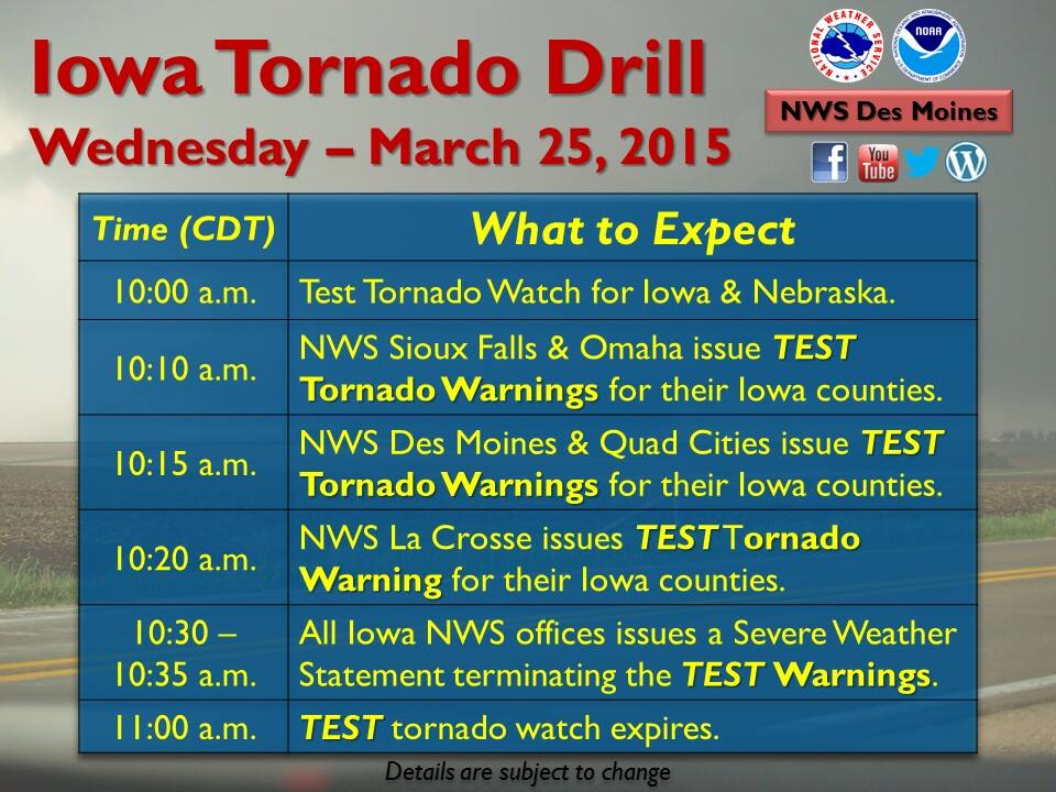
Here is the schedule for today:
9:50 AM – The Storm Prediction Center (SPC) coordinates with Iowa/Nebraska National Weather Service (NWS) offices about a test tornado watch for Iowa and Nebraska.
10:00 AM – SPC issues Test Tornado Watch for Iowa and Nebraska. Each Iowa/Nebraska NWS offices will issue test Watch Coordination Notification messages. Test watch will be toned alerted on NOAA All Hazards Radio.
10:10 AM – NWS Sioux Falls and Omaha issue test tornado warnings for their Iowa counties.
10:15 AM – NWS Des Moines and Quad Cities issue test tornado warnings for their Iowa counties.
10:20 AM – NWS La Crosse issues test tornado warning for their Iowa counties.
10:30-10:35 AM – All Iowa NWS offices issues a Severe Weather Statement to terminate the test warnings.
11:00 AM – Test tornado watch expires.
330 AM CDT WED MAR 25 2015
…DENSE FOG ADVISORY IN EFFECT UNTIL 10 AM CDT THIS MORNING…
THE NATIONAL WEATHER SERVICE IN OMAHA/VALLEY HAS ISSUED A DENSE FOG ADVISORY…WHICH IS IN EFFECT UNTIL 10 AM CDT THIS MORNING.
* VISIBILITY…VISIBILITY WILL BE 1/4 MILE OR LESS IN MOST AREAS.
* IMPACTS…THE DENSE FOG WILL MAKE TRAVEL HAZARDOUS DUE TO LIMITED VISIBILITY THROUGH MID MORNING.
PRECAUTIONARY/PREPAREDNESS ACTIONS…
A DENSE FOG ADVISORY MEANS VISIBILITIES WILL FREQUENTLY BE REDUCED TO LESS THAN ONE QUARTER MILE. IF DRIVING…SLOW DOWN… USE YOUR HEADLIGHTS…AND LEAVE PLENTY OF DISTANCE AHEAD OF YOU.
330 AM CDT WED MAR 25 2015
EARLY THIS MORNING…MOSTLY CLOUDY. AREAS OF FOG. WEST WIND AROUND 5 MPH.
TODAY…MOSTLY CLOUDY. AREAS OF FOG THROUGH MID MORNING. A SLIGHT CHANCE OF LIGHT RAIN THROUGH MID MORNING…THEN A CHANCE OF LIGHT RAIN IN THE LATE MORNING AND EARLY AFTERNOON. A SLIGHT CHANCE OF LIGHT RAIN LATE IN THE AFTERNOON. HIGH IN THE UPPER 40S. NORTHWEST WIND 5 TO 15 MPH WITH GUSTS TO AROUND 25 MPH. CHANCE OF RAIN 30 PERCENT.
TONIGHT…MOSTLY CLOUDY IN THE EVENING THEN CLEARING. LOW IN THE MID 20S. NORTHWEST WIND 10 TO 15 MPH.
THURSDAY…MOSTLY SUNNY. HIGH IN THE MID 40S. NORTHWEST WIND 10 TO 15 MPH.
FRIDAY…MOSTLY SUNNY. HIGH IN THE MID 40S. NORTH WIND 5 TO 10 MPH.
FRIDAY NIGHT…MOSTLY CLOUDY. A CHANCE OF RAIN AND SNOW THROUGH MIDNIGHT…THEN A CHANCE OF SNOW AFTER MIDNIGHT. LOW IN THE UPPER 20S. CHANCE OF PRECIPITATION 30 PERCENT.
SATURDAY…MOSTLY CLOUDY. HIGH IN THE UPPER 40S.


