
AREA COUNTIES: CASS-ADAIR-ADAMS-AUDUBON-CARROLL-CRAWFORD-DALLAS-GREENE-GUTHRIE-MADISON-RINGGOLD-TAYLOR & UNION...
THE NATIONAL WEATHER SERVICE IN DES MOINES HAS ISSUED A RED FLAG
WARNING FOR EXTREME FIRE CONDITIONS…WHICH IS IN EFFECT TODAY FROM 1 PM TO 7 PM.
* TIMING…THE WIND WILL STEADILY INCREASE THROUGH THE MORNING BECOMING STRONG AND GUSTY THIS AFTERNOON. THE MOST DANGEROUS
CONDITIONS WILL EXIST BETWEEN 2 PM AND 5 PM.
* WIND…SOUTH INCREASING TO 25 TO 35 MPH WITH GUSTS AROUND 40 MPH AT TIMES.
* RELATIVE HUMIDITY…WILL DROP TO BETWEEN 30 AND 35 PERCENT AND
COULD POTENTIALLY DROP LOWER.
* FUEL…GRASSES REMAIN NEARLY 100 PERCENT CURED AND SURFACE FUELS ARE HIGHLY COMBUSTIBLE.
* IMPACTS…ANY FIRES WILL SPREAD VERY RAPIDLY AND BE VERY DIFFICULT TO CONTROL IN THESE DANGEROUS CONDITIONS. OUTDOOR BURNING IS HIGHLY DISCOURAGED AND SHOULD BE AVOIDED.
PRECAUTIONARY/PREPAREDNESS ACTIONS…
A RED FLAG WARNING MEANS THAT CRITICAL FIRE WEATHER CONDITIONS
ARE EITHER OCCURRING NOW…OR WILL SHORTLY. A COMBINATION OF
STRONG WINDS…LOW RELATIVE HUMIDITY…AND WARM TEMPERATURES WILL
CREATE EXPLOSIVE FIRE GROWTH POTENTIAL.
330 AM CDT WED APR 1 2015
RED FLAG WARNING IN EFFECT FROM 1-PM TO 7-PM for Cass & area Counties; WIND ADVISORY IN EFFECT FROM 1 PM to 6 PM FOR CASS & AREA COUNTIES;
EARLY THIS MORNING…MOSTLY CLEAR. SOUTH WIND 5 TO 10 MPH.
TODAY…SUNNY UNTIL LATE AFTERNOON THEN BECOMING PARTLY SUNNY. WINDY. HIGH IN THE LOWER 80S. SOUTH WIND 10 TO 20 MPH WITH GUSTS TO AROUND 30 MPH INCREASING TO 20 TO 30 MPH WITH GUSTS TO AROUND 45 MPH IN THE AFTERNOON.
TONIGHT…BREEZY. A CHANCE OF THUNDERSTORMS IN THE EVENING, THEN WIDESPREAD THUNDERSTORMS BEFORE MIDNIGHT AND EARLY MORNING. SCATTERED THUNDERSTORMS EARLY IN THE MORNING. SOME THUNDERSTORMS MAY BE SEVERE BEFORE MIDNIGHT AND EARLY MORNING. LOW AROUND 50. SOUTH WIND 15 TO 25 MPH WITH GUSTS TO AROUND 40 MPH BECOMING NORTHWEST 5 TO 15 MPH AFTER MIDNIGHT. CHANCE OF THUNDERSTORMS NEAR 100 PERCENT.
THURSDAY…PARTLY SUNNY. SCATTERED THUNDERSTORMS THROUGH MID MORNING…THEN A SLIGHT CHANCE OF SHOWERS AND ISOLATED THUNDERSTORMS BEFORE NOON. COOLER. HIGH IN THE MID 60S. NORTH WIND 10 TO 15 MPH. CHANCE OF PRECIPITATION 40 PERCENT.
FRIDAY…MOSTLY CLOUDY IN THE MORNING THEN CLEARING. BREEZY & COOLER. HIGH IN THE LOWER 50S. NORTH WIND 15 TO 20 MPH.
SATURDAY…SUNNY…WARMER. HIGH IN THE MID 60S.
AREA COUNTIES: CASS-AUDUBON-GUTHRIE-CARROLL-CRAWFORD-GREENE & SAC; 333 AM CDT WED APR 1 2015
WIND ADVISORY IN EFFECT TODAY FROM 1 PM TO 6 PM CDT
* TIMING…THE WIND WILL INCREASE THROUGH LATE MORNING AND BECOME STRONG AND GUSTY THIS AFTERNOON.
* WINDS…THE WIND WILL BE OUT OF THE SOUTH TODAY WITH SUSTAINED WIND SPEEDS OF 15 TO 30 MPH BY LATE MORNING THEN INCREASE TO 25 TO 35 MPH DURING THE AFTERNOON HOURS. WIND GUSTS BETWEEN 40 AND 45 MPH ARE EXPECTED.
* IMPACTS…LOOSE OR UNSECURED OBJECTS WILL GET BLOWN AROUND THIS AFTERNOON AND DRIVING…ESPECIALLY ACROSS EAST/WEST ROADWAYS MAY BECOME DIFFICULT AT TIMES. HIGH PROFILE OR LIGHT WEIGHT VEHICLES WILL BE ESPECIALLY SUSCEPTIBLE TO STRONG WIND GUSTS.
PRECAUTIONARY/PREPAREDNESS ACTIONS…
A WIND ADVISORY MEANS THAT WINDS OF 35 MPH ARE EXPECTED. WINDS THIS STRONG CAN MAKE DRIVING DIFFICULT…ESPECIALLY FOR HIGH PROFILE VEHICLES. USE EXTRA CAUTION.
Forecasters say Iowans may see some severe weather tomorrow (Wednesday) afternoon and evening when a cold front arrives and slams into the unseasonably warm air we’re now enjoying. Meteorologist Rod Donavon, at the National Weather Service office in Johnston, says rain showers are being predicted, and that’s not all.
Donavon says, “It’s likely we’re going to have some pretty strong storms, certainly some large hail, up to quarter-size and gusty winds up to 60 or 65 miles per hour, will be the primary severe weather threats with this.” High temperatures during the afternoon tomorrow may climb into the upper 70s and lower 80s. Donavon says tornadoes are also a possibility late tomorrow when the cold front rolls in.
“We do have some low-level what we call turning of the winds,” Donavon says. “Certainly, that could cause maybe some brief spinups but that will be a secondary threat.” By Thursday, calmer weather should be in store, lasting into the weekend, with high temperatures back down in the 50s and 60s statewide.
(Radio Iowa)
The Freese-Notis forecast and weather information for Atlantic.

Podcast: Play in new window | Download (1.2MB)
Subscribe: RSS
345 AM CDT TUE MAR 31 2015
EARLY THIS MORNING…CLEAR. NOT AS COOL. NORTH WIND NEAR 5 MPH.
TODAY…SUNNY. HIGH IN THE LOWER 70S. WEST WIND NEAR 5 MPH.
TONIGHT…MOSTLY CLEAR. LOW IN THE UPPER 40S. SOUTH WIND 5 TO 15 MPH.
WEDNESDAY…MOSTLY SUNNY. A 20 PERCENT CHANCE OF THUNDERSTORMS LATE IN THE AFTERNOON. BREEZY. HIGH IN THE LOWER 80S. SOUTH WIND 15 TO 25 MPH. GUSTS UP TO 30 MPH INCREASING TO 40 MPH IN THE AFTERNOON.
WEDNESDAY NIGHT…THUNDERSTORMS THROUGH MIDNIGHT…THEN THUNDERSTORMS LIKELY AFTER MIDNIGHT. BREEZY. LOW IN THE UPPER 40S. SOUTH WIND 15 TO 25 MPH WITH GUSTS TO AROUND 35 MPH BECOMING NORTHWEST 5 TO 10 MPH AFTER MIDNIGHT. CHANCE OF THUNDERSTORMS NEAR 100 PERCENT.
THURSDAY…PARTLY SUNNY. A 20 PERCENT CHANCE OF SHOWERS IN THE MORNING. COOLER. HIGH IN THE MID 60S. NORTHWEST WIND 10 TO 15 MPH WITH GUSTS TO AROUND 25 MPH.
FRIDAY…PARTLY SUNNY. COOLER. HIGH IN THE LOWER 50S.
Officials with the Shelby County Emergency Management Agency are requesting participating businesses and fire departments in the County, to place their local “Fire Danger” indicator signs in the EXTREME category, now through Thursday.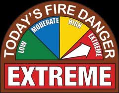
The western half of Iowa is under a Red Flag Warning this afternoon, and officials say they expect the same dangerous conditions to be present for the next days. High wind and low humidity will cause any fires that start to quickly grow out of control.
Extreme conditions mean, absolutely no outdoor burning. Permits need to be completed and signed by a Fire Chief before any controlled burns are executed during extreme conditions. There is a chance of rain Wednesday afternoon, and a better chance Wednesday night, but until rain puts a dent in the dangerous conditions, outdoor burning is prohibited.
The Freese-Notis forecast for the KJAN listening area and weather info. for Atlantic
Podcast: Play in new window | Download (1.1MB)
Subscribe: RSS
414 AM CDT MON MAR 30 2015
A RED FLAG WARNING is IN EFFECT FROM NOON TODAY UNTIL 7- PM FOR THE ENTIRE WESTERN HALF OF IOWA, INCLUDING ALL COUNTIES IN THE KJAN LISTENING AREA. THE RED FLAG WARNING IS FOR EXTREME FIRE CONDITIONS.
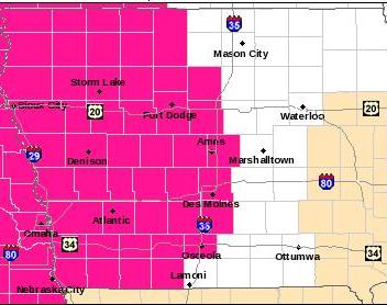
Red Flag Warning for counties shaded in pinkish-red.
* WIND…SOUTHWEST TO WEST WINDS AT 20 TO 25 MPH WITH FREQUENT GUSTS TO 30 MPH.
* RELATIVE HUMIDITY…HUMIDITY VALUES WILL DROP TO AROUND 20 PERCENT THIS AFTERNOON.
* FUEL…GRASSES REMAIN NEARLY 100 PERCENT CURED ACROSS THE WARNING AREA.
* IMPACTS…ANY FIRES THAT DEVELOP WILL HAVE THE POTENTIAL TO SPREAD VERY RAPIDLY DUE TO WINDY AND DRY CONDITIONS. ANY OUTDOOR BURNING IS HIGHLY DISCOURAGED AND SHOULD BE AVOIDED TODAY.
PRECAUTIONARY/PREPAREDNESS ACTIONS…
A RED FLAG WARNING MEANS THAT CRITICAL FIRE WEATHER CONDITIONS ARE EITHER OCCURRING NOW…OR WILL SHORTLY. A COMBINATION OF STRONG WINDS…LOW RELATIVE HUMIDITY…AND WARM TEMPERATURES WILL CREATE EXPLOSIVE FIRE GROWTH POTENTIAL.
Today: Mostly sunny, with a high near 74. Windy, with a southwest wind 5 to 10 mph increasing to 16 to 21 mph in the afternoon. Winds could gust as high as 29 mph.
Tonight: Mostly clear, with a low around 41. West southwest wind 6 to 11 mph becoming north after midnight.
Tuesday: Sunny, with a high near 74. North wind around 6 mph becoming west in the afternoon.
Tuesday Night: Mostly clear, with a low around 48. Light south wind becoming south southeast 8 to 13 mph in the evening.
Wednesday: A 30 percent chance of showers and thunderstorms after 1pm. Partly sunny, with a high near 78. Windy, with a south wind 15 to 24 mph, with gusts as high as 33 mph. New rainfall amounts of less than a tenth of an inch, except higher amounts possible in thunderstorms.
Wednesday Night: Showers and thunderstorms likely. Mostly cloudy, with a low around 47. Breezy. Chance of precipitation is 70%. New rainfall amounts between three quarters and one inch possible.
Thursday: A slight chance of showers before 1pm. Mostly sunny, with a high near 64. Chance of precipitation is 20%.


