
Today: Scattered flurries, mainly before 7am. Cloudy, then gradually becoming mostly sunny, with a high near 49. East southeast wind 5 to 14 mph.
Tonight: A slight chance of rain, mainly between 4am and 5am, then a chance of showers after 5am. Increasing clouds, with a low around 37. Breezy, with a south southeast wind 14 to 18 mph, with gusts as high as 26 mph. Chance of precipitation is 30%. New precipitation amounts of less than a tenth of an inch possible.
Sunday: A 40 percent chance of showers, mainly before 8am. Mostly cloudy, then gradually becoming sunny, with a high near 60. Windy, with a south southwest wind 15 to 25 mph becoming northwest in the afternoon. Winds could gust as high as 36 mph. New precipitation amounts of less than a tenth of an inch possible.
Sunday Night: Mostly clear, with a low around 35. Breezy, with a west northwest wind 13 to 18 mph decreasing to 6 to 11 mph after midnight. Winds could gust as high as 25 mph.
Monday: Sunny, with a high near 70. Breezy, with a southwest wind 7 to 16 mph, with gusts as high as 22 mph.
Tuesday: Sunny, with a high near 71.
Today: Increasing cloudiness. High near 45. North winds 5-10 becoming light and variable in the afternoon.
Tonight: A 50 percent chance of snow, mainly after 11pm. Low 29. SW wind around 5 mph becoming light and variable. New snow accumulation of less than a half inch possible.
Saturday: Cloudy w/a 10% chance of snow before 7am. Gradually becoming mostly sunny, with a high near 48. E/SE @ 5-15mph, with gusts as high as 20.
Sat. Night: Partly Cloudy w/a 40% chance of showers after midnight. Low 38. S @ 10-20. New precipitation amounts of less than a tenth of an inch possible.
Sunday: Partly Sunny & windy w/a 30% chance of showers. High near 58. S/SW @ 15-30. New precipitation amounts of less than a tenth of an inch possible.
Sunday Night: Mostly clear, with a low around 35.
Monday: Mostly sunny, with a high near 68.
Thursday’s High in Atlantic was 46. Our Low this morning, 19. We received a Trace of rainfall at the KJAN studios Thursday evening. Last year on this date we topped at 53 for our High and 32 was our Low. The All-Time Record High in Atlantic on March 27th, was 85 in 1895. The Record Low was 6 in 1894. Our sunrise today is at 7:11. Sunset will be at 7:39.
346 AM CDT FRI MAR 27 2015
EARLY THIS MORNING…PARTLY CLOUDY. NORTH WIND 5 TO 10 MPH.
TODAY…MOSTLY SUNNY UNTIL LATE AFTERNOON THEN BECOMING MOSTLY CLOUDY. HIGH IN THE LOWER 40S. NORTHWEST WIND NEAR 10 MPH.
TONIGHT…CLOUDY. A SLIGHT CHANCE OF LIGHT SNOW IN THE EVENING… THEN A CHANCE OF LIGHT SNOW OVERNIGHT. LOW AROUND 30. SOUTHEAST WIND NEAR 10 MPH. CHANCE OF SNOW 50 PERCENT.
SATURDAY…MOSTLY CLOUDY UNTIL LATE AFTERNOON THEN BECOMING MOSTLY SUNNY. HIGH AROUND 50. SOUTHEAST WIND 5 TO 15 MPH.
SATURDAY NIGHT…PARTLY CLOUDY THROUGH MIDNIGHT…THEN MOSTLY CLOUDY WITH A 40 PERCENT CHANCE OF LIGHT RAIN SHOWERS AFTER MIDNIGHT. LOW IN THE UPPER 30S. SOUTH WIND 10 TO 15 MPH WITH GUSTS TO AROUND 25 MPH.
SUNDAY…PARTLY SUNNY WITH A 30 PERCENT CHANCE OF LIGHT RAIN SHOWERS. BREEZY. HIGH AROUND 60. NORTHWEST WIND 10 TO 20 MPH WITH GUSTS TO AROUND 30 MPH.
MONDAY…MOSTLY SUNNY. HIGH IN THE UPPER 60S.
The Shelby County Emergency Management Agency says the Fire Danger Index will remain in the “Moderate” category, through next Monday. Officials say if you have a large burn, please notify your Fire Chief, prior to ignition. If you call the Emergency Mgmt. Agency at 712-755-2124 for assistance, if needed. 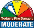
The EMA says you should “Always have a plan, Never leave a burning pile unattended , be aware of the direction and speed of the wind, and avoid smoking out neighbors or those who may have respiratory problems.”
Emergency Manager Bob Seivert says they expect the fire danger conditions to worsen next week.
The Freese-Notis forecast for the KJAN listening area and weather info. for Atlantic.

Podcast: Play in new window | Download (946.5KB)
Subscribe: RSS
404 AM CDT THU MAR 26 2015
EARLY THIS MORNING…MOSTLY CLEAR. NORTHWEST WIND 5 TO 10 MPH.
TODAY…MOSTLY SUNNY. HIGH IN THE UPPER 40S. NORTHWEST WIND 5 TO 15 MPH.
TONIGHT…MOSTLY CLOUDY THROUGH MIDNIGHT THEN BECOMING PARTLY CLOUDY. LOW IN THE LOWER 20S. NORTH WIND 5 TO 15 MPH.
FRIDAY…MOSTLY SUNNY UNTIL LATE AFTERNOON THEN BECOMING MOSTLY CLOUDY. HIGH IN THE MID 40S. NORTH WIND 5 TO 10 MPH.
FRIDAY NIGHT…CLOUDY WITH A 40 PERCENT CHANCE OF SNOW. LOW IN THE UPPER 20S. EAST WIND 5 TO 10 MPH.
SATURDAY…MOSTLY CLOUDY IN THE MORNING THEN BECOMING MOSTLY SUNNY. HIGH IN THE LOWER 50S. SOUTHEAST WIND 10 TO 15 MPH.
SATURDAY NIGHT…MOSTLY CLOUDY. A 20 PERCENT CHANCE OF RAIN AFTER MIDNIGHT. BREEZY. LOW IN THE MID 30S.
SUNDAY…PARTLY SUNNY WITH A 20 PERCENT CHANCE OF RAIN. BREEZY. HIGH AROUND 60.
The TEST TORNADO WATCH that was issued for all 99 counties in Iowa, will be allowed to expire at 11-a.m. This concludes this portion of Severe Weather Awareness week in Iowa. Thank you for your participation.
NATIONAL WEATHER SERVICE OMAHA/VALLEY NEBRASKA
1009 AM CDT WED MAR 25 2015
…THIS MESSAGE IS FOR TEST PURPOSES ONLY…
THE NATIONAL WEATHER SERVICE HAS ISSUED A TEST TORNADO WARNING FOR ALL COUNTIES IN THE KJAN LISTENING AREA.
* THIS IS A TEST MESSAGE. UNTIL 1030 AM CDT
* THIS IS A TEST MESSAGE. AT 1010 AM CDT…THIS TEST TORNADO WARNING IS BEING ISSUED AS PART OF THE SEVERE WEATHER AWARENESS WEEK ANNUAL DRILL…REPEAT DRILL. THIS ANNUAL DRILL IS THE HIGHLIGHT OF SEVERE WEATHER AWARENESS WEEK. ALL SCHOOLS…HOSPITALS… BUSINESSES…OTHER INSTITUTIONS AND THOSE AT HOME ARE URGED TO TREAT THIS AS IF IT WERE A REAL EMERGENCY. NOW IS AN EXCELLENT TIME TO PRACTICE YOUR SEVERE WEATHER EMERGENCY PLANS.
HAZARD…TEST TORNADO.
SOURCE…THIS IS A TEST.
IMPACT…THIS IS A TEST.
* THIS IS A TEST MESSAGE. THIS IS A TEST TORNADO WARNING.
PRECAUTIONARY/PREPAREDNESS ACTIONS… THIS IS A TEST. TAKE COVER NOW! MOVE TO A BASEMENT OR AN INTERIOR ROOM ON THE LOWEST FLOOR OF A STURDY BUILDING. AVOID WINDOWS. IF YOU ARE OUTDOORS…IN A MOBILE HOME…OR IN A VEHICLE…MOVE TO THE CLOSEST SUBSTANTIAL SHELTER AND PROTECT YOURSELF FROM FLYING DEBRIS. THIS IS A TEST…REPEAT TEST.
The Montgomery County Emergency Management Agency reports a ban on open burning which had been in effect since March 16th, has been lifted. The ban was rescinded due to the current wet conditions.
THE NATIONAL WEATHER SERVICE HAS ISSUED TEST TORNADO WATCH
9999 IN EFFECT UNTIL 11 AM CDT THIS MORNING FOR ALL 99 COUNTIES IN IOWA.
THIS TEST TORNADO WATCH INITIATES THE TEST WATCH PHASE OF THE IOWA SEVERE WEATHER AWARENESS WEEK’S TORNADO DRILL. REPEATING…THIS IS ONLY A TEST WATCH.
THIS IS A TEST MESSAGE. DO NOT TAKE ACTION BASED ON THIS TEST MESSAGE.


