
The Freese-Notis forecast & weather data, for Atlantic.

Podcast: Play in new window | Download (1,013.0KB)
Subscribe: RSS
415 AM CDT TUE MAR 17 2015
EARLY THIS MORNING…PARTLY CLOUDY. BREEZY. NORTH WIND 15 TO 25 MPH.
TODAY…SUNNY…BREEZY. MUCH COOLER. HIGH IN THE UPPER 40S. NORTHEAST WIND 10 TO 20 MPH WITH GUSTS TO AROUND 30 MPH.
TONIGHT…PARTLY CLOUDY. LOW IN THE UPPER 20S. EAST WIND NEAR 10 MPH.
WEDNESDAY…PARTLY SUNNY. HIGH IN THE LOWER 50S. SOUTHEAST WIND 5 TO 15 MPH. GUSTS UP TO 25 MPH IN THE AFTERNOON.
WEDNESDAY NIGHT…MOSTLY CLOUDY. LOW IN THE LOWER 30S. EAST WIND 5 TO 10 MPH.
THURSDAY…PARTLY SUNNY. HIGH IN THE LOWER 50S. SOUTHEAST WIND 5 TO 10 MPH.
THURSDAY NIGHT…MOSTLY CLOUDY. LOW IN THE MID 30S.
FRIDAY...MOSTLY SUNNY. WARMER. HIGH IN THE LOWER 60S.
This is the last Monday of winter but it’ll feel more like summer across much of Iowa with high temperatures approaching record territory. Meteorologist Brad Fillbach, at the National Weather Service, says most of the state will have highs in the 70s and 80s. “We are going to be warm today, much warmer than normal,” Fillbach says. “Our record for Des Moines today is 84 and we’re looking for highs in the lower 80s, so close, but probably not a record day.”
He says the warming trend will be boosting temperatures 20 to 30 degrees warmer than average for this date in many Iowa cities. “Normal highs for this time of the year, for the Des Moines area, are upper 40s and for the lows, you’re looking at the upper 20s, so well above normal but not quite the record levels.” A cool front is expected to drift over Iowa late tonight, bumping tomorrow’s (Tuesday) highs back down closer to normal. “We’re going to see a big change in temperatures tomorrow,” Fillbach says. “Where today, we’re lower 80s for highs and tomorrow we’re looking for lower 50s.”
Meteorologist Mindy Beerends, also at the National Weather Service, says a Red Flag Warning is posted for much of central, west-central and south-central Iowa today due to conditions raising the risk of wildfires. Beerends says, “We’re expecting gusty winds, low relative humidity and dry vegetation which is the combination factors for that Red Flag Warning and extreme fire conditions.”
Even with the big drop in high temperatures for tomorrow, Beerends says much of Iowa will still be slightly above-normal for highs for the rest of the week. Spring arrives on Friday.
(Radio Iowa)
Dry and windy conditions have prompted Emergency Management officials in Montgomery and Taylor Counties to issue a Burn Ban. The ban on opening burn in Montgomery County is in effect from Noon today (Monday), until further notice. The ban in Taylor County was ordered Friday and becomes effective today, as well.
A Red Flag warning is in effect for all of southwest and western Iowa this afternoon and this evening, for critical fire conditions (low humidity and high winds) that could create explosive fire growth.
The Freese-Notis weather forecast, and weather information for Atlantic.
Podcast: Play in new window | Download (1.5MB)
Subscribe: RSS
CRAWFORD-CARROLL-GREENE-BOONE-STORY-MARSHALL-TAMA-AUDUBON-GUTHRIE-
DALLAS-POLK-JASPER-POWESHIEK-CASS-ADAIR-MADISON-WARREN-MARION-
MAHASKA-ADAMS-UNION-CLARKE-LUCAS-MONROE-WAPELLO-TAYLOR-RINGGOLD-
DECATUR-WAYNE-APPANOOSE-DAVIS-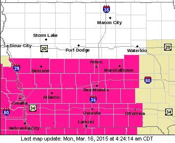
343 AM CDT MON MAR 16 2015
RED FLAG WARNING IN EFFECT FROM NOON TODAY TO 7 PM FOR EXTREME FIRE CONDITIONS….
MONONA-HARRISON-SHELBY-POTTAWATTAMIE-MILLS-MONTGOMERY-FREMONT- PAGE…RED FLAG WARNING IN EFFECT FROM NOON TODAY TO 8 PM FOR WIND AND LOW RELATIVE HUMIDITY FOR PARTS OF EASTERN NEBRASKA AND SOUTHWEST IOWA…
THE NATIONAL WEATHER SERVICE IN DES MOINES HAS ISSUED A RED FLAG WARNING FOR EXTREME FIRE CONDITIONS…WHICH IS IN EFFECT FROM NOON TODAY TO 7 PM CDT THIS EVENING.
* TIMING…HIGH FIRE WEATHER CONDITIONS WILL DEVELOP IN THE EARLY AFTERNOON AND PEAK BY MID AFTERNOON.
* WIND…WINDS WILL INCREASE TO 20 TO 25 MPH ACROSS THE SOUTH WITH GUSTS ABOVE 30 MPH AT TIMES THIS AFTERNOON.
* RELATIVE HUMIDITY…WILL DROP AS LOW AS 15 TO 20 PERCENT BY EARLY TO MID AFTERNOON.
* FUEL…90 TO 100 PERCENT CURED.
* IMPACTS…ANY FIRES THAT DEVELOP WILL HAVE THE POTENTIAL TO SPREAD MORE RAPIDLY DUE TO WINDY AND DRY CONDITIONS. ANY OUTDOOR BURNING IS HIGHLY DISCOURAGED AND SHOULD BE AVOIDED TODAY. COOLER CONDITIONS WITH HIGHER RELATIVE HUMIDITY RETURN BY TUESDAY.
PRECAUTIONARY/PREPAREDNESS ACTIONS…
A RED FLAG WARNING MEANS THAT CRITICAL FIRE WEATHER CONDITIONS ARE EITHER OCCURRING NOW…OR WILL SHORTLY. A COMBINATION OF STRONG WINDS…LOW RELATIVE HUMIDITY…AND WARM TEMPERATURES WILL CREATE EXPLOSIVE FIRE GROWTH POTENTIAL.
The National Weather Service says extreme fire danger conditions will be in place across the entire KJAN listening area from Noon today (Sunday) through late this evening, due to very low humidity (around 19-percent) and gusty southwesterly winds of 20-to 40-miles per hour. Outdoor burning is highly discouraged due to the fact fields and grassy areas are very dry and will create an effect of adding fuel to a fire.
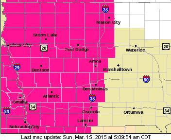
Red Flag Warning for all of southwest & western Iowa Sunday afternoon and evening
Any controlled, outdoor burns that are started may quickly become explosive and out of control, spreading very rapidly, putting lives and property in danger. A Red Flag warning means the critical fire weather condition are occurring or will occur.
In addition, a Fire Weather Watch will be in effect on Monday afternoon and evening in the southwest part of the state (Pottawattamie, Mills, Montgomery, Fremont and Page Counties), meaning critical fire weather conditions are expected. The Watch could be upgraded to a Red Flag Warning tomorrow, so stay tuned for further updates.
MONONA-HARRISON-SHELBY-POTTAWATTAMIE-MILLS-MONTGOMERY-FREMONT- PAGE COUNTIES…435 AM CDT SUN MAR 15 2015
…EXTREME FIRE DANGER TODAY… THE GRASSLAND FIRE DANGER INDEX WILL BE IN THE EXTREME CATEGORY THIS AFTERNOON. EXTREME FIRE DANGER MEANS THAT FIRES START QUICKLY…SPREAD FURIOUSLY AND BURN INTENSELY. ALL FIRES ARE POTENTIALLY SERIOUS. ALL OUTDOOR BURNING SHOULD BE AVOIDED IN AREAS WITH EXTREME FIRE DANGER.
348 AM CDT SUN MAR 15 2015 …
RED FLAG WARNING IN EFFECT FROM NOON TODAY TO 8 PM CDT THIS EVENING FOR WIND AND LOW RELATIVE HUMIDITY FOR ALL OF SOUTHWEST IOWA… …FIRE WEATHER WATCH IS ALSO POSTED FOR MONDAY AFTERNOON THROUGH MONDAY EVENING…
* WINDS…WILL BECOME SOUTHWEST 15 TO 25 MPH WITH GUSTS UP TO 35 MPH DURING THE AFTERNOON.
* RELATIVE HUMIDITY…WILL DROP INTO THE 15 TO 20 PERCENT RANGE.
* IMPACTS…ANY FIRES THAT DEVELOP WILL HAVE THE POTENTIAL SPREAD RAPIDLY AND QUICKLY BECOME OUT OF CONTROL. OUTDOOR BURNING IS NOT RECOMMENDED.
PRECAUTIONARY/PREPAREDNESS ACTIONS… A RED FLAG WARNING MEANS THAT CRITICAL FIRE WEATHER CONDITIONS ARE EITHER OCCURRING NOW…OR WILL SHORTLY. A COMBINATION OF STRONG WINDS…LOW RELATIVE HUMIDITY…AND WARM TEMPERATURES CAN CONTRIBUTE TO EXTREME FIRE BEHAVIOR. A FIRE WEATHER WATCH MEANS THAT CRITICAL FIRE WEATHER CONDITIONS ARE FORECAST TO OCCUR. LISTEN FOR LATER FORECASTS AND POSSIBLE RED FLAG WARNINGS.
346 AM CDT SUN MAR 15 2015
EARLY THIS MORNING…MOSTLY CLEAR. SOUTH WIND NEAR 5 MPH.
TODAY…RED FLAG WARNING FROM NOON UNTIL 7-PM FOR EXTREME FIRE CONDITIONS! MOSTLY SUNNY. BREEZY. HIGH IN THE MID 70S. SOUTHWEST WIND 10 TO 15 MPH WITH GUSTS TO AROUND 25 MPH INCREASING TO 20 TO 25 MPH WITH GUSTS TO AROUND 35 MPH IN THE AFTERNOON.
TONIGHT…MOSTLY CLEAR. NOT AS COOL. LOW IN THE MID 40S. SOUTHWEST WIND 10 TO 15 MPH. GUSTS UP TO 25 MPH THROUGH MIDNIGHT.
MONDAY…SUNNY. HIGH IN THE LOWER 80S. SOUTHWEST WIND 10 TO 15 MPH WITH GUSTS TO AROUND 25 MPH.
MONDAY NIGHT…PARTLY CLOUDY. BREEZY…COLDER. LOW IN THE MID 30S. NORTHWEST WIND 10 TO 15 MPH SHIFTING TO THE NORTH 15 TO 20 MPH AFTER MIDNIGHT. GUSTS UP TO 30 MPH.
TUESDAY...MOSTLY SUNNY. BREEZY. MUCH COOLER. HIGH IN THE LOWER 50S. NORTH WIND 10 TO 20 MPH. GUSTS UP TO 30 MPH IN THE MORNING.
WEDNESDAY…PARTLY SUNNY. HIGH IN THE LOWER 50S.


