
AREA COUNTIES: SAC-CRAWFORD-CARROLL-GREENE-AUDUBON-GUTHRIE-DALLAS-CASS-ADAIR-MADISON-ADAMS-UNION-TAYLOR-RINGGOLD
THE NATIONAL WEATHER SERVICE HAS ISSUED A FIRE WEATHER WATCH, IN EFFECT FROM NOON UNTIL 7-P.M., SUNDAY, FOR EXTREME FIRE CONDITIONS.
A FIRE WEATHER WATCH is in effect from Noon until 8-p.m. Sunday for FREMONT, MILLS, MONTGOMERY, PAGE, POTTAWATTAMIE & SHELBY COUNTIES.
* WIND…SOUTHWEST WINDS SUSTAINED 20 TO 30 MPH WITH GUSTS UP TO 35 MPH.
* RELATIVE HUMIDITY…20 TO 25 PERCENT…AS LOW AS 19 PERCENT. * FUEL…90 TO 100 PERCENT CURED.
* IMPACTS…ANY FIRES THAT DEVELOP WILL HAVE THE POTENTIAL TO SPREAD RAPIDLY. OUTDOOR BURNING IS NOT RECOMMENDED.
PRECAUTIONARY/PREPAREDNESS ACTIONS… A FIRE WEATHER WATCH MEANS THAT CRITICAL FIRE WEATHER CONDITIONS ARE FORECAST TO OCCUR. LISTEN FOR LATER FORECASTS AND POSSIBLE RED FLAG WARNINGS.
Skyscan Forecast Saturday, March 14, 2015
Today: Sunny, with a high near 65. North wind 5 to 10 mph.
Tonight: Mostly clear, with a low around 37. Northwest wind 5 to 10 mph becoming calm.

Podcast: Play in new window | Download (394.6KB)
Subscribe: RSS
Today: Mostly sunny. High 68. S/SW winds becoming N/NW this afternoon @ 10-20.
Tonight: Mostly clear. Low around 30. N @ 5-10.
Saturday: Sunny, with a high near 64. North winds becoming variable @ 5-10mph.
Sat. Night: Clear, with a low around 36.
Sunday: Sunny & windy, with a high near 75. S @ 15-30mph.
Sunday Night: Mostly clear & windy, with a low around 44.
Monday: Partly Cloudy & breezy. High near 68. Breezy.
********
Thursday’s High in Atlantic was 73. Our Low this morning, 31. Last year on this date we reached 62 for a High, and 22 was the Low. The All-time record High in Atlantic on March 13th, was 79 in 2012. The Record Low was -11 in 1948 and 1975.
Sunrise is at 7:36 and Sunset at 7:24.
315 AM CDT FRI MAR 13 2015
EARLY THIS MORNING…MOSTLY CLEAR. SOUTH WIND 5 TO 10 MPH.
TODAY…SUNNY. HIGH AROUND 70. SOUTHWEST WIND 5 TO 10 MPH SHIFTING TO THE NORTH 10 TO 15 MPH WITH GUSTS TO AROUND 25 MPH IN THE AFTERNOON.
TONIGHT…PARTLY CLOUDY. LOW IN THE UPPER 30S. NORTH WIND 10 TO 15 MPH.
SATURDAY…SUNNY. HIGH IN THE LOWER 60S. NORTH WIND 5 TO 15 MPH.
SATURDAY NIGHT…CLEAR. LOW IN THE MID 30S. NORTHEAST WIND NEAR 5 MPH SHIFTING TO THE SOUTH AFTER MIDNIGHT.
SUNDAY...SUNNY…BREEZY. HIGH IN THE UPPER 60S. SOUTH WIND 5 TO 15 MPH SHIFTING TO THE SOUTHWEST 15 TO 20 MPH IN THE AFTERNOON. GUSTS UP TO 30 MPH.
SUNDAY NIGHT…PARTLY CLOUDY. LOW IN THE MID 40S.
MONDAY...MOSTLY SUNNY. HIGH IN THE UPPER 60S.
The Shelby County Emergency Management Agency/911 is asking all Fire Departments in the County to immediately place the Fire Danger Rating Boards in the EXTREME category. The Increase in Fire Danger is due to No expected precipitation in next four days, large volume of dead plant material, low humidity’s, increased temperature’s, predicted gusting winds to 29MPH, and limited field access due to thawing conditions.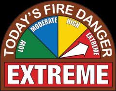
Fire Behavior predictions in these conditions are as follows: fire spread between 7 to 10 MPH, with flame lengths approximately 30’ in length at the front of the fire. Fires that start in these conditions can easily overtake and trap you. Firefighters are at a high risk also due to traction issues off road.
Shelby County Ordinance NO. 2012-1 Local Burning Ban Ordinance allows citations to be issued during these conditions. A violation of this ordinance is punishable by a minimum fine of $100 for an individual or $500 for an organization, not to exceed $1000. The violator may also be liable for additional reasonable restitution.
**Fire Weather Watch for wind & low humidity this afternoon for Harrison, Shelby, Pottawattamie, Mills, Montgomery, Fremont & Page Counties**RED FLAG WARNING this afternoon for extreme fire conditions in Sac, Crawford, and Carroll Counties.**
Today: Sunny & windy. High near 73. S @ 10-20 w/gusts to near 30.
Tonight: Partly cloudy. Low around 40. S/SE @ 5-10.
Friday: Partly Cloudy & breezy. High near 65. SW winds becoming NE @ 10-25.
Friday Night: Partly cloudy, with a low around 38. N @ 10-20.
Saturday: Partly Cloudy. High near 60. North wind 5 to 10 mph.
Saturday Night: Mostly clear, with a low around 37.
Sunday: Partly Cloudy & breezy. High near 72.
********
Wednesday’s High in Atlantic was 66. Our 24-hour Low (ending at 7-am today) is 32. Last year on this date we reached 45 for our High and 22 was the Low. The All-Time Record High in Atlantic on March 12th, was 74 in 1938. The Record Low was -21 in 1998. Sunrise today is at 7:37, Sunset at 7:23.
HARRISON-SHELBY-POTTAWATTAMIE-MILLS-MONTGOMERY-FREMONT-PAGE-Counties
329 AM CDT THU MAR 12 2015
THE NATIONAL WEATHER SERVICE IN OMAHA/VALLEY HAS ISSUED A FIRE WEATHER WATCH FOR WIND AND LOW RELATIVE HUMIDITY…WHICH IS IN EFFECT FROM 1 PM CDT THIS AFTERNOON THROUGH THIS EVENING.
* WINDS…SOUTH 10 TO 20 MPH WITH GUSTS UP TO 30 MPH.
* RELATIVE HUMIDITY…AS LOW AS 20 PERCENT.
* IMPACTS…THE COMBINATION OF STRONG WINDS…LOW RELATIVE HUMIDITY…AND WARM TEMPERATURES CAN CONTRIBUTE TO EXTREME FIRE BEHAVIOR.
PRECAUTIONARY/PREPAREDNESS ACTIONS…
A FIRE WEATHER WATCH MEANS THAT CRITICAL FIRE WEATHER CONDITIONS ARE FORECAST TO OCCUR. LISTEN FOR LATER FORECASTS AND POSSIBLE RED FLAG WARNINGS.
SAC-CRAWFORD-CARROLL-MONONA COUNTIES
350 AM CDT THU MAR 12 2015
THE NATIONAL WEATHER SERVICE IN DES MOINES HAS ISSUED A RED FLAG WARNING FOR EXTREME FIRE CONDITIONS…WHICH IS IN EFFECT FROM NOON TODAY TO 6 PM CDT THIS EVENING. THE FIRE WEATHER WATCH IS NO LONGER IN EFFECT.
* WIND…INCREASING TO SOUTH 25 TO 30 MPH BY AFTERNOON
* RELATIVE HUMIDITY…AS LOW AS 25 TO 35 PERCENT IN THE AFTERNOON.
* IMPACTS…FUELS ARE VERY DRY ACROSS THE AREA. ANY FIRES THAT DEVELOP WILL HAVE THE POTENTIAL TO SPREAD RAPIDLY. OUTDOOR BURNING IS NOT RECOMMENDED ACROSS THE REGION.
* TIMING…WINDS WILL INCREASE AFTER NOON WITH PEAK WINDS BETWEEN 1 PM AND 5 PM THIS AFTERNOON. RELATIVE HUMIDITY WILL ALSO BE AT ITS LOWEST DURING THIS TIME.
* FUEL…FINE FUELS SUCH AS GRASSES AND BRUSH ARE VERY DRY AND WILL BURN EASILY.
PRECAUTIONARY/PREPAREDNESS ACTIONS…
A RED FLAG WARNING MEANS THAT CRITICAL FIRE WEATHER CONDITIONS ARE EITHER OCCURRING NOW…OR WILL SHORTLY. A COMBINATION OF STRONG WINDS…LOW RELATIVE HUMIDITY…AND WARM TEMPERATURES WILL CREATE EXPLOSIVE FIRE GROWTH POTENTIAL.
330 AM CDT THU MAR 12 2015
EARLY THIS MORNING…MOSTLY CLEAR. SOUTHEAST WIND 5 TO 10 MPH.
TODAY…SUNNY…BREEZY. HIGH IN THE LOWER 70S. SOUTH WIND 10 TO 15 MPH INCREASING TO 15 TO 25 MPH IN THE AFTERNOON.
TONIGHT…PARTLY CLOUDY. LOW IN THE LOWER 40S. SOUTH WIND 5 TO 15 MPH.
FRIDAY...MOSTLY SUNNY. BREEZY. HIGH IN THE UPPER 60S. WEST WIND 5 TO 10 MPH INCREASING TO NORTH 15 TO 20 MPH IN THE AFTERNOON.
FRIDAY NIGHT…PARTLY CLOUDY. LOW IN THE UPPER 30S. NORTH WIND 10 TO 15 MPH. GUSTS UP TO 25 MPH THROUGH MIDNIGHT.
SATURDAY…SUNNY. HIGH IN THE LOWER 60S. NORTH WIND 5 TO 15 MPH.
SATURDAY NIGHT…MOSTLY CLEAR. LOW IN THE UPPER 30S.
SUNDAY…SUNNY. HIGH IN THE LOWER 70S.
AREA COUNTIES: SAC-CRAWFORD-CARROLL-MONONA
432 PM CDT WED MAR 11 2015
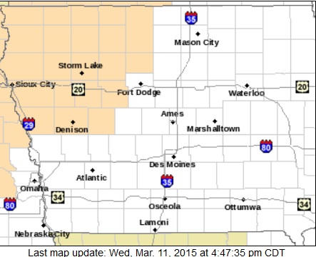
Counties in Peach color are included in the Fire Weather Watch
THE NATIONAL WEATHER SERVICE HAS ISSUED A FIRE WEATHER WATCH FOR EXTREME FIRE CONDITIONS…WHICH IS IN EFFECT THURSDAY AFTERNOON FOR PARTS OF WESTERN/NW IA AND NORTHEAST NEBRASKA. THE WATCH IS IN EFFECT FROM NOON THROUGH 7-PM FOR MOST COUNTIES AFFECTED.
* WIND…SOUTH 20 TO 30 MPH
* RELATIVE HUMIDITY…20 TO 35 PERCENT
* IMPACTS…FUELS ARE VERY DRY ACROSS THE AREA. ANY FIRES THAT DEVELOP WILL HAVE THE POTENTIAL TO SPREAD RAPIDLY. OUTDOOR BURNING IS NOT RECOMMENDED.
PRECAUTIONARY/PREPAREDNESS ACTIONS…
A FIRE WEATHER WATCH MEANS THAT CRITICAL FIRE WEATHER CONDITIONS ARE FORECAST TO OCCUR. LISTEN FOR LATER FORECASTS AND POSSIBLE RED FLAG WARNINGS.


