
SAC-CRAWFORD-CARROLL-AUDUBON-GUTHRIE-DALLAS COUNTIES…
738 AM CST TUE MAR 3 2015
…FREEZING DRIZZLE WILL CREATE LOCALIZED SLICK AREAS THIS MORNING...
FREEZING DRIZZLE HAS OVERSPREAD MUCH OF CENTRAL AND WEST CENTRAL IOWA THIS MORNING. ACCUMULATIONS ARE EXPECTED TO BE LIGHT BUT WILL BE ENOUGH TO DEVELOP A GLAZE ON UNTREATED ROADWAYS AND WINDSHIELDS. IF YOU ARE OUT DRIVING THIS MORNING…PLEASE DRIVE WITH CAUTION AND BE PREPARED FOR SLICK ROADS. TEMPERATURES SHOULD WARM FROM SOUTH TO NORTH DURING THE MORNING AND GRADUALLY BRING AN
END TO THE FREEZING DRIZZLE THREAT.
Today: Cloudy & windy, w/a 30% chance of rain, freezing rain, and sleet before noon, then a slight chance of rain and snow between noon and 1pm. High near 36 early, w/temps dropping during the day. S winds @ 10-20 becoming NW this afternoon & gusting up to near 40mph. Little or no snow and sleet accumulation expected.
Tonight: Mostly cloudy w/a chance of flurries. Low around 5. N/NW @ 15-30. Wind chill values as low as -5.
Wednesday: P/Cldy. Highs around 20. N/NW @ 10-20. Wind chill values as low as -5.
Wed. Night: Mostly clear, with a low around 0.
Thursday: P/Cldy. High near 27. SW @ 5-10.
Thu. Night: Mostly clear, with a low around 20.
Friday: P/Cldy & breezy. High near 47.
Monday’s High in Atlantic was 42. Our 24-hour Low ending today at 7-a.m. was 15. We received a Trace of precipitation early this morning at the KJAN studios. Last year on this date we topped at 14 for a High and -11 was the Low. The All-Time Record High in Atlantic on March 3rd was 79 in 1983, the Record Low was -11 in 2014.
CRAWFORD-CARROLL-AUDUBON-GUTHRIE-DALLAS-MADISON COUNTIES…
545 AM CST TUE MAR 3 2015
…WINTER WEATHER ADVISORY IS CANCELLED…
THE NATIONAL WEATHER SERVICE IN DES MOINES HAS CANCELLED THE WINTER WEATHER ADVISORY.
PRECIPITATION HAS MOVED OUT OF THE ADVISORY AREA. HOWEVER…FREEZING RAIN WAS REPORTED ACROSS MUCH OF THE AREA WITH MANY ROADWAYS AND WALKWAYS BECOMING ICE COVERED. CONTINUE TO USE CAUTION WHILE TRAVELING AS ROADS REMAIN SLICK.
MONONA-HARRISON-SHELBY-POTTAWATTAMIE-MILLS-MONTGOMERY-FREMONT-
PAGE COUNTIES; 520 AM CST TUE MAR 3 2015
…FREEZING DRIZZLE POSSIBLE THIS MORNING…
AREAS OF DRIZZLE WILL OCCUR THIS MORNING…WITH TEMPERATURES RANGING FROM 30 TO 33 DEGREES. THUS…BE PREPARED FOR SOME SLICK SPOTS ON UNTREATED ROADWAYS…AND ESPECIALLY ON BRIDGES AND OVERPASSES AND IN LOW LYING AREAS. SIDEWALKS AND PARKING LOTS COULD ALSO BECOME SLICK.
State Climatologist Harry Hillaker says February will goes into the record books in the top ten in both cold and snow. Hillaker says the persistent cold is probably the thing that stands out the most about the month. “Actually only had five days where the statewide average temperature was above normal,” Hillaker says. Those were five consecutive days above normal from February 6th through the 10th. Temperatures really dropped at the end of the month.
“Our lowest temperatures of the month — actually for the whole winter — came on the last two days of February. Stanley, in Buchanan County in northeast Iowa got down to an official minus thirty degrees the morning of February 27, that’s actual temperature, not windchill,” Hillaker says, “and the next morning, Elkader in Clayton County, also got down to minus 30 degrees.” February was just a little snowier than normal.
Hillaker says most of the snow came in one storm at the beginning of the month, but overall it was the ninth snowiest and ninth coldest February. The state has kept weather records for 143 years. Overall the winter hasn’t been anything too out of the ordinary. “We are running just a little bit above normal in the snowfall, again thanks in large part to February,” Hillaker says. “So far this winter, about two-point-seven inches above normal for snowfall, which would put us at the 45th snowiest winter.”
Hillaker says winter’s worst is probably past us now as the days get longer with more sunlight heading into March.
(Radio Iowa)
CRAWFORD-CARROLL-AUDUBON-GUTHRIE- DALLAS-MADISON COUNTIES…
A WINTER WEATHER ADVISORY REMAINS IN EFFECT UNTIL 8 AM TUESDAY…
* STORM TOTAL SNOW/ICE ACCUMULATIONS…SNOW ACCUMULATIONS WILL VARY FROM LITTLE TO NONE TOWARD THE MISSOURI BORDER…TO LESS THAN AN INCH FARTHER NORTH TOWARD HIGHWAY 30. ANY ICE ACCUMULATIONS WILL BE MINOR…ONLY A COUPLE HUNDREDTHS OF AN INCH AT WORST.
* IMPACTS…ALTHOUGH ONLY MINOR ICE AND SNOW ACCUMULATIONS ARE ANTICIPATED…THE WINTERY MIX MAY PRODUCE HAZARDOUS TRAVEL EARLY TUESDAY…INCLUDING THE MORNING COMMUTE.
Today: A chance of rain, freezing rain, and sleet before noon, then a slight chance of rain and snow between noon and 1pm. Cloudy, with a high near 36. Windy, with a south wind 11 to 16 mph becoming northwest 21 to 26 mph in the afternoon. Winds could gust as high as 37 mph. Chance of precipitation is 30%. Little or no snow and sleet accumulation expected.
Tonight: Mostly cloudy, with a low around 9. Wind chill values as low as -5. Windy, with a north northwest wind 18 to 23 mph decreasing to 11 to 16 mph after midnight. Winds could gust as high as 32 mph.
Wednesday: Mostly sunny, with a high near 22. Wind chill values as low as -5. Blustery, with a north northwest wind 10 to 16 mph.
Wednesday Night: Mostly clear, with a low around 0. Wind chill values as low as -10. North wind 5 to 13 mph.
Thursday: Sunny, with a high near 29. Light and variable wind becoming southwest 5 to 10 mph in the morning.
Thursday Night: Mostly clear, with a low around 20.
Friday: Mostly sunny, with a high near 47. Breezy.
AREA COUNTIES: CRAWFORD-CARROLL-AUDUBON-GUTHRIE-DALLAS-MADISON-
WINTER WEATHER ADVISORY IN EFFECT FROM MIDNIGHT TONIGHT TO 8 AM CST TUESDAY…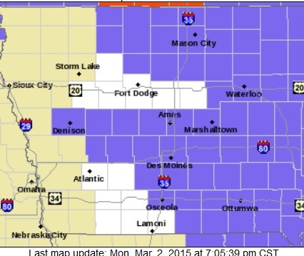
THE NATIONAL WEATHER SERVICE IN DES MOINES HAS ISSUED A WINTER WEATHER ADVISORY FOR LIGHT FREEZING RAIN…SLEET OR SNOW…WHICH IS IN EFFECT FROM MIDNIGHT TONIGHT TO 8 AM CST TUESDAY.
* TIMING…INTERMITTENT LIGHT FREEZING RAIN…SLEET AND SNOW ARE ANTICIPATED EARLY TUESDAY MORNING BEFORE TRANSITIONING TO MAINLY LIGHT RAIN OR DRIZZLE SHORTLY AFTER DAYBREAK. THE PRECIPITATION TYPE MAY BE QUITE VARIABLE FROM TIME TO TIME.
* STORM TOTAL SNOW/ICE ACCUMULATIONS…SNOW ACCUMULATIONS WILL VARY FROM LITTLE TO NONE TOWARD THE MISSOURI BORDER…TO LESS THAN AN INCH FARTHER NORTH TOWARD HIGHWAY 30. ANY ICE ACCUMULATIONS WILL BE MINOR…ONLY A FEW HUNDRETHS OF AN INCH AT WORST.
* IMPACTS…ALTHOUGH ONLY MINOR ICE AND SNOW ACCUMULATIONS ARE ANTICIPATED…THE WINTRY MIX MAY PRODUCE HAZARDOUS TRAVEL EARLY TUESDAY…INCLUDING THE MORNING COMMUTE.
PRECAUTIONARY/PREPAREDNESS ACTIONS…
A WINTER WEATHER ADVISORY MEANS THAT PERIODS OF SNOW…SLEET…OR FREEZING RAIN WILL CAUSE TRAVEL DIFFICULTIES. BE PREPARED FOR SLIPPERY ROADS AND LIMITED VISIBILITIES…AND USE CAUTION WHILE DRIVING.
The National Weather Service in Des Moines says a large storm system will begin to affect central Iowa tonight, persisting into Tuesday.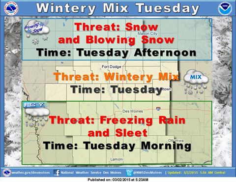 The system will bring chances for a wintery mix across much of the area.
In the south, freezing rain and sleet will be possible tonight and into the early morning hours Tuesday, with icy conditions possibly affecting morning travel Tuesday. Precipitation will gradually turn to rain as temperatures warm Tuesday.
Across the north, snow will be possible with light to moderate accumulations. Winds will increase Tuesday afternoon which may combine with falling and fresh fallen snow to create hazardous travel conditions Tuesday.
Continue to monitor the forecast for updates into Tuesday as threat areas become more refined.
Today: P/Cldy to Cldy. High near 35. NW winds becoming S/SE @ 5-10. Wind chill values as low as 10.
Tonight: Cldy w/a chance of rain, snow, freezing rain, and sleet. Low around 30. Se @ 10-20. New ice accumulation of less than a 0.1 of an inch possible. Little or no snow and sleet accumulation expected.
Tuesday: Rain likely before noon, then a slight chance of snow between noon and 3pm. Temperature rising to near 34 by 9am, then falling to around 26 during the remainder of the day. S winds becoming N/NW @ 15-35. Less than 1” snow expected.
Tue. Night: Mostly cloudy & windy, with a low around 7. WN/NW @ 15-30.
Wednesday: P/Cldy & blustery. High around 15. NW @ 15-25.
Wednesday Night: Mostly clear, with a low around 0.
Thursday: P/Cldy. High near 27.
Sunday’s High in Atlantic was 38. Our Low this morning, 12. Last year on this date we had a High of -2 and a Low of -12. The All-Time record High in Atlantic on March 2nd was 76 in 1992, the Record Low was -12, in 2014. Sunrise today is at 6:54, Sunset at 6:11.


