
Today: Mostly cloudy this morning, then gradually becoming sunny, with a high near 57. Breezy, with a west northwest wind 7 to 16 mph, with gusts as high as 21 mph.
Tonight: Mostly clear, with a low around 29. Calm wind becoming northeast around 5 mph after midnight.
Monday: Mostly sunny, with a high near 54. East wind 6 to 15 mph, with gusts as high as 21 mph.
Monday Night: A 20 percent chance of showers after midnight. Increasing clouds, with a low around 38. Southeast wind around 11 mph, with gusts as high as 21 mph.
Tuesday: A chance of showers, with thunderstorms also possible after noon. Cloudy, with a high near 63. Breezy, with a south southeast wind 11 to 18 mph, with gusts as high as 26 mph. Chance of precipitation is 50%. New rainfall amounts of less than a tenth of an inch, except higher amounts possible in thunderstorms.
Tuesday Night: A 20 percent chance of showers and thunderstorms before midnight. Cloudy, with a low around 55.
Wednesday: Mostly cloudy, with a high near 72. Windy.
Saturday’s High in Atlantic was 52. The Low was 34. Last year on this date, the High was 68 and the Low was 40. The Record High in Atlantic on Nov. 6th was 77 in 1915, and the Record Low was 9 in 1991.
Today: Rain/possible snow flurries this morning; Becoming sunny this afternoon. High 50. N @ 15.
Tonight: P/Cldy. Low 41. SW @ 15-20.
Tomorrow: P/Cldy. High 58. NW @ 15.
Monday: Mo. Sunny. High 54. E @ 10-15.
Tuesday: Mo. Cldy w/a 50% chance of afternoon rain. High 51. SE @ 10-20.
Friday’s High in Atlantic was 40. Our Low was 37. We received .67″ of an inch of rain Friday through early today. Last year on this date the High in Atlantic was 61 and the Low was 39. The Record High on this date was 79 in 2020. The Record Low was 3 in 1951.
(Radio Iowa) – Parts of western Iowa could get snow late tonight (Friday) and into Saturday, with some forecast models showing the potential for several inches of accumulation. Conditions can change quickly and Iowa Department of Transportation spokesman Pete Hjelmstad says if there’s frost or snow covering your vehicle’s windows, it should be a no-brainer that you clear them off before trying to drive. “Unfortunately, many times, when I’m driving to work at 6:45 in the morning and I see people driving down the road and I really don’t know how they can see when I see their windshields,” Hjelmstad says. “You also see reports on social media a lot of times of the State Patrol or Motor Vehicle Enforcement or county sheriff’s or local city police departments pulling people over because their windows are not cleaned off.”
Hjelmstad says Iowans may need to brush up on their winter driving skills. No matter what the weather, drivers need to slow down, which is something he says hasn’t changed since the early days of the pandemic. “The theory is that there was so little traffic on the roads, and the roads were wide open, that people just felt they could drive fast and they have not changed their habits. There’s a lot of crashes because of speeding,” Hjelmstad says. “You are seeing a lot of times law enforcement posting pictures of somebody pulled over and their radar, and the radar is triple-digits. It’s beyond ridiculous.” 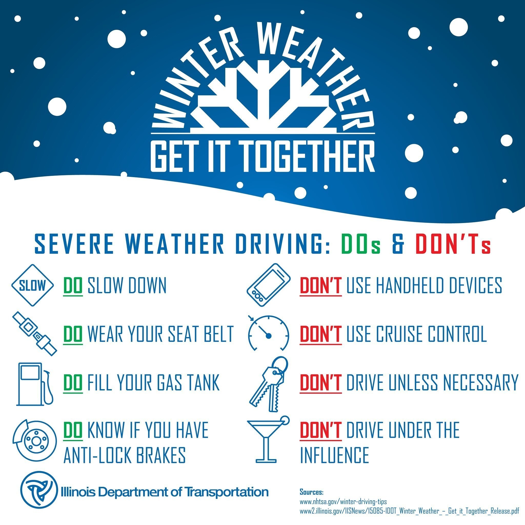
He says motorists would be wise to look before they leap into the driver’s seat. “Know what you’re getting into, check the weather forecast, check the 511 app,” he says. “Being prepared is knowing what’s out there.” Hjelmstad also suggests Iowans keep a winter survival kit in their vehicles.
(Des Moines, Iowa) – The latest drought monitor released Thursday morning, shows just how badly Iowa could use rain. Right now, the entire state remains in some type of drought. Nearly 89% of Iowa is moderately dry with nearly 11% in extreme drought, that latter of which is showing up in northwest and western areas, and is up from seven-percent just last week. Cass and most contiguous Counties are shown to be in a Moderate drought, with parts of Shelby and Montgomery in a severe drought, along with Harrison, Mills, Fremont and Page Counties. 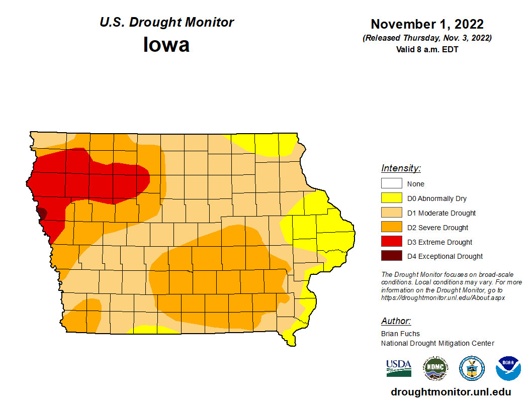
This morning: A 50 percent chance of rain and thunderstorms. Cloudy, with a steady temperature around 44. North wind around 11 mph. New rainfall amounts of less than a tenth of an inch, except higher amounts possible in thunderstorms.
Today: Rain and possibly a thunderstorm before 4pm, then showers, mainly after 4pm. Temperature falling to around 40 by 1pm. North wind 11 to 14 mph, with gusts as high as 24 mph. Chance of precipitation is 90%. New rainfall amounts between a quarter and half of an inch possible.
Tonight: Showers. Low around 33. North wind 13 to 15 mph, with gusts as high as 24 mph. Chance of precipitation is 100%. New precipitation amounts between a half and three quarters of an inch possible.
Saturday: Rain and snow likely before 11am, then a slight chance of rain between 11am and noon. Cloudy through mid morning, then gradual clearing, with a high near 47. Breezy, with a northwest wind 11 to 16 mph becoming southwest in the afternoon. Winds could gust as high as 26 mph. Chance of precipitation is 60%. New snow accumulation of less than a half inch possible.
Sunday: Mostly sunny, with a high near 56.
Monday: Mostly sunny, with a high near 54. Breezy.
Thursday’s High in Atlantic was 73. Our Low this morning, 40. As of 7-a.m. (the end of a 24-hour cycle) we had received .04″ of rain. Last year on this date the High in Atlantic was 55 and the Low was 36. The Record High on this date was 75 in 1909 & 1978. The Record Low was -1 in 1991.
Today: Partly cloudy & windy. High 74. S/SW @ 15-30 mph.
Tonight: P/cldy to cldy w/showers & possible tstrms late. Low 46. S-NW @ 10-20.
Tomorrow: Mo. Cldy w/light rain. High 48. N @ 15-25.
Saturday: Light rain/snow mixed at times. Becoming P/Cldy. High 48.
Sunday: P/cldy. High 62.
Wednesday’s High in Atlantic was 76 (1 degree shy of the record). Our Low was 54. Last year on this date the High in Atlantic was 46 and the Low was 19. The Record High on this date was 78 in 2020. The Record Low was 6 in 1966.
(Radio Iowa) – October wrapped up as one of Iowa’s 20 driest Octobers in 150 years of record keeping. State climatologist Justin Glisan says the northwest and central regions of the state were as much as two-and-a-half inches below normal for rainfall for the month. “We’re starting to trend down into the driest part of the year which is December, January and February,” Glisan says, “but if we look at the statewide average total, we were just under an inch, and that’s about one-and-three-quarter inches below average across the state.”
Temperatures were widely varied for the month, with some days in the 90s for highs and some nights falling well below freezing and into the teens. November is starting off warm but the short-term forecasts indicate that won’t last but another day or so. “Outlooks are showing us a trend towards cooler-than-average temperatures but also a wet signal is building in,” Glisan says, “which is good in terms of replenishing at least some subsoil moisture for the next growing season, given how pervasive drought has been across the state.”
Glisan says it appears the weather pattern known as La Nina will continue into the winter ahead for a third straight year, which is unusual. “Typical La Nina years, historically for the state of Iowa, we’ve seen above-average snowpack,” Glisan says. “If we look at the outlooks, we’re not getting a clear signal on precipitation right now, but we are getting a slightly elevated signal for colder-than-average temperatures in that December, January, February timeframe.” La Nina happens when cold sea surface temperatures in the Pacific impact where the storm track sets up across the country. With the wide temperature swings during October, Glisan says it all balanced out as the average temperature for the month was less than one degree below normal.
The month of October, here in Atlantic, was both warmer and cooler than average, and much drier than it should have been. Weather records compiled at KJAN (the OFFICIAL National Weather Service data site for Atlantic) show we were slightly more than 2-degrees warmer than the average of 64.1-degrees. We departed with an average of 67.3 degrees. On the Low side, we came in at 31.5-degrees for an average, which was seven-degrees cooler than average.
Rainfall, typically 2.76-inches in October, came in a little more than three-quarters of an inch, at .79.”
Here’s what the stats normally are for November:
Today: **ELEVATED FIRE DANGER** Sunny & windy. High near 74. S winds @10-20 mph w/gusts to near 40 this afternoon.
Tonight: Mostly clear & breezy, with a low around 55. S @ 15-30 mph.
Tomorrow: A slight chance of rain in the afternoon. Partly sunny. High 72. S @ 15-35 mph.
Friday: Showers and possibly a thunderstorm. High near 55. New rainfall amounts between a half and three quarters of an inch possible.
Saturday: A 50 percent chance of showers. Partly sunny, with a high near 50.
Tuesday’s High in Atlantic was 78. That tied the Record High set in 1933! Our Low was 32. Last year on this date the High in Atlantic was 46 and the Low was 19. The Record High on this date was 77 in 1965 & 2015. The Record Low was 5 in 1966.
Sac-Crawford-Carroll-Audubon-Guthrie-Cass Counties…Elevated Fire Weather Danger and Strong Winds in Western Iowa Today…
South winds increase by late morning through the afternoon with gusts in excess of 40 mph likely at times. This may blow around loose, lightweight objects and create difficult driving conditions for high profile vehicles, especially on west to east
routes. The strong winds combined with low RH values in the 30 percent range will lead to fire weather concerns this afternoon. Any fire starts will have the potential to become out of control and spread quickly.
Scattered field and ditch fires occurred Tuesday afternoon in southwest Iowa, including a corn field off 720th, between Seattle and Tucson Roads. Massena and Cumberland Fire crews were dispatched to the scene at around 4:57-p.m. Another fire was reported in Harrison County.
As reminder, Burn Bans are in effect for nine southwest Iowa Counties until further notice.
AMES – As Iowa’s annual harvest wraps up across the state, the Iowa Department of Natural Resources (DNR) encourages farmers to get reacquainted with fire prevention practices to keep the farm ‘firewise.’ This has been an extended drought year, particularly in the western part of the state. The following simple steps for a safer harvest can save time and money.
Check that all fire extinguishers carried on the machinery are fully charged with loose powder inside. If the powder is not loose, remove the extinguisher from its bracket then thump the canister with a rubber hammer until the powder moves when shaken.
Make sure the size of the extinguisher is appropriate for the size of the machinery. You may need larger and/or additional extinguishers. Also make sure you have the correct extinguisher for the type of fire to be extinguished. There are two types of extinguishers, the powder extinguisher for electrical and petroleum-based fires and the water extinguisher for vegetative fires. You may need to carry both kinds of extinguishers.
Planning proper hay storage is crucial. Store hay away from combustibles such as gasoline, fertilizers and pesticides, as well as open burning areas like burn barrels, brush piles and vegetative burning. Arrange round bales in groups of 10 or fewer and place at least 100 feet away from structures. Leave 30 feet of mowed grass, bare ground or rock between the bale groups, creating a solid fire break.
Many hay fires occur by spontaneous combustion of moist hay, usually within six weeks after baling. Plan to bale hay at its driest stage and do not bale in the morning dew or too soon after a rain.
Check stored hay frequently for hot hay or an internal hay fire. Be aware of a caramel or strong burning odor, a visible vapor or smoke, a strong musty smell, and/or hay that is hot when touched. If any of these occur, call the fire department immediately and do not move the hay. Moving it exposes overheated or smoldering hay to oxygen, speeding the fire.
To help control field fires until firefighters arrive, remain calm and act swiftly. Quickly disk a fire break approximately 15 feet wide around the fire. Be cautious when doing this as smoke will starve and stall a motor and will make hazards and bystanders difficult to see. To assist with a structural fire, make sure there are no flammable objects nearby and if the circuit panel is safely accessible, turn off the building’s electricity. If time allows, evacuate any livestock to a distant pasture. If possible, spray high-pressure water on any surrounding vegetation or structures, discouraging spreading embers. Do not take risks.
After using any equipment to fight a fire, check air filters, ledges, nooks and crannies for burning debris. For more detailed information, visit www.iowadnr.gov/Conservation/Forestry/Fire-Prevention/Fire-Protection-Prevention.
Remember, in a fire emergency, call 911 immediately. Do not wait until all your means of fighting the fire are exhausted. Every minute impacts your losses.


