
(Today) Thanksgiving Day: Patchy fog before 9am. Otherwise, cloudy through mid morning, then gradual clearing, with a high near 46. Southwest wind 5 to 14 mph becoming north northwest in the afternoon. Winds could gust as high as 22 mph.
Tonight: Mostly clear, with a low around 25. North northwest wind 5 to 9 mph becoming light northwest after midnight.
Friday: Sunny, with a high near 50. Calm wind becoming west southwest 5 to 8 mph in the morning.
Saturday: Mostly sunny, with a high near 53.
Saturday Night: A chance of rain before 3am, then a chance of rain and snow. Cloudy, with a low around 29. Chance of precipitation is 40%.
Sunday: Mostly sunny, with a high near 44.
Wednesday’s High in Atlantic was 60. Our Low was 20. Last year on this date the High in Atlantic was 54 and the Low was 18. The Record High on this date was 68 in 2011. The Record Low was -2 in 1898.
Today: Areas of fog this morning; Partly cloudy. High 57. S @ 10-20.
Tonight: Mostly cloudy w/fog and drizzle, late. Low 37. S @ 5-10.
Thanksgiving Day (Thursday): Mo. Cldy w/morning fog & drizzle. High 63. NW @ 10-20.
Friday: P/Cldy. High 49.
Saturday: P/Cldy. High 51.
Tuesday’s High in Atlantic was 60. Our Low was 15. Last year on this date the High in Atlantic was 63 and the Low was 29. The Record High on this date was 84 in 1953. The Record Low was -6 in 1898.
Today: Mostly sunny. High 52. SW @ 10-15.
Tonight: Fair to P/Cldy. Low 26. S @ 5-10.
Tomorrow: P/Cldy. High 54. SW @ 10-20.
Thanksgiving Day: Mostly cloudy w/a chance of drizzle or sprinkles in the morning. High 43.
Friday: P/Cldy. High 48.
Monday’s High in Atlantic was 52. Our Low was 15. Last year on this date the High in Atlantic was 45 and the Low was 23. The Record High on this date was 69 in 1966. The Record Low was -10 in 1937.
(Radio Iowa) – Looks like we’ll have a brown Thanksgiving. National Weather Service meteorologist, Dylan Dobson, says the rest of our snow should melt away by Thursday. “So, we’re gonna expect it to warm up here through the week, with the warmest day actually being Wednesday. Highs on Wednesday we’ll be in the low 50s,” he says. Dobson says Thanksgiving Day will cool off some.
“Just a little bit not a whole lot with highs on Thursday being in the mid 40s, and then Friday and also in the mid 40s,” Dobson says. “But then we’ll warm back up through the weekend back into those more seasonal 40s and 50s.” Most of the state should see good driving conditions.
“We might have a few chances for some scattered showers — mainly in eastern and southern Iowa — but other than that it should be fairly quiet for Thanksgiving this year,” he says. Dobson says the melting of the snow we had helps the temperatures warm up.
(Radio Iowa) – The La Nina weather pattern will influence Iowa’s climate for the winter ahead, likely bringing wetter and colder-than-normal temperatures. It’s the third winter in a row for La Nina, but observers do -not- expect it to make a fourth appearance. Meteorologist Doug Kluck, the climate services director for the central region of the National Weather Service, says they see La Nina fading early next year. “As time goes on, into the spring, we see a lessening of the chance of La Nina to sustain itself,” Kluck says, “better chances for something we call neutral, sort of in between La Nina and El Nino, that are chances for that kind of middle period.” Kluck says they expect cooler, wetter weather for the region during December.
“There’s better chances, leaning towards below-normal temperatures across the far north, really, the entire area except for Colorado,” Kluck says, “and then for us, it’d be the Missouri Basin being above-normal in terms of chances for precipitation.” Kluck says the expectation for December through February is similar. “We have that below-normal temperatures extending from the Great Lakes west to the coast. That’s a very, very, very strong La Nina-esque picture,” Kluck says. “That’s precipitation above-normal across the northern tier and Ohio River Basin. A lot of those places need the water, and so we hope they get it.”
With La Nina fading, Kluck says the expectation is for more normal weather trends across North America.
Today: Sunny, with a high near 45. West wind 6 to 9 mph becoming north in the afternoon.
Tonight: Mostly clear, with a low around 19. North northeast wind around 6 mph becoming calm.
Tomorrow: Sunny, with a high near 51. Southwest wind 5 to 13 mph, with gusts as high as 18 mph.
Wednesday: Sunny, with a high near 50.
Thanksgiving Day: Partly sunny, with a high near 44. Breezy.
Sunday’s High in Atlantic was 52. Our Low was 19. Last year on this date the High in Atlantic was 50 and the Low was 17. The Record High on this date was 71 in 1990. The Record Low was -14 in 1937.
Today: Sunny, with a high near 46. Wind chill values as low as 5 early. Breezy, with a south southwest wind 8 to 13 mph increasing to 15 to 20 mph in the afternoon. Winds could gust as high as 29 mph.
Tonight: Mostly clear, with a low around 21. Southwest wind 6 to 9 mph.
Monday: Sunny, with a high near 44. West southwest wind 5 to 9 mph becoming north northeast in the afternoon.
Monday Night: Mostly clear, with a low around 18. East northeast wind around 6 mph becoming calm.
Tuesday: Sunny, with a high near 47. Southwest wind 5 to 11 mph, with gusts as high as 18 mph.
Tuesday Night: Mostly clear, with a low around 20.
Wednesday: Mostly sunny, with a high near 49.
Saturday’s High in Atlantic was 31. Our Low was 12. Last year on this date the High in Atlantic was 61 and the Low was 26. The Record High on this date was 75 in 1933. The Record Low was -1 in 1937 & 1985.
1212 PM CST Sat Nov 19 2022 – Cass-Adair-Adams-Audubon-Crawford-Greene-Guthrie-Madison-Ringgold-Taylor and Union Counties…
…Gusty Northwest Winds this Afternoon…
Northwest winds will continue gusting 30 to 40 mph or higher through this afternoon. This will bring brief reductions in
visibility due to blowing snow. Use extra care when driving today and be prepared for the breezy winds and changes in visibility.
Today: Partly cloudy. High 31. NW @ 15-20.
Tonight: Mostly clear. Low 15. SW @ 10.
Tomorrow: Mostly sunny. High 47. SW @ 15.
Monday: Mo. Sunny. High 46.
Tuesday: Mo. Sunny. High 53. S @ 10.
Friday’s High in Atlantic (a 24-hour High) was 26. Our Low was 11. Last year on this date the High in Atlantic was 48 and the Low was 30. The Record High on this date was 73 in 1930. The Record Low was -1 in 1914.
(Radio Iowa) – Wind chill factors are below zero across much of Iowa this (Friday) morning, while forecasters say high temperatures in multiple cities will likely set records this afternoon for being so cold. Meteorologist Mike Fowle, at the National Weather Service, says the high temp in Des Moines won’t even be half of what it should be for this date. “Our current forecast high today is going to be 20 degrees and the previous record low maximum was 24 degrees, and that was set way back in 1881,” Fowle says. “I don’t know how it’s going to make us feel but our average or normal high this time of year should be about 47 degrees, so we’re going to be way below that.” Elsewhere, Ottumwa may only see 23 degrees for a high today. The record low is 24 and the normal high is 48.
In addition to the cold air temperatures, Fowle says those wind gusts will be sharp. “We’re going to see a rather blustery northwest wind today, probably in that 15-to-25-mile-per-hour range. We’re seeing temperatures at a number of locations below zero,” Fowle says. “Not very typical for middle of November, more like mid-January.” Parts of Iowa got more than four inches of snow earlier this week, but there’s no more significant accumulation in the immediate forecast. 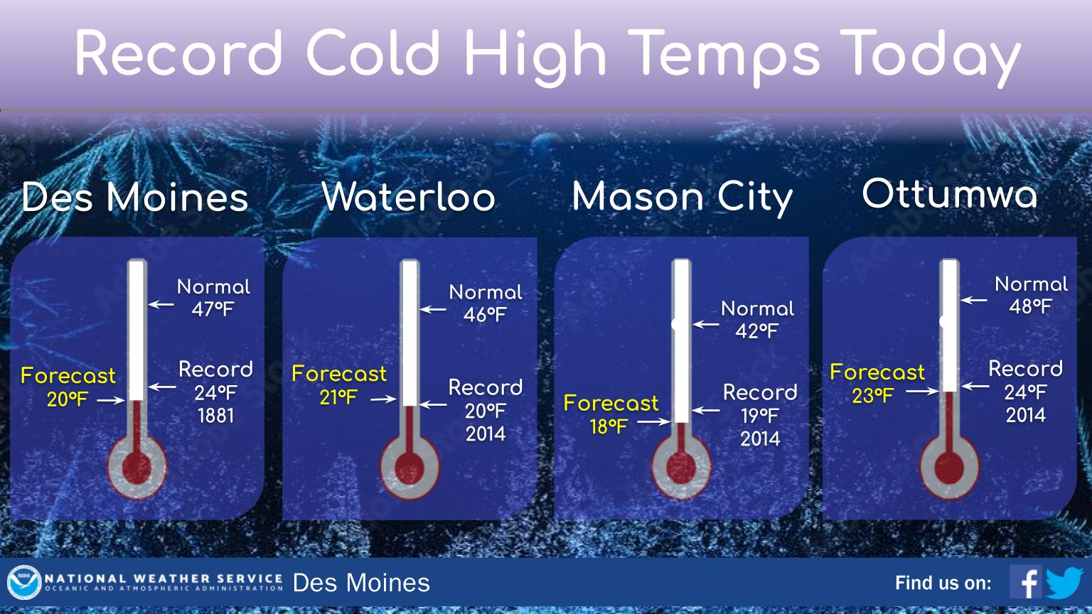
“We’re going to see a continuation of a few flurries and light snow showers as well over the next couple days, but as we get to Sunday and into early next week, we are looking at a warming trend,” Fowle says. “We’re not talking about beach weather or anything like that, but temperatures should be warming back up at least into the 30s and 40s, a little bit closer to the average highs for this time of year.” The extended forecast for next week shows little-to-no snow and highs in the 30s and 40s through Thanksgiving.


