
Today: Partly cloudy, with a high near 45. Winds S @ 15-30 mph.
Tonight: P/Cloudy, with a low around 32. S @ 5-10.
Tomorrow: P/Cldy to Cloudy. High around 45. S-NW @ 10-15.
Friday: Mostly cloudy. High near 40.
Saturday: Mostly cloudy. High 38.
Tuesday’s High in Atlantic, was 35 (the 24-hour high at 7-a.m. today). Our Low was 17. Last year on this date, the High temperature in Atlantic was 46 and the Low, 7. The Record High was 65 in 1984, and the Record Low was -25, in 1924.
Today: Partly cloudy & windy. High 32. S @ 15-25 mph.
Tonight: P/Cldy. Low 25. S @ 10.
Tomorrow: P/Cldy. High 47. S/SW @ 15-25.
Thursday: Mostly cloudy. High 47.
Friday: Mo. Cldy. High 42.
Monday’s High in Atlantic was 15. Our Low was -5. Last year on this date the High in Atlantic was 35 and the Low was 21. The Record High on this date was 65 in 1946. The Record Low was -21 in 1924.
(Radio Iowa) – Studies find nearly 75% of crashes in Iowa happen in less than two inches of snow, and researchers at the University of Iowa are looking into the ideal commute times. Professor Jon Davis, in the UI Department of Occupational and Environmental Health, says the timing of your drive can make a world of difference. “The commute is something that we often don’t think about as part of the actual workday in regards to health and safety,” Davis says, “but it really is, for a lot of people, the most dangerous thing they do all day.” 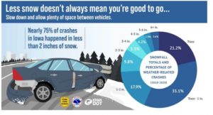
More people on the roads means more opportunities for a collision, and when the roads are slick from rain or snow, the risks of a fender-bender rise exponentially — especially during the busy morning commutes.

Jon Davis (UI photo)
“In our work, we actually looked at the different commute times and where we saw winter weather really playing a role in crashes began around 6:30 and didn’t start to taper off until 9,” Davis says. “So, if you can wait longer or avoid it all together, you are going to improve the safeness of your drive.”
During the height of the pandemic lockdown, 40% of Iowans were working remotely, and that number is still 25-to-30%. When the weather’s foul, Davis suggests if you can work from home, do, or at least go in later.
“If you delay your commute into work, you’re really increasing your safe drive,” Davis says. “It’s a lot less hazardous. Even waiting 30 minutes or an hour to go into work — and for those who can work remotely, you can completely remove that risk. It only takes a small amount of snow to make that drive more hazardous.”
The UI research found workplaces that adopt policies for flexible work start times or for telecommuting will empower workers to avoid hazardous driving conditions. “We put time and resources into making work-from-home easy. People have set up home offices, learned how to use different software to do virtual meetings, so let’s make use of that infrastructure,” Davis says. “For those people who have that option, it’s great if they can exercise that option when weather is bad.”
If you have to be at work in person and the weather’s foul, remember to dress for the conditions, bring along blankets, snacks, water, have a fully-charged cell phone and a full tank of gas.
Today: P/Cldy. High 15. N @ 15-25.
Tonight: Partly cloudy, with a low around 0. NW-SE @ 5-10.
Tomorrow: P/Cldy. High 33. S @ 15-25.
Wednesday: P/Cldy. High 47.
Thursday: Mostly Cloudy. High near 40.
Sunday’s High in Atlantic was 28. Our Low was -9. Snowfall in Atlantic was 1/2 inch (.05 melted value). Last year on this date the High in Atlantic was 44 and the Low was 20. The Record High on this date was 59 in 1936. The Record Low was -18 in 1892.
Today (Christmas Day): Snow, mainly after 3pm. High near 20. Wind chill values as low as -15. West northwest wind 5 to 14 mph becoming south in the afternoon. Winds could gust as high as 18 mph. Chance of precipitation is 80%. New snow accumulation of less than a half inch possible. **WIND CHILL ADVISORY UNTIL 10 A.M.**
Tonight: A chance of snow and freezing rain before 11pm, then a chance of freezing rain between 11pm and midnight, then a chance of snow after midnight. Cloudy, with a low around 9. Wind chill values as low as zero. Blustery, with a south southwest wind 9 to 18 mph becoming north northwest after midnight. Winds could gust as high as 26 mph. Chance of precipitation is 50%. New snow accumulation of less than a half inch possible.
Tomorrow: Mostly cloudy, then gradually becoming sunny, with a temperature falling to around 8 by 5pm. Wind chill values as low as -5. Blustery, with a north northwest wind 13 to 18 mph decreasing to 7 to 12 mph in the afternoon. Winds could gust as high as 25 mph.
Monday Night: Partly cloudy, with a low around -4. Light and variable wind becoming south 6 to 11 mph after midnight. Winds could gust as high as 18 mph.
Tuesday: Mostly sunny, with a high near 32. Breezy, with a south wind 13 to 18 mph, with gusts as high as 28 mph. Tue. Night: Partly cloudy, with a low around 26. Breezy.
Wednesday: Partly sunny, with a high near 39.
Saturday’s High in Atlantic was 10. Our Low this morning, -8. This day last year the high was 50 and the low was 16. The all-time record high was 60 in 2019. The record low of -20 was set in 1983. Sunrise this morning is 7:44 a.m. and sunset tonight is 4:55 p.m.
Skyscan Forecast Saturday, December 24, 2022 Austin Romer
Today: Mostly sunny. NW @ 20. High 10.
Christmas Eve: Mostly clear. NW @ 10. Low -6.
Christmas Day: Clouds increasing with a slight chance of developing snow. S @ 15. High 18.
Monday: Mostly cloudy. NW @ 20. High 15.
Tuesday: Mostly cloudy. S @ 20. High 35.
Yesterday’s high was 0 and the low was -11. This day last year the high was 52 and the low was 22. The all-time record high was 55 in 1893 and in 1964. The record low of -23 was set in 1983. Sunrise this morning is 7:44 a.m. and sunset tonight is 4:54 p.m.
Today: Patchy blowing snow. Partly cloudy and cold, with a high near -2. NW @ 20-35 mph.Wind chill values as low as -40. WIND CHILL WARNING IN EFFECT UNTIL NOON CST SATURDAY.…..WINTER WEATHER ADVISORY IN EFFECT UNTIL 6 AM CST SATURDAY. (Updated 4:45-a.m.)
Tonight: Partly cloudy, with a low around -9. NW @ 15-25. Wind chill values as low as -35.
Tomorrow (Saturday): P/Cldy. High 8. NW @ 15-25. Wind chill values as low as -30.
Christmas Day: P/Cldy. High around 22.
Monday: Cloudy w/a chance of light snow or mixed precip., High near 25.
Thursday’s High in Atlantic was -10. Our Low was -14. Last year on this date the High in Atlantic was 47 and the Low was 34. The Record High on this date was 62 in 1964. The Record Low was -22 in 1983.
(Radio Iowa) – There were brutally cold temperatures overnight in Iowa. Blizzard and Winter Storm Warnings from the National Weather will expire at 6 a.m. Saturday. Travel conditions remain difficult, if not impossible in much of Iowa as strong winds cause whiteout conditions. Craig Bargfrede, the Iowa D-O-T’s winter operations administrator, says more than a third of Iowa counties have issued towing bans.
“So if folks are out traveling right now and they do get stranded…we may be able to get emergency help out to them, but as far as getting their vehicle out of the ditch or wherever it’s stuck, that’s probably not going to happen,” Bargfrede says. In addition to blowing snow, icy conditions are causing wrecks. Bargfrede says it’s too cold to treat the roads with salt.
“We’re just basically resorting now to using a sand-salt mixture just to get some material out there and provide some friction, traction to the vehicles as they’re traveling,” Bargfrede says. Bargfrede says it will be a few more days before temperatures warm up enough for salt to be effective in treating ice. Crews at Iowa airports have been de-icing planes, but cancellations and significant delays in departure times were common.
Today: **WINTER STORM WARNING until 6-AM Saturday** A 30 percent chance of snow, mainly before 7am. Patchy blowing snow. Mostly cloudy and cold, with a temperature falling to around -12 by 9am. Wind chill values as low as -40. Windy, with a northwest wind 22 to 25 mph, with gusts as high as 38 mph. Little or no snow accumulation expected.
Tonight: Areas of blowing snow. Mostly cloudy, with a low around -13. Wind chill values as low as -40. Windy, with a northwest wind 24 to 26 mph, with gusts as high as 43 mph.
Friday: Areas of blowing snow. Mostly sunny and cold, with a high near -2. Wind chill values as low as -40. Windy, with a west northwest wind 25 to 28 mph, with gusts as high as 41 mph.
Friday Night: Patchy blowing snow. Partly cloudy, with a low around -11. Windy, with a northwest wind 20 to 25 mph, with gusts as high as 39 mph.
Saturday: Patchy blowing snow before 7am. Sunny and cold, with a high near 4. Blustery.
Christmas Day: Mostly sunny, with a high near 16.
Wednesday’s High in Atlantic was 21. Our Low this morning (As of 5:55-a.m) was-9. Snowfall from 7-a.m. Wed. thru 5:55-a.m. today, at KJAN, was .7″ (Seven-tenths of an inch). Last year on this date the High in Atlantic was 47 and the Low was 18. The Record High on this date was 65 in 1933. The Record Low was -27 in 1989. (We will have a total snowfall report at 7-a.m.)


