
Skyscan Forecast Saturday, February 18, 2023 Austin Romer
Today: Mostly cloudy. S @ 15. High 38.
Tonight: Partly cloudy. S @ 15. Low 27.
Sunday: Mostly sunny. SW @ 10. High 39.
Sunday Night: Partly cloudy. NW @ 5-10. Low 19.
Monday: Partly cloudy. SW @ 10. High 45.
Tuesday: Mostly cloudy. E @ 15. High 40.
Yesterday’s high was 32 and the low was -9. This day last year the high was 61 and the low was 6. The all-time record high was 67 set in 2017. The record low was -25 set in 1978. Sunrise is 7:12 a.m. and sunset tonight is 5:56 p.m.
Today: Areas of fog; Mostly sunny. High 30. SW @ 10 mph.
Tonight: P/Cldy. Low around 15. SW @ 5-10.
Tomorrow: P/Cldy. High 37. SW @ 10-20.
Sunday: P/Cldy. High 39.
Monday (Washington’s B-day): Mo. Cldy. High 39.
Thursday’s High in Atlantic was 23. Our Low this morning, -9. We received 4.3″ of snow after 7-a.m. Thursday (thru 1-p.m) at KJAN, for a total of 5.5-inches (1.2″ fell prior to 7-a.m. Wed.). Last year on this date the High in Atlantic was 30 and the Low was 7. The Record High on this date was 71 in 2017. The Record Low was -34 in 1958.
Early this morning: Snow. Patchy blowing snow after 5am. Steady temperature around 19. Wind chill values as low as 5. Blustery, with a north northeast wind around 16 mph, with gusts as high as 25 mph. Chance of precipitation is 80%. Total nighttime snow accumulation of 1 to 2 inches possible.
Today: **Winter storm warning until 6-p.m.** Snow, mainly before noon. High near 26. Wind chill values as low as 5. Blustery, with a north wind 14 to 17 mph, with gusts as high as 29 mph. Chance of precipitation is 90%. New snow accumulation of 1 to 3 inches possible.
Tonight: Mostly clear, with a low around 7. North northwest wind 6 to 11 mph becoming light after midnight. Winds could gust as high as 20 mph.
Friday: Sunny, with a high near 32. Wind chill values as low as zero. Light and variable wind becoming south southwest 9 to 14 mph in the morning. Winds could gust as high as 21 mph.
Saturday: Mostly sunny, with a high near 40.
Sunday: Mostly sunny, with a high near 43.
Wednesday High in Atlantic was 30. The Low was 18. We received 1″ of snow overnight at KJAN (as of 5:55-a.m. today). Last year on this date the High in Atlantic was 46 and the Low was 14. The Record High on this date was 64 in 2017. The Record Low was -33 in 1958.
Today: Cloudy, with a temperature falling to around 27 by 10am. Windy, with a west northwest wind 13 to 23 mph, with gusts as high as 34 mph.
Tonight: **WINTER STORM WARNING in effect at 9-p.m.**Snow, mainly after 10pm. The snow could be heavy at times. Areas of blowing snow after 1am. Low around 15. Wind chill values as low as zero. Blustery, with a north northeast wind 14 to 18 mph, with gusts as high as 29 mph. Chance of precipitation is 80%. New snow accumulation of 2 to 4 inches possible.
Thursday: **Winter Storm Warning continues until 6-p.m.**Snow likely, mainly before 10am. The snow could be heavy at times. Areas of blowing snow before 9am. Cloudy, then gradually becoming mostly sunny, with a high near 27. Wind chill values as low as zero. Blustery, with a north wind 14 to 18 mph, with gusts as high as 28 mph. Chance of precipitation is 70%. New snow accumulation of 1 to 3 inches possible.
Friday: Sunny, with a high near 31. Breezy, with a south southwest wind 5 to 10 mph increasing to 11 to 16 mph in the afternoon. Winds could gust as high as 23 mph.
Saturday: Sunny, with a high near 39. Breezy.
Tuesday’s High in Atlantic was 47. We received 1.13 inches of rain at the KJAN Studios. Our Low was 27. Last year on this date the High in Atlantic was 64 and the Low was 23. The Record High on this date was 72 in 1921. The Record Low was -31 in 1905.
Today: Cloudy w/rain & isolated thunderstorms. High around 50. S @ 15-25. New rainfall amounts between a half and three quarters of an inch possible.
Tonight: Rain ending. Mostly cloudy. Low around 30. W/NW @ 15-25.
Tomorrow: Mo. Cloudy. High 35. NW @ 10-20.
Thursday: Cloudy w/snow, mainly in the morning. High 28. New snow accumulations of 2 to 4 inches are possible.
Friday: P/Cloudy. High 28.
Monday’s High in Atlantic was 56. The Low was 21. Last year on this date the High in Atlantic was 42 and the Low was 11. The Record High on this date was 68 in 1934. The Record Low was -20 in 1936.
Experts expect a reduced flood risk across the Missouri River basin this spring, as much of the region is in drought. The U-S Army Corps of Engineers predicts runoff to be below average for a third straight year. John Remus, chief of the Corps’ Missouri River Basin Water Management Division, says they plan to continue water conservation measures this year, including releasing the minimum amount of water from upriver reservoirs. Remus says, “There is presently and will be adequate water in the reservoirs and in the river reaches between the reservoir systems and below the system to serve all our water supply needs.”
Remus says the Corps continues to monitor weather forecasts and river conditions and will make adjustments to releases, if needed. Kevin Low, a hydrologist with the Missouri River Basin Forecast Center, expects some springtime flooding for the lower basin because of thunderstorms. “We are projecting a lower-than-normal flood risk across the basin this spring,” Low says, “but even with this lowered flood risk, we do expect some flooding.”
The U.S. Army Corps of Engineers says soil moisture is drier-than-normal in much of the basin. The mountain snowpack and plains snowpack are near average and slightly above average.
(Katie Peikes, Iowa Public Radio)
Today: Partly cloudy. High 58. SW @ 10-20.
Tonight: Increasing clouds w/showers late. Low 38. S @ 10-15.
Tomorrow: Cloudy w/showers & isolated thunderstorms. High 49. S @ 15-25.
Wednesday: Mo. Cloudy. High 35.
Thursday: Cloudy w/snow. High near 30.
Sunday’s High in Atlantic was 49. Our Low this morning, 22. Last year on this date the High in Atlantic was 27 and the Low was 9. The Record High on this date was 63 in 1934. The Record Low was -30 in 1905.
Today: Partly sunny, with a high near 48. South southwest wind 6 to 10 mph becoming north northwest in the afternoon.
Tonight: Mostly cloudy, then gradually becoming mostly clear, with a low around 25. North northwest wind 5 to 7 mph becoming west after midnight.
Monday: Sunny, with a high near 53. South southwest wind 5 to 13 mph, with gusts as high as 18 mph.
Monday Night: A 20 percent chance of rain after midnight. Increasing clouds, with a low around 35. Breezy, with a south wind 10 to 18 mph, with gusts as high as 28 mph.
Tuesday: Rain. High near 48. Breezy, with a south southeast wind 17 to 20 mph, with gusts as high as 30 mph. Chance of precipitation is 100%. New precipitation amounts between a half and three quarters of an inch possible.
Tuesday Night: A 40 percent chance of rain before midnight. Mostly cloudy, with a low around 31. Windy. New precipitation amounts of less than a tenth of an inch possible.
Wednesday: Mostly cloudy, with a high near 39. Windy.
Saturday’s High in Atlantic was 47. Our Low was 25. Last year on this date, the High in Atlantic was 29 and the Low was -3. The Record High on Feb. 12th in Atlantic was 72 set back in 1990. The Record Low was -24, in 1986 & 1988.
(Radio Iowa) – The National Weather Service’s first look at the potential for flooding this spring shows most of the state in good shape. Hydrologist Jeff Zogg says eastern Iowa is the only area raising concern. “The first flood outlook for the state of Iowa for this spring is showing a near to below-normal risk of flooding. And most streams in the state the main exceptions, the Mississippi River in far eastern Iowa, where the risk is above normal,” Zogg says.
The snowpack in eastern Iowa is one part of the equation that raises the risk for the Mississippi River for flooding. “We consider a bunch of different factors when we assess the spring flood risk. We look at river levels, soil moisture, the snowpack, specifically, the liquid content, how much water is in that snowpack, frost depth, and we also consider the temperature and precipitation outlooks,” he says. Zogg says this year’s outlook is typical of the recent pattern.
“For the past couple of years, the spring flood outlooks have been pretty favorable for the state, not really any high risk of spring flooding across the state,” Zogg says. “Some locations, maybe a little bit above normal. Kind of like this year, the Mississippi is above normal risk, not much above normal, but above normal.” The second flood outlook will be released on February 23rd and Zogg says the updates take into account the forecast ahead. “The big thing that we have to look at is the future precipitation, things like rainfall or snowfall,” he says. “Of course, much of the face on a drought, so we would welcome the rainfall, it’s just that we don’t want it all at once. We want that rainfall spread out over time.” 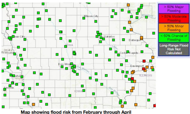
These flood outlooks are for the long-term potential for river flooding. “They really don’t consider things like flash flooding, it’s more of a shorter-term hazard. That’s usually in response to a localized heavy rainfall event,” Zogg says. “So, people still need to be aware of the potential for that if we have any heavy rainfall events going forward. And as people who live in Iowa for a while now, we can definitely get heavy rainfall events in the spring and summer.”
The third and final spring flood outlook will be released on March 9th.
Today: Sunny. High 48. NW winds at 10-15 mph.
Tonight: Mostly clear. Low around 27. S @ 15 mph.
Tomorrow: Cloudy. High 47. SW winds @ 5-10.
Monday: Mostly sunny. High 53.
Tuesday: Cloudy with a 95% chance of rain. High 49. SW @ 10-20 mph.
Friday’s High in Atlantic was 39. The Low was 13. Last year on this date the High in Atlantic was 49 and the Low was 4. The Record High on this date was 64 in 1951 & 1999. The Record Low was -26 in 1899.


