
Today: Cloudy w/patchy fog; A chance of drizzle, mainly after 2-p.m.. High near 42. SE winds around 5 mph.
Tonight: Cloudy w/patchy fog & a chance of drizzle or rain. A nearly steady temperature of around 40.
Friday: A 50% chance of rain. High near 47. Winds S @ 5-10 mph.
Fri. Night: Patchy fog; A 30% chance of rain, mainly before midnight. Low around 32.
Saturday: Partly sunny, with a high near 49.
Sunday: Mostly sunny, with a high near 50.
Monday: A 50% chance of rain after noon. Mostly cloudy, with a high near 46.
Wednesday’s High in Atlantic was 37. The Low was 31. Last year on this day (12/26), the High in Atlantic was 33 & the Low was 28. The Record High on this date was 59 in 1936, & the Record Low was -18, in 1892. Sunrise: 7:45; Sunset: 4:56.
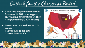
(Radio Iowa) – There wasn’t enough snowfall to give Iowa a white Christmas this year. National Weather Service meteorologist Brooke Hagenhoff says another color better describes the day. “Certainly going to be a bit of a gray Christmas. Pretty damp and dreary there in the afternoon, for sure,” she says. Hagenhoff says there will be some unseasonably warm weather the rest of the week.”We’re looking at temperatures in the upper 30s to pushing 40 degrees. We’re certainly going to warm up after Christmas. As we get into the upcoming weekend, we could see temperatures pushing 50 degrees or warmer,” Hagenhoff says. Snow isn’t in the long-term picture, but there will be some precipitation.
“We do have a system that will come up on Thursday into Friday, that will bring chances for rain state area, and perhaps another chance there on Saturday as well,” She says. “Thankfully, with the warmer temperatures we’re looking at, that being in the liquid form, which should make travel a little easier for anyone returning back to the area from holiday travels.” The New Year may start out colder. “As we get into kind of parts of next week, temperatures may come down just a little bit. We’re looking at temperatures returning likely to the mid 30s, closer to normal, as we get towards New Year’s ,” she says.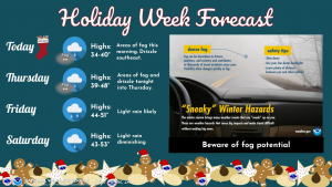
Hagenhoff says they’ll fine tune the forecast toward the end of the week to get a better idea of what we can expect to start the New Year.
Christmas Day: Patchy fog through about 1-pm, otherwise cloudy, with a high near 38. Southeast winds 5 to 10 mph.
Tonight: Cloudy w/patchy fog, and a slight chance of drizzle. Low around 33.
Tomorrow: Cloudy w/patchy morning fog, & a chance of drizzle in the afternoon. High near 45. E/SE @ 5-10.
Tom. Night: Cloudy w/a 40% chance of rain. Low around 40. New precipitation amounts of less than a tenth of an inch possible.
Friday: A 50% chance of rain. High near 49. New precipitation amounts of less than a tenth of an inch possible.
Friday Night: A 50% chance of rain. Low around 34.
Saturday: Partly sunny, with a high near 50.
Saturday Night: Mostly cloudy, with a low around 30.
Sunday: Mostly sunny, with a high near 49.
Tuesday’s High in Atlantic was 34. The Low was 30. Last year on this day (12/25), the High in Atlantic was 36 & the Low was 28. The Record High on this date was 60 in 2019, & the Record Low was -20, in 1983. Sunrise: 7:44; Sunset: 4:55.
Today: Cloudy, with a high near 37. Northeast wind around 5 mph.
Tonight: Cloudy w/patchy fog after midnight. Low around 26.
Christmas Day: Patchy fog in the morning, otherwise, cloudy, with a high near 39. Southeast wind 5 to 10 mph.
Wednesday Night: Patchy fog after 11pm. Otherwise, cloudy, with a low around 33. E/SE @ 5 mph.
Thursday: Cloudy w/areas of fog in the morning & patchy drizzle in the afternoon. A high near 45.
Thu. Night: Areas of drizzle before midnight, then a chance of rain after midnight. Low around 40.
Friday: A 50% chance of rain. High near 50.
Friday Night: A 40% chance of rain. Low around 38.
Saturday: Mostly cloudy, with a high near 50.
Monday’s High in Atlantic was 46. The Low was 26. Last year on this day (12/24), the High in Atlantic was 57 & the Low was 33. The Record High on this date was 57 in 2023, & the Record Low was -23, in 1983. Sunrise: 7:44; Sunset: 4:54.
Today: Partly sunny, with a high near 44. Northwest wind 5 to 10 mph.
Tonight: Partly cloudy, w/patchy fog after midnight. Low around 22.
Tomorrow: Areas of fog thru mid-morning, otherwise partly sunny. High near 38. E/SE winds at around 5 mph.
Christmas Eve (Tuesday Night): Mostly cloudy, with a low around 23.
Christmas Day: Partly sunny, with a high near 41.
Wednesday Night: Cloudy, with a low around 29.
Thursday: A slight chance of rain in the afternoon. High near 47.
Friday: A 50% chance of rain. High near 49.
Sunday’s High in Atlantic was 49. The Low was 26. Last year on this day (12/23), the High in Atlantic was 55 & the Low was 34. The Record High on this date was 62 in 1964, & the Record Low was -22, in 1983. Sunrise: 7:43; Sunset: 4:53.
Today: Mostly sunny & breezy. A high near 46. South winds @ 10 to 20 mph, with gusts as high as 30 mph.
Tonight: Mostly cloudy, with a low around 29. South winds @ 5 to 15 mph becoming west after midnight w/gusts as high as 20 mph.
Monday: Mostly cloudy to start off, then gradually becoming sunny. A high near 42. W/NW winds 5 to 10 mph.
Monday Night: Mostly cloudy, with a low around 22.
Tuesday: Partly sunny, with a high near 41. Winds E/SE @ around 5 mph.
Tuesday Night: Mostly cloudy, with a low around 25.
Christmas Day: Partly sunny, with a high near 44.
Wed. Night: A 20% chance of rain after midnight. Low around 30.
Thursday: A 30% chance of rain. High near 46.
Saturday’s High in Atlantic was 32. The Low was 18. Last year on this day (12/22), the High in Atlantic was 51 & the Low was 34. The Record High on this date was 65 in 1933, & the Record Low was -27, in 1989. Sunrise: 7:42; Sunset: 4:52.
Today: Mostly sunny. High near 33. S winds 5-10. Wind chill values as low as 10.
Tonight: Mostly clear. Low around 21. South wind 5 to 10 mph.
Tomorrow: Mostly sunny & breezy. High near 45. S winds 10-20 w/gusts to around 30 mph.
Tom. Night: Mostly cloudy, with a low around 27.
Monday: Mostly sunny, with a high near 44.
Tuesday: Partly sunny, with a high near 41.
Tue. Night (Christmas Eve): Mostly cloudy, with a low around 24.
Christmas Day: Partly sunny, with a high near 41.
Friday’s High in Atlantic was 28. Our Low this morning was 9. Last year on this day (12/21), the High in Atlantic was 55 & the Low was 42. The Record High on this date was 58 in 1941, & the Record Low was -22, in 1989. Sunrise: 7:42; Sunset: 4:52.
Today: Partly sunny, with a high near 26. N/NW winds 15-30 mph this morning becoming light N/NE this afternoon. Wind chill values as low as -5.
Tonight: Mostly cloudy, with a low around 15. Light and variable wind.
Tomorrow: Sunny, with a high near 34. Light southeast wind becoming south 5 to 10 mph in the morning.
Tom. Night: Mostly clear, with a low around 21. South wind 5 to 10 mph.
Sunday: Mostly sunny & breezy, with a high near 45.
Sunday Night: Mostly cloudy, with a low around 29.
Monday: Mostly sunny, with a high near 47.
Tuesday: Partly sunny, with a high near 42.
Thursday’s High in Atlantic was 53. Our Low was 12. Last year on this day (12/20), the High in Atlantic was 49 & the Low was 21. The Record High on this date was 61 in 1941, & the Record Low was -25, in 1901. Sunrise: 7:42; Sunset: 4:52.
Today: Mostly sunny & windy. High near 48. **WIND ADVISORY FROM 11-A.M. UNTIL 8-P.M.** S/SW winds 15-30 mph w/gusts to near 40 mph.
Tonight: Partly cloudy, with a low around 12. NW winds 15-35 w/gusts to near 40. Wind chill values as low as -5.
Tomorrow: Mostly sunny & blustery. High near 26. N/NW winds 10-25 mph becoming NE during the afternoon., Wind chill values as low as zero.
Tom. Night: Mostly cloudy, with a low around 14. Light and variable wind.
Saturday: Sunny, with a high near 33.
Sunday: Mostly sunny, with a high near 41.
Monday: Mostly sunny, with a high near 44.
Wednesday’s High in Atlantic was 33. Our Low was 18. Last year on this day (12/19), the High in Atlantic was 48 & the Low was 21. The Record High on this date was 58 in 1966, & the Record Low was -33, in 1983. Sunrise: 7:41; Sunset: 4:51.
(Radio Iowa) – Iowans who are dreaming of a white Christmas, may have to head further north. National Weather Service meteorologist Brooke Hagenhoff says the long-range forecast now reaches December 25th, and it does -not- appear there will be any measurable snowfall on the ground during the middle of next week. “We’re looking at chances for above-normal temperatures,” Hagenhoff says, “so while we can’t completely rule out an outlier event with some snow in there, it certainly looks unlikely that we’ll have a white Christmas this year.” While school kids and anyone with nostalgic memories of snowy holidays may be disappointed, the news is likely welcome for anyone who will have make a long drive, but Hagenhoff says there’s still a chance of snow, though it’s slim.
“At this point, it’s hard to pin down what exactly the temperatures will look like, but this time of year, average temperatures are in the mid to upper 30s across the area,” Hagenhoff says. “So if we’re looking at above-normal temperatures, we could certainly see temperatures in the 40s or maybe close to 50, depending on how the pattern plays out as it gets a little closer.”
NWS graphic
Scattered snow is in the forecast for tomorrow (Thursday), but little accumulation is expected, and whatever snow does fall is likely to melt before the 25th, if temperatures warm.


