
(Western Iowa) – Crews in western and southwest Iowa kept busy Thursday afternoon, battling the wind and flames that spurred two separate large field fires. The fires occurred within a couple of hours of one another. One of the incidents involved a soybean field in northwestern Audubon County. Firefighters from Manning, Manilla, Irwin, Defiance, Kirkman, and Audubon responded to the scene. Shelby County Emergency Management noted on their social media page, that “It was fast moving,” and that crews “did a GREAT job stopping it from getting to the next field of standing corn!!!!”
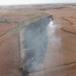
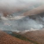
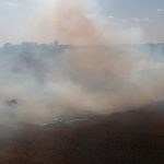
Click on the images to enlarge

Photos via Shelby County EMA Facebook page
Henderson, Emerson, Hastings, Stanton firefighters were paged out Thursday, to the area of Highway 34 and A Avenue in Montgomery County, where a large corn field fire was occurring. Some equipment was burning in that incident as well. Crews battled the flames for at least three hours before they were brought under control.
No injuries were reported from either incident.
(Des Moines, Iowa) – The latest U-S Drought Monitor report shows conditions worsening across Iowa. The report, issued Thursday, said 100% of Iowa is experiencing abnormally dry conditions, marking the first time since August 2013 that all of the state has had some sort of drought designation. 57% of Iowa is experiencing moderate drought, an increase from 52% just a week ago, while 27% of Iowa is dealing with severe drought. 7% of Iowa has extreme drought. Plymouth, Cherokee, Buena Vista and Pocahontas Counties, along with parts of seven other counties in northwest Iowa, are included in the Extreme Drought conditions.
Cass and Adair Counties are in a moderate drought, as is much of Madison County and most of Pottawattamie County. Half of the counties to our south are Moderately or Abnormally Dry. Most of the counties adjacent to Cass and to the north of I-80 are also Abnormally Dry. There were two separate, large field fires Thursday afternoon in southwest/western Iowa.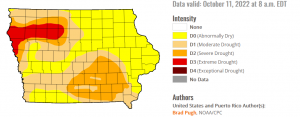
As was the case in August 2022, much of the Des Moines metro is experiencing moderate drought, while cities like Albia, Centerville, Chariton, Grinnell, Indianola, Newton, Osceola, Oskaloosa and Ottumwa are dealing with severe drought.
Ongoing drought, low relative humidity, and strong winds are contributing to heightened fire danger across the state. The long-term weather pattern does not favor any sort of drought-busting weather, as there are only limited rain chances in the extended forecast. Meaningful rainfall would be beneficial before winter arrives, otherwise much of Iowa will enter spring planting season with significant drought concerns.
New reports are issued by the U.S. Drought Monitor each Thursday. The updates account for any rain that has fallen through the Tuesday prior to each report’s release.
Today: Partly cloudy. High 62. W/NW winds @ 10-20 mph.
Tonight: P/Cldy. Low 30. NW @ 5-10.
Tomorrow: P/Cldy. High 64. W @ 10-15.
Sunday: P/Cldy. High near 60.
Monday: P/Cldy. High 55.
Thursday’s High in Atlantic was 56. Our Low was 30. Last year on this date the High in Atlantic was 66 and the Low was 40. The Record High on this date was 88 in 1897. The Record Low was 16 in 1937.
Today: **Red Flag Warning this afternoon**Partly cloudy. High 59. W/NW winds @ 15-30 mph+.
Tonight: Fair to P/Cldy. Low 32. NW @ 5-10.
Tomorrow: P/Cldy. High 62. W @ 10-20.
Saturday: P/Cldy. High 64.
Sunday: P/Cldy. High 62.
Wednesday’s High in Atlantic was 68. Our Low this morning, 43. Last year on this date the High in Atlantic was 71 and the Low was 42. The Record High on this date was 88 in 1975. The Record Low was 15 in 1907.
Harrison-Shelby-Pottawattamie-Mills-Fremont-Washington-Douglas-
Sarpy-Lancaster-Cass-Otoe-Saline-Jefferson-Gage-Johnson-Nemaha-
Pawnee-Richardson-
1033 AM CDT Wed Oct 12 2022

...RED FLAG WARNING IN EFFECT UNTIL 7 PM CDT THIS EVENING FOR
WIND AND LOW RELATIVE HUMIDITY FOR EASTERN NEBRASKA AND FAR
WESTERN IOWA...
...FIRE WEATHER WATCH REMAINS IN EFFECT FROM THURSDAY AFTERNOON
THROUGH THURSDAY EVENING FOR WIND AND LOW RELATIVE HUMIDITY FOR
EASTERN NEBRASKA AND FAR WESTERN IOWA...

The National Weather Service in Omaha/Valley has issued a Red
Flag Warning for wind and low relative humidity, which is in
effect until 7 PM CDT this evening.

* Affected Area...In Iowa, Harrison, Shelby, Pottawattamie,
  Mills and Fremont. In Nebraska, Washington, Douglas, Sarpy,
  Lancaster, Cass, Otoe, Saline, Jefferson, Gage, Johnson,
  Nemaha, Pawnee and Richardson.

* Winds...Northwest 15 to 25 mph with gusts up to 40 mph.

* Relative Humidity...As low as 21 percent.

* Impacts...Any fires that ignite may spread rapidly and exhibit
  extreme fire behavior. Use extreme caution if engaging in any
  activities that could start a fire. Outdoor burning is not
  advisable.

PRECAUTIONARY/PREPAREDNESS ACTIONS...

A Red Flag Warning means that critical fire weather conditions
are either occurring now, or will shortly. A combination of
strong winds, low relative humidity and warm temperatures can
contribute to extreme fire behavior.

A Fire Weather Watch means that critical fire weather conditions
are forecast to occur. Listen for later forecasts and possible
Red Flag Warnings.
Special Weather Statement from the National Weather Service Des Moines IA for the following area Counties: Sac-Crawford-Carroll-Audubon-Guthrie-Dallas-Cass-Adair-Madison-Adams-Union-Taylor-Ringgold
…Gusty Winds and Elevated Fire Danger Today and Tomorrow…
Northwest winds are expected to increase into the afternoon both today and tomorrow with gusts reaching 30 to 40 mph, and possibly higher at times. These winds will also be coincident with lower relative humidities resulting in elevated fire weather conditions where fires may develop and spread quickly.
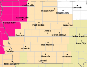
Red Flag Warning (counties in pink); Fire Weather Watch (tan); Special Wx Statement (light brown/flesh color).
Open burning is discouraged and farmers are urged to be cautious during harvest activities. Gusty winds may blow around unsecured objects, such as Halloween decorations.
Harrison-Shelby-Pottawattamie-Mills-Fremont Counties ..
A FIRE WEATHER WATCH IS IN EFFECT FROM NOON TODAY THROUGH THIS EVENING FOR WIND AND LOW RELATIVE HUMIDITY FOR PORTIONS OF SOUTHEAST NEBRASKA AND WESTERN IOWA… …A FIRE WEATHER WATCH REMAINS IN EFFECT FROM THURSDAY AFTERNOON THROUGH THURSDAY EVENING FOR WIND AND LOW RELATIVE HUMIDITY FOR MOST OF EASTERN NEBRASKA AND SOUTHWEST IOWA. ( https://www.weather.gov/dmx/)
* Winds…Northwest 15 to 25 mph with gusts up to 40 mph.
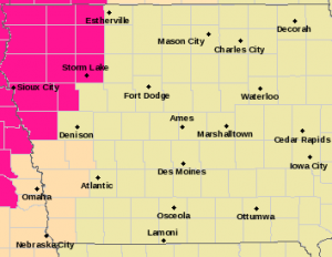
Fire Weather Watch (counties in flesh color); Red Flag Warning (Counties in pink).
* Relative Humidity…As low as 20 percent.
* Impacts…Any fires that ignite may spread rapidly and exhibit extreme fire behavior. Use extreme caution if engaging in any activities that could start a fire. Outdoor burning is not advisable.
PRECAUTIONARY/PREPAREDNESS ACTIONS… A Fire Weather Watch means that critical fire weather conditions are forecast to occur. Listen for later forecasts and possible Red Flag Warnings.
Today: Partly cloudy to cloudy. High 65. NW winds @ 15-30 mph+.
Tonight: P/Cldy. Low 37. NW @ 10-15+.
Tomorrow: P/Cldy. High 59. NW @ 10-15.
Friday: P/Cldy. High 64. Windy.
Saturday: P/Cldy. High 62.
Tuesday’s High in Atlantic was 80. Rainfall overnight amounted to .43″ (as of 5:30-a.m.). Our Low this morning (as of 5-a.m.) was 54. Last year on this date the High in Atlantic was 79 and the Low was 37. The Record High on this date was 90 in 1899. The Record Low was 17 in 1908.
Today: Partly cloudy. High near 80. SW winds @ 10-20 mph.
Tonight: Showers & some thunderstorms are possible. Low around 50. S-NW @ 10-15.
Tomorrow: P/Cldy & cooler. High 65. NW @ 10-20.
Thursday: P/Cldy. High 59. Windy.
Friday: P/Cldy. High 62.
Monday’s High in Atlantic was 80. Our Low was 32. Last year on this date the High in Atlantic was 71 and the Low was 37. The Record High on this date was 93 in 1893. The Record Low was 17 in 1987.


