
Today: Partly cloudy. High 78. S winds @ 10-15 mph.
Tonight: P/Cldy. Low 50. S @ 5-10.
Tomorrow: P/Cldy. High 80. SW @ 10-20 mph. Tues. Night: A chance of showers & thunderstorms. Low around 48.
Wednesday: P/Cldy. High 62.
Thursday: P/Cldy. High 59.
Sunday’s High in Atlantic was 77. Our Low was 29. Last year on this date the High in Atlantic was 68 and the Low was 54. The Record High on this date was 96 in 1895. The Record Low was 17 in 1906.
Today: Sunny, with a high near 74. Light southwest wind becoming west 8 to 13 mph in the morning. Winds could gust as high as 18 mph.
Tonight: Mostly clear, with a low around 41. Northwest wind around 5 mph becoming calm in the evening.
Columbus Day: Sunny, with a high near 78. Light south southeast wind becoming south 5 to 10 mph in the afternoon.
Monday Night: Mostly clear, with a low around 53. South wind 6 to 8 mph, with gusts as high as 18 mph.
Tuesday: A slight chance of showers between 1pm and 4pm, then a slight chance of showers and thunderstorms after 4pm. Mostly sunny, with a high near 78. Windy, with a south southwest wind 10 to 15 mph increasing to 16 to 21 mph in the afternoon. Winds could gust as high as 29 mph. Chance of precipitation is 20%.
Tuesday Night: A 50 percent chance of showers and thunderstorms. Partly cloudy, with a low around 49. New rainfall amounts between a tenth and quarter of an inch, except higher amounts possible in thunderstorms.
Wednesday: A slight chance of thunderstorms before 7am. Mostly sunny, with a high near 67. Breezy. Chance of precipitation is 10%.
Saturday’s High in Atlantic was 65. The Low was 22. Last year on this date, our High was 75 and the Low was 56. The Record High for this date, was 87 in 1930, 1938, & 2020. The Record Low was 14, in 2000.
A Freeze Warning continues for the entire State of Iowa until 9-a.m. Today (Saturday)
* WHAT…Sub-freezing temperatures, as low as the mid 20s north.
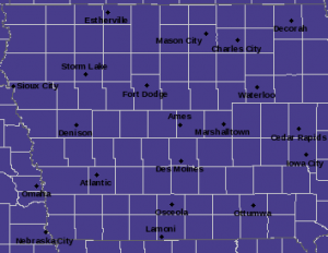
Freeze Warning for counties in purple, until 9-a.m. (10/8/22)
* WHEN…Until 9 AM CDT this morning.
* IMPACTS…Frost and freeze conditions will kill crops, other sensitive vegetation and possibly damage unprotected outdoor plumbing.
Today: **Freeze Warning until 9-a.m.** Areas of fog this morning, otherwise mostly sunny. High 63. SW Winds @ 10 mph.
Tonight: Mostly clear. Low 38. SW Winds @ 5-10.
Tomorrow: Mostly sunny. High 72. SW @ 10-15 mph.
Monday (Columbus Day): P/Cldy. High 74.
Tuesday: P/Cldy. High 76.
Friday’s High in Atlantic was 56. Our Low this morning was 22. Last year on this date the High in Atlantic was 84 and the Low was 51. The Record High on this date was 93 in 1893. The Record Low was 19 in 1908 & 2000.
Today: Partly Cloudy. High 56. N Winds @ 10 mph.
Tonight: Mostly clear. Low 25. Winds light & variable.
Tomorrow: Mostly sunny. High 63. SW @ 10 mph.
Sunday: P/Cldy. High 72.
Monday (Columbus Day): P/Cldy. High near 70.
Thursday’s High in Atlantic was 69. Our Low this morning was 39. Last year on this date the High in Atlantic was 76 and the Low was 51. The Record High on this date was 88 in 1938. The Record Low was 16 in 1952 & 2012.
The National Weather Service has issued a Freeze Warning for most Iowa, effective Saturday (Oct. 8th) from 1-am until 9-a.m.
* WHAT…Sub-freezing temperatures as low as 28 expected.
* IMPACTS…Frost and freeze conditions will kill sensitive vegetation and possibly damage unprotected outdoor plumbing.
PRECAUTIONARY/PREPAREDNESS ACTIONS…
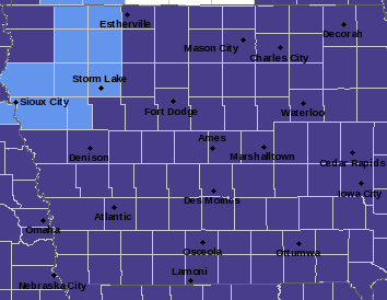
Freeze Warning for Counties in purple; Frost Advisory for Counties in light blue.
Take steps now to protect tender plants from the cold. To prevent freezing and possible bursting of outdoor water pipes they should be wrapped, drained, or allowed to drip slowly. Those that have in-ground sprinkler systems should drain them and cover above-ground pipes to protect them from freezing.
Today: Partly Cloudy. High 68. N Winds @ 15-25 mph.
Tonight: P/Cldy. Low 35. N @ 5-10.
Tomorrow: P/Cldy. High 56. N @ 10 mph.
Saturday: Mostly sunny. High 65.
Sunday: P/Cldy. High near 70.
Wednesday’s High in Atlantic was 75. Our Low this morning was 43. Last year on this date the High in Atlantic was 76 and the Low was 53. The Record High on this date was 91 in 1963 & 1997. The Record Low was 15 in 2012.
(Radio Iowa) – The La Nina weather system often brings Iowa and the Midwest an above-normal helping of precipitation, but even though the pattern is expected to stick around for yet another winter, we’re still suffering with drought. Doug Kluck, the climate services director for the Central Region of the National Weather Service, says there would normally be a lot more rainfall, especially in the Missouri River basin. Kluck says, “It is possible that La Nina can contribute in a positive manner more usable precipitation for the basin.” The expected amount of precip simply hasn’t been materializing, he says, and it’s unclear whether that will change with the snowpack in the winter season ahead.
“The last two years have been La Nina and those last two years have been something like 88 and 90% of normal snowpack, where we would hope that La Nina would give us over 100%,” Kluck says, “but that didn’t happen.” Kluck says this situation is what adds to so much climate prediction uncertainty. “It tells you the fickleness, to be honest, of using La Nina only as a forecast tool for that neck of the woods,” he says.
The National Climate Prediction Center is forecasting this La Nina will fade away by early spring. The latest report from the U-S Drought Monitor shows 80 percent of Iowa is either abnormally dry or in some level of drought.
Today: Light rain ending this morning; Partly Cloudy to Cloudy. High 74. Wind NW @ 10 mph.
Tonight: P/Cldy. Low 50. Wind light & variable.
Tomorrow: P/Cldy. High 68. N @ 10-20 mph.
Friday: P/Cldy. High 58.
Saturday: P/Cldy. High 66.
Tuesday’s High in Atlantic was 83. The Low was 50. We received light rain early this morning, amounting to slightly more than a Trace. Last year on this date, the High in Atlantic was 77 and the Low was 47. The Record High was 93 in 1963. The Record Low was 22 in 2012.
Today: Partly Cloudy. High near 80. Wind S @ 10-20 mph.
Tonight: P/Cldy to Cldy w/scattered showers late. Low 56. S @ 5-10 mph.
Tomorrow: A chance of showers in the morning; Becoming P/Cldy. High 75. NW @ 10 mph.
Thursday: P/Cldy. High 66.
Friday: /Cldy. High 58.
Monday’s High in Atlantic was 79. The Low was 43. Last year on this date, the High in Atlantic was 81 and the Low,43. The Record High was 90 in 1938 & 2005. The Record Low was 20 in 1968.


