
Today: Mostly Sunny. High 88. S @ 15 mph.
Tonight: Mostly cloudy. Low 66. S @ 15.
Tomorrow: Mostly cloudy. High 85. S 10-20.
Friday: Partly cloudy to cloudy w/a chance of rain late. High 85. S @ 15 mph.
Saturday: P/Cldy w/a chance of rain. High 93. S @ 10-20.
Tuesday’s High in Atlantic was 84. The Low was 44. Last year on this date the High in Atlantic was 79 and the Low was 47. The Record High on this date was 99 in 1939. The Record Low was 29 in 1892.
Today: Sunny. High 83. SE winds at 10 mph.
Tonight: Clear. Low 62. SE @ 10.
Tomorrow: Mostly Sunny. High 90. S 10-15.
Thursday: Mostly cloudy. High 88. S @ 15 mph.
Friday: Mo. Cloudy w/a chance of rain. High 90. S @ 10-20.
Monday’s High in Atlantic was 80. The Low was 42. Last year on this date the High in Atlantic was 87 and the Low was 61. The Record High on this date was 98 in 1893 & 1939. The Record Low was 25 in 1902.
Today: Sunny, with a high near 77. Light northwest wind increasing to 5 to 10 mph in the morning.
Tonight: Mostly clear, with a low around 48. North wind around 5 mph becoming calm in the evening.
Tomorrow: Sunny, with a high near 81. Calm wind becoming south 5 to 9 mph in the morning.
Wednesday: Sunny, with a high near 87.
Thursday: Mostly sunny, with a high near 86. Breezy.
Sunday’s High in Atlantic was 76. Our Low this morning, 42. Last year on this date the High in Atlantic was 76 and the Low was 62. The Record High on this date was 97 in 1939 & 2000. The Record Low was 28 in 1902.
Today: Sunny, with a high near 73. Light north northwest wind increasing to 8 to 13 mph in the morning. Winds could gust as high as 18 mph.
Tonight: Mostly clear, with a low around 44. Northwest wind 5 to 7 mph becoming calm in the evening.
Monday: Sunny, with a high near 75. Light northwest wind becoming north northwest 6 to 11 mph in the morning.
Monday Night: Clear, with a low around 48. Calm wind.
Tuesday: Sunny, with a high near 82. Calm wind becoming south 5 to 7 mph in the morning.
Tuesday Night: Mostly clear, with a low around 55.
Wednesday: Sunny, with a high near 84.
We received .53″ rain Saturday at the KJAN Studios. The High in Atlantic was 64. Our Low this morning was 44. Last year on this date the High in Atlantic was 91 and the Low was 56. The Record High on this date was 96 in 1895 & 1936. The Record Low was 31 in 1955.
Today: Mostly cloudy w/a 70% chance of rain. High 61. N @ 10-15.
Tonight: Cloudy w/a rain ending this evening; Becoming partly cloudy. Low 47. NE @ 10.
Tomorrow: Mostly sunny. High 74. N @ 10.
Monday: Sunny. High 76. W @ 10.
Tuesday: Mostly sunny. High 86. S @ 10-15.
Friday’s High in Atlantic was 86. Our Low this morning, 56. We received .06″ of rain early this morning at KJAN. Last year on this date the High in Atlantic was 86 and the Low was 55. The Record High on this date was 86 in 1938. The Record Low was 36 in 1959.
(Radio Iowa) – August saw below-normal rainfall — but drought conditions did improve in some parts of the state. The D-N-R’s Tim Hall says some areas didn’t get the rain from thunderstorms. “You sort of have to look at it regionally. And some parts of Southeast Iowa were accepted exceptionally dry in the month of August,” Hall says. August was the fifth straight month with below-normal precipitation, and Hall says the state needs a rainfall rally.”To get out of a drought that’s been sort of lingering and brewing for a couple of years, it’s going to take month over month over month of above normal rainfall,” he says.
“We haven’t seen but one month this year, where we’ve had above normal rainfall statewide. We haven’t seen the conditions that we’d like to see that’ll start to dig us out of this long-term condition.” Rivers and streams are running low in some of the drought areas — which can lead to more problems.”There’s water quality issues that come along with decreased streamflow and groundwater. There’s some communities battling nitrate issues. So in northwest Iowa, it’s not very good. And if you look at the streamflow in southeast Iowa, it is also trending downward,” according to Hall. 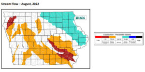
The fall months are not normally the wettest of the year in Iowa — but Hall says there is some positive recent history. “Going back to 2016 — a really wet September, 2017 a really wet October, 2018 a really wet September, 2019 a really wet September, and last year a really wet October. So we’ve seen the emergence of the trend I think that shows September and or October being above normal for precipitation,” Hall says. He says the timing of the rains are key to rebuilding subsoil moisture. “There is there’s ample opportunity to get some much needed rainfall going into the winter. Depends how much we get and how much gets locked into the soil moisture before the ground freezes,” Hall says.
The latest drought monitor showed just a slight increase in the percentage of the state that doesn’t have any type of drought.
Today: Sunny to partly sunny. High 85. SW @ 10-15.
Tonight: Cloudy w/a slight chance of rain. Low 58. N @ 10-15.
Tomorrow: Cloudy & cooler, w/a 40% chance of rain. High 68. N @ 10-15.
Sunday: A slight chance of rain in the morning; Becoming mostly sunny. High 76. N @ 10.
Monday: Mostly sunny. High 84. W @ 10-15.
Thursday’s High in Atlantic was 86. Our Low was 56. Last year on this date the High in Atlantic was 81 and the Low was 45. The Record High on this date was 100 in 1893. The Record Low was 36 in 1959.
Today: Areas of fog this morning; Mostly sunny. High 87. S @ 10-15.
Tonight: Mostly clear. Low 65. S @ 5-15.
Tomorrow: Mostly Sunny. High 89. SW @ 10-15.
Saturday: Cloudy w/a 65% chance of rain. High 67. NE @ 10-15.
Sunday: Cloudy w/a chance of rain (mainly in the a.m.); Becoming Mo. Sunny. High 76. N @ 10-15.
Wednesday’s High in Atlantic was 86. Our Low this morning, 54. Last year on this date the High in Atlantic was 81 and the Low was 45. The Record High on this date was 100 in 1947. The Record Low was 36 in 1986.
Today: Mostly sunny, with a high near 86. Calm wind becoming east around 5 mph in the afternoon.
Tonight: Partly cloudy, with a low around 60. Southeast wind around 5 mph becoming calm in the evening.
Tomorrow: Mostly sunny, with a high near 88. Breezy, with a south wind 5 to 10 mph increasing to 11 to 16 mph in the afternoon. Winds could gust as high as 22 mph.
Friday: Mostly sunny, with a high near 86.
Friday Night: A slight chance of showers, then a chance of showers and thunderstorms after 10pm. Mostly cloudy, with a low around 56. Chance of precipitation is 30%.
Saturday: A chance of showers and thunderstorms. Mostly cloudy, with a high near 73. Chance of precipitation is 40%.
Tuesday’s High in Atlantic was 83. Our Low this morning, 57. Last year on this date the High in Atlantic was 84 and the Low was 52. The Record High on this date was 98 in 1893. The Record Low was 34 in 1956.
Special Weather Statement – National Weather Service Des Moines IA
615 AM CDT Tue Sep 6 2022
The National Weather Service reports areas of fog have developed across much of Iowa overnight, and patchy dense fog is reducing visibility to below a quarter of a mile at times in some locations. Please allow extra travel time this morning and use caution while driving. The fog should steadily improve and dissipate after sunrise.
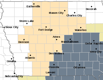
Special Weather Statement for counties in light brown; Dense Fog Advisory until 9-a.m. for counties in dark gray.
Area Counties affected include: Sac-Crawford-Carroll-Greene-Audubon-Guthrie-Dallas-Polk-Cass-Adair-Madison-Adams-Union-Taylor and Ringgold.


