
The Shelby County Emergency Management Agency reports the County FIRE DANGER index will continue in the “Moderate” category this weekend, due to the anticipated dry, sunny and windy conditions. Dry vegetation is creating the potential for controlled burns to spread out of control.
The next Local update will be Monday, March 6th.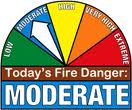
Today: Partly Cloudy to cloudy. High 46. SE @ 10-20.
Tonight: P/Cloudy. Low 26. S @ 5-10.
Tomorrow: Mostly sunny. High 65. SW @ 15-25.
Sunday: P/Cldy. High near 70.
Monday: Mo. Cldy w/a chance of showers. High around 65.
Thursday’s High in Atlantic was 42. Our Low this morning (as of 5:30-a.m.) was 16. Last year on this date, our High in Atlantic was 42 and the low was 26. The Record High in Atlantic on this date was 79 in 1983. The Record Low was -11 in 2014.
Today: Partly Cloudy. High 40. S winds becoming northerly @ 10-15.
Tonight: P/Cloudy. Low 18.
Tomorrow: P/Cldy to Cldy. High 46. SE @ 10-20.
Saturday: P/Cldy. High 65.
Sunday: P/Cldy. High near 70.
Wednesday’s High in Atlantic was 41. Our Low this morning was 19. We received a Trace of precipitation in Atlantic Wednesday, in the form of mid-morning snow showers or flurries that quickly melted. Last year on this date, our High in Atlantic was 47 and the low was 27. The Record High in Atlantic on this date was 76 in 1992. The Record Low was -12 in 2014.
The second month of this year was quite a roller coaster ride in the weather department. There were a couple of big snowstorms in Iowa, but state climatologist Harry Hillaker says most Iowans will remember this February for an extended period of unusually warm temperatures between the 16th and 22nd. “Every single day, seven days in a row, somewhere in Iowa got up to 70 degrees or higher. The highest was 79 degrees in Ottumwa on the 22nd,” Hillaker said. “Prior to this year, we never had more than four days (in February) in the 70s in the state.”
In Atlantic, the average High for the month of February was 48.8 degrees, which was 13.4-degrees warmer than normal. For the entire month, the preliminary statewide average temperature was 34.4 degrees. “That’s 10.4 degrees warmer than the February average and, preliminarily, that would be the third warmest February in 145 years of records,” Hillaker said.
It could end up being the second warmest February on record once all the numbers are tallied. The warmest month of February ever recorded in Iowa was in 1954, with a statewide average temperature of 35.5. The second warmest was 1998 at 34.8 degrees. There were also some very cold temperatures across the state last month, with the coldest recording at Little Sioux, which hit three-below-zero on February 9th.The coldest day in Atlantic was Feb. Feb. 8th, at 3 degrees above zero.
The Harrison County town of Little Sioux also racked up the most snowfall over the month with 13.6 inches. “Although, the biggest amount from a single storm was last week’s event where we had 12.5 inches reported near West Bend and a foot of snow at Algona,” Hillaker said.
Little Sioux was hit by a snowstorm on February 8th that covered mostly southern Iowa AND the blizzard last week that pounded northwest and north-central Iowa. Snowfall in Atlantic for the month amounted to 7.4-inches. Melted snow and rain combined to make for 1.25-inches of liquid precipitation.
Many areas of southern Iowa have received less than six inches of snow this entire winter. Meanwhile, snowfall totals over the northern half of the state are well above normal.
[ripcFebwx2] :13 this winter
(as said) “Some places, close to 40 inches of snow so far this winter, up in north-central Iowa,” Hillaker said. “Along the Missouri border, there are many areas with only three to five inches this entire winter.”
(Radio Iowa/KJAN Weather records)
Today: Mostly Cloudy w/flurries this morning; P/Cldy this afternoon. High 40. NW @ 15-25.
Tonight: P/Cloudy.Low 23.
Tomorrow: P/Cldy to Cldy. High 43. S-N @ 10-15.
Friday: Mo. Cldy. High 46.
Saturday: P/Cldy, windy & mild. High 65.
Tuesday’s High in Atlantic was 57. Our Low this morning was 33. We received .09″ rain yesterday through early this morning at KJAN. Last year on this date, our High in Atlantic was 26 and the low was 11. The Record High in Atlantic on this date was 77 in 1992. The Record Low was -32 in 1962.
Today: Mostly Cloudy w/scattered light rain. High 56. S-NW @ 10-15.
Tonight: Cloudy w/scattered light rain changing to light snow. Low 32. N-NW @ 10-20.
Tomorrow: Mo. Cldy w/flurries early. High 38. NW 10-20.
Thursday: P/Cldy. High 40.
Friday: P/Cldy to Cldy. High 46.
Monday’s High in Atlantic was 43. Our 24-hour (ending at 7-a.m. today): 18 (at 5-a.m., it was 50 degrees). Last year on this date, our High in Atlantic was 54 and the low was 24. The Record High in Atlantic on this date was 71 in 1972. The Record Low was -23 in 1962.
The Shelby County Emergency Management Agency is asking local fire stations and businesses in the County to move their “Fire Danger” placards into the “Moderate” category, this week. Authorities say as the snow cover disappears, the sunshine will quickly dry the vegetation, creating the potential for controlled burns to spread out of control.
Fires can start from most accidental causes, but with the exception of lightning fires in some areas, the number of starts is generally low. Fires in open-cured grassland will burn briskly and spread rapidly on windy days. Woods fires spread slowly to moderately fast. The average fire is of moderate intensity, although heavy concentrations of fuel, especially draped fuel, may burn hot. Short-distance spotting may occur, but is not persistent. Fires are not likely to become serious, and control is relatively easy. The color code is blue. 
The next Local update will be Thursday, March 2nd.
(Updated 5-a.m.)
Today: Partly Cloudy. High 50. S @ 10-15.
Tonight: Cloudy w/light rain or drizzle. Low 38. S @ 10.
Tomorrow: Cldy w/light rain or drizzle in the morning. High 52. S-NW @ 10-20.
Wednesday: Mo. Cldy. High 38.
Thursday: Mo. Cldy. High 38.
Sunday’s High in Atlantic was 43. Our Low this morning (As of 5-a.m.), was 19. Last year on this date, our High in Atlantic was 71 and the low was 23. The Record High in Atlantic on this date was 71 in 2016. The Record Low was -16 in 1960.
Today: Sunny, with a high near 42. W-SW wind 5-10mph.
Tonight: Patchy fog after 9pm. Otherwise, mostly clear, with a low around 22.
Monday: Mostly sunny, with a high near 49. South wind 5 to 10 mph.
Monday Night: Mostly cloudy w/a 40% chance of rain, mainly before midnight. Low around 38. New precipitation amounts of less than a tenth of an inch possible.
Tuesday: Mo. cloudy w/a 20% chance of rain before noon. High near 52. S/SE winds becoming NW at 5-10.
Tuesday Night: A 40% chance of rain becoming mixed with and changing over to snow early Wednesday morning. Low around 29. New precipitation amounts of less than a tenth of an inch possible.
Wednesday: Partly sunny & breezy, with a high near 40.
Skyscan Forecast Saturday, February 25, 2017 Chris Parks
Today: Partly cloudy. High 33. NW @ 10-15.
Tonight: Partly cloudy. Low 25. SSW @ 5-10 increasing to 10-15.
Sunday: Clouds and sun mix. Warmer. High 46. WSW @ 10-15.
Sunday Night: Partly cloudy. Low 31.
Monday: Mostly sunny. Warmer. High 51.
Tuesday: Mostly cloudy. Chance of showers. High 53.

Podcast: Play in new window | Download (708.7KB)
Subscribe: RSS


