
Today: P/Cloudy. High near 58. SW @ 10-15.
Tonight: P/Cloudy. Low 30. W @ 5.
Tomorrow: P/Cloudy. High 53. N @ 10-20.
Friday: Cloudy. High 34.
Saturday: Cldy w/an 80% chance of snow. High near 30.
Tuesday’s High in Atlantic was 56. Our Low this morning was 27. Last year on this date, our High in Atlantic was 68 and the low was 30. The Record High in Atlantic on this date was 76 in 1986. The Record Low was -12 in 1982.
MUSCATINE, Iowa (AP) — The National Weather Service in Davenport has confirmed three injuries and 80 homes damaged in Muscatine from a tornado that traveled nearly two miles as a line of severe storms moved across the state. An EF2 tornado with winds peaking at 115 miles per hour struck at around 10 p.m. Monday.
The Muscatine Journal reports a chimney crashed through the roof of the Wesley United Methodist Church destroying the church pipe organ. Another EF2 tornado swept along 25 miles through Blue Grass, northwest Davenport and Eldridge damaging a home, farm buildings, trees and power poles.
Earlier in the evening a tornado with 90-mile-per-hour winds destroyed farm buildings and trees near Bernard in Eastern Iowa. Another suspected tornado damaged a school in Seymour in south-central Iowa.
DAVENPORT, Iowa (AP) – Authorities say severe thunderstorms that raced across Iowa spawned tornadoes and left behind damage and power outages. The Muscatine Fire Department says several homes and businesses were damaged Monday night as power lines were knocked down. The department answered several medical calls, but it’s not yet clear whether they were related to the weather.
The National Weather Service says tornadoes were reported in Clinton County, and a service employee reported sighting a twister southwest of the Davenport Municipal Airport in Scott County. The reports have yet to be confirmed. A suspected tornado damaged a school in the south-central Iowa community of Seymour. A straight-line wind gust of 90 mph was reported near Belle Plaine in eastern Iowa. There were several reports of inch-diameter hail elsewhere.
Today: **Red Flag Warning in effect from 11-a.m. until 6-p.m..**
P/Cloudy. High near 54. W @ 15-30 w/gusts to near 45 this afternoon.
Tonight: P/Cloudy. Low 30. W @ 5.
Tomorrow: P/Cloudy. High 56. SW @ 10-15.
Thursday: P/Cldy. High 52.
Friday: Mo. Cldy. High 38.
Monday’s High in Atlantic was 76, which broke the previous record High of 74 set in 2000. Our Low this morning (as of 5:15-a.m.) was 36. We received .18” of an inch of rain yesterday, along with some pea size hail and strong winds. Last year on this date, our High in Atlantic was 75 and the low was 56. The Record High in Atlantic on this date was 78 in 2000. The Record Low was -11 in 1982.
The Shelby County Local Fire Danger rating will be EXTREME this week, due to low humidity, strong winds and the availability of available fuels (dry grass/field stubble and brittle timber). Fires that begin in these conditions will spread rapidly and tend to resist firefighting efforts. NO OUTDOOR BURNING is allowed in Shelby County until further notice.
A wind advisory is in effect for the area until 2-p.m., followed by a RED FLAG WARNING for dangerous fire conditions until 8-p.m. today (Monday). 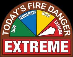
Cass County will host a National Weather Service (NWS) Storm Spotter Training Class to be held on Wednesday, March 8th, 2017 in the Courtroom of the Cass County Courthouse at 7:00 pm. Course Instructors are NWS Meteorologists who present information about identifying & reporting severe weather, spotter safety, severe weather climatology in Iowa, thunderstorm structure and threats, and more. Questions and comments directed toward these weather experts are encouraged and welcome.
This type of training has not occurred in Cass County for a couple of years. It’s FREE, requires NO REGISTRATION and is OPEN TO THE GENERAL PUBLIC.

Today: **Wind Advisory from 10-a.m. until midnight** Red Flag Warning for the far west/s.w. counties 2-p.m. to 8-p.m.**
Cloudy w/area of drizzle this morning; Showers & isolated thunderstorms this afternoon. High near 70. S @ 15-30 w/gusts to near 50 this afternoon.
Tonight: Showers ending; P/Cloudy. Low 35. NW @ 10-20.
Tomorrow: P/Cloudy. High 48. W @ 15-25.
Wednesday: P/Cldy to Cldy. High near 50.
Thursday: P/Cldy. High 52.
Sunday’s High in Atlantic was 60. Our Low this morning was 53. Last year on this date, our High in Atlantic was 72 and the low was 43. The Record High in Atlantic on this date was 74 in 2000. The Record Low was -20 in 1960.
Today: Mostly cloudy & breezy, w/patchy drizzle after 9am. High near 64. South wind 15 to 20 mph, with gusts as high as 28 mph.
Tonight: Cloudy & windy w/patchy drizzle, mainly between 9pm and midnight. Low around 54. South wind 15 to 30mph+.
Monday: Cloudy through mid-day w/a 40% chance of showers & thunderstorms; Becoming mostly sunny, with a high near 71. South wind 20 to 35mph+.
Monday Night: A 20 percent chance of showers before 9pm otherwise partly cloudy, with a low around 32. W @ 20-35+ decreasing to around 10-15 after midnight.
Tuesday: Sunny & windy. High near 53. W @ 15-35+.
Tuesday Night: Mostly clear & breezy, with a low around 28.
Wednesday: Sunny, with a high near 55.
Today: Mostly Sunny. High 64. E/SE @ 10-15.
Tonight: P/Cloudy. Low 43. S/SE @ 10-15.
Tomorrow: Mostly cloudy w/a 20% chance of showers. High 62. S/SW @ 15-30.
Sunday night: Cldy w/a 30% chance of showers. Low near 51.
Monday: Mo. Cldy w/a 40% chance of showers. High around 69.
Tuesday: Mo. Sunny. High 54.
Wednesday: Mo. Sunny. High 52.
Friday’s High in Atlantic was 46. Our Low this morning was 19. Last year on this date, our High in Atlantic was 53 and the low was 23. The Record High in Atlantic on this date was 78 in 1921. The Record Low was -17 in 1978.


