
Forecast snowy weather has prompted the Shelby County Emergency Management Agency to reduced the field/grassland Fire Danger category to “Low,” from now through Monday, when the next update will be available. Earlier this week, dry and windy conditions, as well as numerous recent grass and brush fires in Shelby County, had resulted in the Fire Danger being elevated to High.
The National Weather Service has updated the status of their Winter weather-related advisories and warnings. A Winter Weather Advisory for snow and blowing snow is now in effect from 6-a.m. Friday until Midnight, for Crawford, Carroll, Audubon, Guthrie, Cass Shelby, Pottawattamie and Mills Counties. And, a Winter Storm Warning is in effect from 6-a.m. Friday until midnight, for Monona and Harrison Counties. Further north (the northern 4 tiers of counties), a Blizzard Warning is in effect from 6-p.m. today (Thursday) through early Saturday morning.
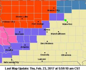
Blizzard Warning for counties in bright red; Winter Storm Warning for counties in pink; Winter Weather Advisory for counties in purple.
* TIMING…Rain will transition to snow by early Friday afternoon with winds increasing through the day on Friday. The precipitation and wind are expected to persist into early Saturday morning.
* STORM TOTAL SNOW ACCUMULATIONS…3 to 7 inches.
* WINDS/VISIBILITY…Winds becoming north to northwesterly at 20 to 30 mph with gusts over 40 mph. Visibility will be reduced to one half mile or less during periods of heavier snow and wind.
* IMPACTS…Roadways will become snow covered and blowing snow will reduce visibility creating hazardous travel conditions Friday into early Saturday morning.
PRECAUTIONARY/PREPAREDNESS ACTIONS…
A Winter Weather Advisory for blowing snow means that visibilities will be limited due to strong winds blowing snow around. Use caution when traveling, especially in open areas.
Today: Cloudy w/light rain this afternoon. High 48. NE @ 10-20.
Tonight: Cloudy w/rain. Low 34. NE @ 10-20.
Tomorrow: Cloudy w/rain-snow mix becoming all snow (1-2” possible). High 34. N @ 15-30.
Saturday: Partly Sunny. High 34.
Saturday: P/Sunny. High around 39.
Wednesday’s High in Atlantic of 71 broke the old record of 68 set in 1995. Our 24-hour Low (ending at 7-a.m. today), was 36. Last year on this date, our High in Atlantic was 46 and the low was 29. The Record High in Atlantic on this date was 65 in 2002. The Record Low was -22 in 1989.
Iowa’s flirtation with spring-like weather will be coming to an abrupt end tomorrow (Thursday). National Weather Service meteorologist Kurt Kotenberg says it will include a roughly 40-degree swing in temperatures. “Temperatures are going be back down into the 30s. I think on Saturday a lot of Iowa is going to lucky to even hit 30 degrees,” Kotenberg says. “It’s going to windy – think of those raw, windy days with winds of 20 to 30 miles an hour from the north. So, we had a small taste of spring this week, but it’s really going to flip this weekend and we’re going to see winter come back in full force.”
Rain and snow are also in the forecast. “We’re going to have that magical 32-degree line cutting right through the heart of the state from southwest to northeast,” Kotenberg says. “So, it looks like (southern) Iowa will see more rain than snow.”
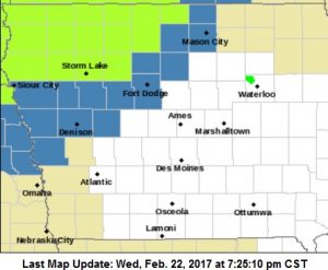
Winter Storm Watch (Counties in blue); Blizzard Watch (counties in bright green)
A Winter Storm Watch covers 14 counties in parts of western and north-central Iowa from Thursday night through Friday evening. (In the KJAN listening area, a Winter Storm Watch is in effect from 6-a.m. Friday until Midnight, for Crawford, Carroll, Harrison and Monona Counties) A Blizzard Watch is in effect for 15 counties in the northwestern 3 tiers of counties, from 6-p.m. Thursday until Midnight, Friday.
“It’s looking like, right now, portions of northwestern Iowa will hit that 6 to 10 inch range and couple places could see more than a foot of snow,” Kotenberg says. “It looks like this will be a drawn out event, as well, with the snow lasting most of Friday morning, all of Friday, and into Saturday morning.” Kotenberg notes the AMOUNT of snow won’t be the biggest factor in travel conditions — it’ll be the strong winds, with gusts up to 40 miles an hour.
“When you have any snow that falls with winds that are that strong, we could see blowing and drifting snow, visibilities well under a mile, and even snow that’s been plowed by snowplows…that can be blown back onto roadways,” Kotenberg says. The snow and cold spell won’t be hanging around too long. Temperatures are expected to climb back into the 50s by next Tuesday and Wednesday.
(Radio Iowa)
National Weather Service Omaha/Valley NE
323 PM CST Wed Feb 22 2017
Iowa Counties: Monona and Harrison
WINTER STORM WATCH IN EFFECT FROM FRIDAY MORNING THROUGH FRIDAY EVENING.
* TIMING…Rain, or a rain and snow mix on Thursday night will become all snow Friday. Snow is then expected through the day on Friday, ending on Friday evening.
* SNOW ACCUMULATIONS…Snow accumulations of 4 to 6 inches are possible from this storm system.
* WINDS…North winds of 10 to 20 mph on Thursday night are expected to become northwest 15 to 30 mph on Friday with gusts over 35 mph. This has the potentially to create blowing and drifting of the new snow.
* IMPACTS…The combination of snowfall and winds will create difficult travel from Thursday night into Friday night due to snow packed roadways and low visibility.
PRECAUTIONARY/PREPAREDNESS ACTIONS…
A Winter Storm Watch means there is a potential for significant snow, sleet, or ice accumulations that may impact travel. Continue to monitor the latest forecasts.
MONONA-HARRISON-SHELBY-POTTAWATTAMIE-MILLS-MONTGOMERY-FREMONT-PAGE COUNTIES…Wed Feb 22 2017
Very high fire danger is expected this afternoon across the area, with low humidity and strong winds creating dry conditions in fields and grassy areas. Residents are urged to avoid using motorized vehicles in fields or grassy areas, where hot exhaust pipes can spark fires. Avoid outdoor burning, and don’t carelessly discard smoking materials.
Today: Partly cloudy. High near 72.SW winds becoming NW @ 10-20.
Tonight: Partly cloudy. Low 38. NW @ 5-10.
Tomorrow: Mostly cloudy w/light rain. High 49. NE @ 10-20.
Friday: Mo. Cldy & colder w/light rain and/or snow. High 36.
Saturday: P/Cldy. High around 34.
Tuesday’s High in Atlantic of 66 broke the old record of 65 set in 1977. Our 24-hour ending today at 7-a.m. will be 30 (At 5-a.m., it was 49). Last year on this date, our High in Atlantic was 41 and the low was 27. The Record High in Atlantic on this date was 68 in 1995. The Record Low was -14 in 1894.
MONONA-HARRISON-SHELBY-POTTAWATTAMIE-MILLS-MONTGOMERY-FREMONT-PAGE Counties…Tue Feb 21 2017
The National Weather Service in Valley, NE warns of a very high fire danger that’s likely for this afternoon across the area. Open burning is strongly discouraged. Carelessly tossed cigarettes can cause ditch and field fires. Dispose of smoking materials properly.
Sac-Crawford-Carroll-Audubon-Guthrie-Cass-Adair-Adams-Taylor Counties…
546 AM CST Tue Feb 21 2017
...Areas of Fog Over the Region This Morning...
Fog continues to develop and thicken over the region early today with some areas already down to one quarter mile visibility to near zero visibility at times across west central Iowa. Light winds and abundant low level moisture along with clear skies are resulting in the fog over the area.
Persons traveling early this morning through the morning commute should be on the lookout for areas of fog…dense at times. Allow extra time to reach your destination safely. Be especially cautious near intersections and railroad crossings as vehicles and trains may be hidden from view by the thick fog. Be cautious near school bus stops as well.
The fog will lift by mid morning as much warmer air returns to the region this afternoon.
Today: Areas of fog before 9am. Otherwise, sunny, with a high near 70. Light southwest wind becoming south southwest 9 to 14 mph in the morning. Winds could gust as high as 18 mph.
Tonight: Mostly clear, with a low around 38. South southwest wind around 9 mph.
Wednesday: Sunny, with a high near 72. South southwest wind 8 to 13 mph becoming west northwest in the afternoon. Winds could gust as high as 21 mph.
Thursday: A 50 percent chance of rain after noon. Mostly cloudy, with a high near 49. Breezy. New precipitation amounts of less than a tenth of an inch possible.
Thursday Night: Rain before 4am, then rain and snow likely. Some thunder is also possible. Low around 33. Breezy. Chance of precipitation is 90%.
Friday: Rain and snow, becoming all snow after 2pm. High near 36. Windy. Chance of precipitation is 80%.
Monday’s High in Atlantic was 60 degrees, which fell short of the record by just 5 degrees. We received .18” of an inch of rain Monday, for a storm total of .43.” Our low this morning was 29. Last year on this date, our High in Atlantic was 44 and the low was 31. The Record High in Atlantic on this date was 65 in 1977. The Record Low was -19 in 1894.


