
Clarinda Police Chief Keith Brothers says with predicted snow fall amounts being difficult to forecast and snowfall amounts and computer models varying widely, he is going to err on the side of caution, and anticipates an on street parking ban to be taking effect in Clarinda sometime early Saturday morning.
Brothers said “Our snow emergency ordinance is quite simple. Once two inches of snow accumulates no on street parking is allowed. The parking ban remains in effect until the snow ceases to fall and the public works department snow plow operators have plowed the streets from curb to curb. Vehicles not moved are subject to being towed and parking tickets being issued to the vehicle’s registered owner.”
Clarinda he says, has not enacted a snow parking ban this winter season, therefore he’s anticipating a large number of violations. The key, is to stay up-to-date on the latest forecast and remember to move your vehicle off the streets when two-inches of snow has accumulated.
(6-a.m. Friday) — The National Weather Service in Johnston reports two separate snow events look to impact Iowa over the next 72 hours. The first round of snow will primarily affect Central, west and southwest Iowa from Midnight tonight through Noon, Saturday. Forecast snow amounts range from 1″ in Ames, to as much as 3″ in far southwest Iowa. Winds won’t be too much of a factor, though (Easterly at 5-10mph), but roadways could become snow covered and slippery.
The second snow event will impact the area from Noon Sunday through Noon, Monday, with 2- to 4-inches of snow from southwest through central Iowa. As much as 4-to 6-inches of snow can be expected from Ames northward, to the Minnesota border. Winds will be southeast at 10-15mph. Roadways are likely to become snow-covered and slippery. Visibility may be less than 1 mile during periods of heavier snow. The Monday morning commute may be significantly impacted!
If you have travel plans in Iowa, especially Sunday afternoon through Monday morning, make sure you are prepared for snow-covered, slippery roads & increased travel times. The rest of next week looks to be cool, with high temperatures in the 20s and 30s, and low dipping to the teens several days next week.
Today: P/Cloudy to Cloudy. High 32. NE @ 10-20.
Tonight: Cloudy w/snow developing late. Low 22. N @ 15-25.
Tomorrow: Cloudy w/snow through around Noon (1-3” total). High 28. N @ 10-15.
Sunday: Cloudy w/a 40% chance of snow/mixed precip. in afternoon. High 35.
Monday: Cloudy w/light snow or flurries. High 34
Thursday’s High in Atlantic was 49. Our Low this morning was 15. Last year on this date, our High in Atlantic was 66 and the low was 28. The Record High in Atlantic on this date was 75 in 2015. The Record Low was -8 in 1948.
The Field/Grassland Fire Danger rating in Shelby County was reduced today (Thursday), from the “Extreme,” to “High” category. The rating is in effect until the next update on Monday. Emergency management officials warn conditions will still support large fire growth, and resistance to firefighting efforts. Be sure to call 712-755-2124 if you plan to conduct an outdoor burn, and contact your local Fire Chief prior to igniting.

The experts predict run-off into the Missouri River system will be above-normal this spring, but the region is -not- expected to be hit with any flooding. Nicole Shorney, a hydraulic engineer with the U-S Army Corps of Engineers, says snow pack is very low in the upper basin due to several warm snaps and the relatively mild winter.
“The heaviest snow liquid contents range from two-to-four inches in some localized areas of central North Dakota, although the heaviest amounts are outside the Missouri River basin,” Shorney says. “Some areas of central Montana and north-central Wyoming also have remaining Plains snow that has less than an inch of liquid content. The rest of the upper basin has no Plains snow remaining.”
Shorney says run-off so far this year has been above-normal. “February run-off was more than double its average due to Plains snow melt from much warmer-than-normal February temperatures,” Shorney says. “Focusing on the March-to-July run-off season, the time when we see our highest run-off, we’re expecting March run-off to be slightly above-average for the upper basin as the remainder of the Plains snow pack enters the system.”
Shorney says they expect slightly above-normal run-off into late spring. “For the Oahe to Sioux City regions, we’re forecasting normal run-off for the April-to-July period,” she says. “Our annual run-off forecast is 29.1-million acre feet or 115-percent of normal.”
Corps officials say all of the water in the flood storage of the reservoirs has been sent downstream. Releases from Gavins Point Dam will increase later this month to support downstream navigation.
(Radio Iowa)
MARY LOUISE HANSEN, 97, of Council Bluffs, died Tuesday, March 7th, at Bethany Lutheran Home. A Mass of Christian Burial for MARY LOUISE HANSEN will be held 10:30-a.m. Saturday, March 11th, at St. Patrick’s Catholic Church in Walnut. Pauley-Jones Funeral Home in Avoca has the arrangements.
Visitation at the funeral home, is on Friday, March 10th, from 5-until 8-p.m., with a Prayer Service at 7-p.m.
Burial will be in the St. Patrick’s Cemetery at Walnut.
MARY LOUISE HANSEN is survived by:
Her daughters – Judith (Delbert) Brehmer, of Council Bluffs, & Rosemary (Bill) Steinkamp, of Bellingham, WA.
Her sons – Jerry Hansen, and Ronald (Nancy) Hansen, all of Walnut.
Her brother – Gerald Martin, of Exira.
7 grandchildren, 16 great-grandchildren, and 2 great-great grandchildren.
Today: P/Cloudy to Cloudy. High near 50. NE @ 10-15.
Tonight: Mostly Cloudy. Low 22. N @ 15-25.
Tomorrow: Mo. Cloudy. High 34. N @ 15-25.
Tomorrow night: Snow developing mainly after midnight. Low 18.
Saturday: Cloudy w/a 50% chance of snow in the morning. High 28.
Sunday: Cloudy w/a 40% chance of snow or mixed precip. in the afternoon. High 33.
Wednesday’s High in Atlantic was 55. Our Low this morning (as of 5-a.m.) was 29. Last year on this date, our High in Atlantic was 59 and the low was 27. The Record High in Atlantic on this date was 76 in 1986. The Record Low was -10 in 1912.
DES MOINES, Iowa (AP) — The Iowa Department of Agriculture says last month was the second warmest February on record in the state with an average temperature of 34 degrees, 10 degrees above normal. That average was exceeded only by February 1954 when the average temperature was 35 degrees.
Last month is the only Iowa February on record to post eight days of 70-degree weather. The warmth is forcing unusually early plant emergence. Ottumwa recorded the highest temperature with 79 degrees on the 22nd, a February reading exceeded only in 1972 when Sidney reported 82 degrees and in 1930 when Clarinda and Mount Ayr posted 80.
State Climatologist Harry Hillaker says a brief tornado on Feb. 28 in Clinton County also was a February rarity. The only previous February tornadoes were in 1922 and 1977.
This past February was the second warmest in Iowa on record. The Iowa Department of Natural Resources says the warm start to the year is prompting vegetation to come out of dormancy sooner than usual and could intensify the dry conditions across south central and southeast Iowa due to early evapotranspiration. The report is prepared by the technical staff from the Iowa DNR, the Iowa Department of Agriculture and Land Stewardship, IIHR—Hydroscience and Engineering and the U.S. Geological Survey, in collaboration with The Iowa Homeland Security and Emergency Management Department.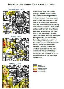
Officials say Hydrologic conditions and drought have remained the same throughout the winter months in Iowa. The pattern of wetness in northern Iowa and the dryness in the southern half has changed very little throughout the winter.
Precipitation for Iowa varied across the state. The wettest area of the state is far northern Iowa, receiving double the normal amounts for January and February, while the southeast one-third of the state remains dry. Stream flow conditions are above normal across the majority of the state, except in parts of southern Iowa, which have decreased to normal levels.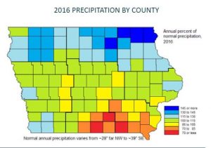
For a thorough review of Iowa’s water resource trends, go to www.iowadnr.gov/watersummaryupdate.
Today: P/Cloudy. High near 58. SW @ 10-15.
Tonight: P/Cloudy. Low 30. W @ 5.
Tomorrow: P/Cloudy. High 53. N @ 10-20.
Friday: Cloudy. High 34.
Saturday: Cldy w/an 80% chance of snow. High near 30.
Tuesday’s High in Atlantic was 56. Our Low this morning was 27. Last year on this date, our High in Atlantic was 68 and the low was 30. The Record High in Atlantic on this date was 76 in 1986. The Record Low was -12 in 1982.


