
845 PM CDT WED APR 19 2017
The National Weather Service in Des Moines has issued a
* Severe Thunderstorm Warning for…
Central Cass County in southwestern Iowa…
Adair County in southwestern Iowa…
* Until 930 PM CDT.
* At 845 PM CDT, a severe thunderstorm was located 8 miles southeast
of Atlantic, moving northeast at 40 mph.
HAZARD…60 mph wind gusts and quarter size hail.
SOURCE…Radar indicated.
IMPACT…Hail damage to vehicles is expected. Expect wind damage
to roofs, siding, and trees.
* Locations impacted include…
Greenfield, Anita, Adair, Fontanelle, Lewis, Massena, Cumberland,
Bridgewater, Wiota, Lake Anita State Park, Greenfield Municipal
Airport, Nodaway Park, Cold Springs State Park and Anita Municipal
Airport.
This includes Interstate 80 between mile markers 71 and 85.
PRECAUTIONARY/PREPAREDNESS ACTIONS…
Remain alert for a possible tornado! Tornadoes can develop quickly
from severe thunderstorms. If you spot a tornado go at once into the
basement or small central room in a sturdy structure.
For your protection move to an interior room on the lowest floor of a
building.
814 PM CDT WED APR 19 2017
The National Weather Service in Des Moines has issued a
* Severe Thunderstorm Warning for…
Southwestern Greene County in west central Iowa…
Guthrie County in west central Iowa…
Audubon County in west central Iowa…
Southeastern Carroll County in west central Iowa…
* Until 900 PM CDT.
* At 814 PM CDT, a severe thunderstorm was located 7 miles north of
Audubon, moving east at 45 mph.
HAZARD…60 mph wind gusts and quarter size hail.
SOURCE…Radar indicated.
IMPACT…Hail damage to vehicles is expected. Expect wind damage
to roofs, siding, and trees.
* Locations impacted include…
Jefferson, Audubon, Guthrie Center, Coon Rapids, Panora, Lake
Panorama, Exira, Elk Horn, Scranton, Bayard, Kimballton, Bagley,
Dedham, Yale, Jamaica, Brayton, Gray, Jefferson Municipal Airport,
Lakin Slough Game Management Area and Audubon County Airport.
PRECAUTIONARY/PREPAREDNESS ACTIONS…
Remain alert for a possible tornado! Tornadoes can develop quickly
from severe thunderstorms. If you spot a tornado go at once into the
basement or small central room in a sturdy structure.
For your protection move to an interior room on the lowest floor of a
building.
723 PM CDT WED APR 19 2017
THE NATIONAL WEATHER SERVICE HAS EXTENDED TORNADO WATCH 148 TO INCLUDE THE FOLLOWING AREAS UNTIL 10 PM CDT THIS EVENING IN IOWA THIS WATCH INCLUDES 3 COUNTIES IN WEST CENTRAL IOWA: CARROLL CRAWFORD GREENE
THIS INCLUDES THE CITIES OF CARROLL, DENISON, AND JEFFERSON.
* PRIMARY THREATS INCLUDE…
A FEW TORNADOES LIKELY.
SCATTERED LARGE HAIL AND ISOLATED VERY LARGE HAIL EVENTS TO 2.5 INCHES IN DIAMETER LIKELY. ISOLATED DAMAGING WIND GUSTS TO 70 MPH POSSIBLE.
TORNADO WATCH 148 REMAINS VALID UNTIL 10 PM CDT THIS EVENING FOR THE FOLLOWING AREAS: ADAIR ADAMS AUDUBON CARROLL CASS CRAWFORD FREMONT GREENE GUTHRIE HARRISON MILLS MONONA MONTGOMERY PAGE POTTAWATTAMIE SHELBY TAYLOR
Severe Thunderstorm Warning
National Weather Service Omaha/Valley Nebraska
728 PM CDT WED APR 19 2017
The National Weather Service in Omaha has issued a
* Severe Thunderstorm Warning for…
Northeastern Harrison County in southwestern Iowa…
Shelby County in southwestern Iowa…
* Until 800 PM CDT
* At 728 PM CDT, a severe thunderstorm was located 9 miles northeast
of Logan, or 25 miles southwest of Denison, moving east at 35 mph.
HAZARD…60 mph wind gusts and quarter size hail.
SOURCE…Radar indicated.
IMPACT…Hail damage to vehicles is expected. Expect wind damage
to roofs, siding, and trees.
* Locations impacted include…
Harlan, Earling, Irwin, Defiance, Woodbine, Panama, Portsmouth,
Westphalia, Kirkman and Schaben Park.
This includes Highway 59 IN Iowa between mile markers 80 and 89.
PRECAUTIONARY/PREPAREDNESS ACTIONS…
For your protection move to an interior room on the lowest floor of a
building.
The National Weather Service has issued Tornado Watch #148 in effect until 10-p.m. for the following area Counties ADAIR ADAMS AUDUBON CASS FREMONT GUTHRIE HARRISON MILLS MONONA MONTGOMERY PAGE POTTAWATTAMIE SHELBY TAYLOR.
The Primary threats include a few likely tornadoes, scattered large hail, and isolated very large hail events to 2.5-inches in diameter. Isolated damaging wind gusts of up to 70-mph are also possible. 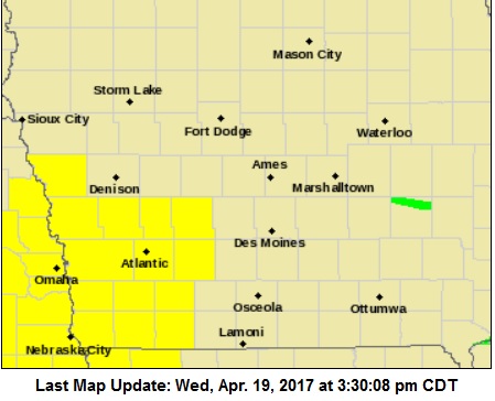
Tornado probability:
2 or more tornadoes = 60%
1 or more strong tornadoes (F-2 to F-5) = 20%
10 or more severe wind events + 20%
1 or more wind events exceeding 75 mph = 10%
10 or more severe hail events = 60%
1 or more hail events (>2″) = 60%
hail/wind events = 90%
Baseball Camps for Atlantic Little League have been cancelled for today (4/19)
The entire state is under the threat for severe thunderstorms later today (Wednesday). National Weather Service Meteorologist Cory Martin says the system is expected to enter western Iowa late this afternoon and push east through the evening and into the early overnight hours. “All modes of severe weather are possible including large hail, strong wind gusts, and also the possibility of a few tornadoes,” Martin said.
The biggest tornado threat appears to be over west-central and southwest Iowa, according to Martin. Heavy rain is also likely. “It remains to be seen if it’s going to lead to any flash flooding concerns. It looks like the storms will be moving at a decent clip. That would alleviate any threat for flash flooding, but it’s something that we’ll monitor,” Martin said.
Dry and cooler conditions are expected for the remainder of the work week and into the weekend.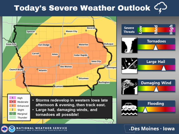
(Radio Iowa)
AREA COUNTIES: Audubon-Guthrie-Dallas-Cass-Adair-Madison-Adams-Union-Taylor-Ringgold-934 AM CDT Wed Apr 19 2017
…FLASH FLOOD WATCH IS CANCELLED...
The Flash Flood Watch for portions of central Iowa, south central Iowa, southeast Iowa, southwest Iowa, and west central Iowa has been cancelled. Rainfall last night was lighter and less widespread than expected. Thus the flash flood threat has
diminished. Local minor flooding is possible later today into tonight due to additional thunderstorms. Widespread flash flooding is not expected however.
Today: FLASH FLOOD WATCH until 1-a.m. Thursday; Scattered showers & thunderstorms. High 70. SE @ 15-25.
Tonight: Scattered shwrs & tstrms. Low 48. S-NW @ 10-15.
Tomorrow: P/Cldy. High 62. NW @ 10-20.
Friday: P/Cldy High 62.
Saturday: P/Cldy to Cldy. High around 62.
Tuesday’s High in Atlantic was 67. Our Low this morning (as of 5:15-a.m.) was 52. We have also received .35” of an inch of rain from yesterday (.19”) and early this morning (.16”) at the KJAN studios. Last year on this date, the High in Atlantic was 62 and the low was 44. The Record High in Atlantic on this date was 87 in 1908, 1946 & 1987. The Record Low was 15 in 1988.


