
Today: Partly cloudy. High 53. NW @ 10-20.
Tonight: P/Cldy to Cloudy. Low 32. E @ 5-10.
Tomorrow: Mostly cloudy w/rain. High 38. E @ 15-25.
Tom. Night: Rain changing to snow. Freezing rain possible toward sunrise, & patchy blowing snow. Low 26. N/NE winds becoming NW @ 20- to 40 mph. Little or no ice accumulation expected. New snow accumulation of 1 to 2 inches possible.
Wednesday: Cldy w/light snow & blowing snow in the morning. High 32.
Thanksgiving Day: Cldy w/light rain in the afternoon. High 36.
Sunday’s High in Atlantic was 57. Our Low this morning was 26. Last year on this date, the High in Atlantic was 29 and the Low was 14. The record High for Nov. 25th in Atlantic, was 71 in 1960. The Record Low was -6 in 1991.
Area Counties: Sac-Crawford-Carroll…WINTER STORM WATCH IN EFFECT FROM 6-P.M. TUESDAY until NOON WEDNESDAY
* WHAT…Heavy snow possible along with strong winds. Total snow accumulations of 4 to 8 inches possible. Highest amounts expected near the Minnesota border. Winds could gust of 35 to 45 mph will be possible.
* IMPACTS…Travel could be very difficult. Areas of blowing snow could significantly reduce visibility. The hazardous conditions could impact the morning or evening commute.
* ADDITIONAL DETAILS…Near blizzard conditions may exist early Wednesday morning from the combination of falling snow and strong north winds. Be prepared very poor conditions early
Wednesday morning in the watch area.
PRECAUTIONARY/PREPAREDNESS ACTIONS…
Monitor the latest forecasts for updates on this situation.
The National Weather Service in Johnston says moderate snow is forecast to develop over portions of west-central to northern Iowa during the afternoon hours Tuesday and continue into early Wednesday morning. The greatest snowfall rates are likely to occur Tuesday evening. A rain/snow line is likely to set up from Waterloo to Des Moines to southwest portions of Iowa.
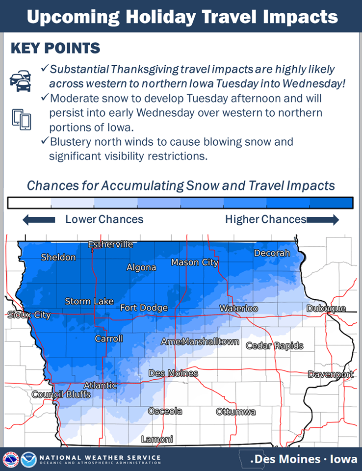
click to enlarge the graphic
Anything northwest of that line is likely to receive the accumulating snow. In addition to the snow, north winds of 25 to 35 mph are likely by Tuesday night and look to persist throughout the day Wednesday resulting in blowing snow and visibility restrictions. Hazardous travel is anticipated due to snow covered and slick roads along with the visibility restrictions.
If traveling Tuesday into Wednesday over portions of western and northern Iowa into Minnesota, please consider rescheduling.
Today: Sunny, with a high near 56. West wind 5 to 10 mph.
Tonight: Mostly clear, with a low around 34. Southwest wind around 5 mph becoming calm after midnight.
Monday: Mostly sunny, with a high near 54. Light west northwest wind becoming northwest 5 to 10 mph in the morning.
Tuesday: A chance of snow before 9am, then a chance of rain and snow between 9am and 10am, then rain likely after 10am. Cloudy, with a high near 43. Breezy, with a northeast wind 8 to 16 mph, with gusts as high as 28 mph. Chance of precipitation is 60%. Little or no snow accumulation expected.
Tuesday Night: Rain before 7pm, then rain and snow between 7pm and 8pm, then snow after 8pm. Low around 25. Blustery. Chance of precipitation is 80%. New precipitation amounts between a quarter and half of an inch possible.
Wednesday: Partly sunny, with a high near 37. Breezy.
Wednesday Night: A 20 percent chance of snow after midnight. Mostly cloudy, with a low around 21.
Thanksgiving Day: A chance of rain and snow before 5pm, then a chance of snow. Cloudy, with a high near 37. Chance of precipitation is 30%.
Skyscan Forecast Saturday, November 23, 2019 Dan Hicks
Today: Partly cloudy. W @ 10. High 48.
Tonight: Fair to partly cloudy. W @ 5. Low 26.
Sunday: Partly cloudy. Warmer. SW 10-15. High 56.
Monday: Partly cloudy. High 49.
Tuesday: Cloudy. Rain and snow mix. High 36.

Podcast: Play in new window | Download (512.9KB)
Subscribe: RSS
(Radio Iowa) — The latest update from the state finds the amount of precipitation in the “Water Year” for the state is well above normal. The D-N-R’s Tim Hall says the Water Year runs from Iowa from October of last year to the end of September this year. He says it’s defined that way because after September, there’s no moisture that benefits the current growing season. The current water year saw a little more than 42-and-a-half inches of precipitation. “We are about seven inches above average,” Hall says, “if you go back and you look at 24 months — the water years of 2018 and 2019 together — we’re pushing 20 inches above normal for those two year. So, it’s been a very, very wet couple of years.”
The ground is full of water right now, and that can be a positive.”Generally in the fall going into the winter, having a wet soil profile is good — because it benefits us in the spring when the vegetation wants to get kicked off,” according to Hall. But he says if the ground stays saturated and we have a wet spring the wet soil profile can become a bad thing. “There’s sort of some early precautionary flags being raised that we could find ourselves in a flood situation in the spring, depending on what happens in the winter,” Hall says.
Hall says it’s a waiting game that depends on how much snow we get — and how much remains in the spring when it starts to melt. “As we sit here today it could be a good thing — it could be a bad thing. It depends on what happens over the next three or four months,” Hall says. Wet ground delayed planting this last spring and that led to a delayed harvest for this year’s crop. This was the seventh wettest and 45th warmest Water Year among 147 years of Iowa records. The back-to-back water years of 2018 and 2019 was the third wettest combined two years on record.
Today: Partly cloudy. High 44. N winds at 5-10 mph.
Tonight: Partly cloudy to cloudy. Low 27.
Tomorrow: P/Cldy. High 48. W @ 10-15.
Sunday: P/Cldy. High 54.
Monday: Mo. Cldy w/isolated showers possible. High 45.
Thursday’s High in Atlantic was 40. Our Low this morning was 17. Last year on this date, the High in Atlantic was 57 and the Low was 24. The record High for Nov. 22nd in Atlantic, was 69 in 1966. The Record Low was -10 in 1937.
Today: Mostly cloudy w/scattered light rain this morning, & temps falling into the 30’s before rebounding this afternoon to around 42. NW winds at 15-30 mph.
Tonight: Partly cloudy. Low 20. NW @ 5-10.
Tomorrow: P/Cldy. High 44. N @ 5-10.
Saturday: P/Cldy. High 48.
Sunday: P/Cldy. High 54.
Wednesday’s High in Atlantic was 62. Our Low was 30. As of 5-a.m. in Atlantic, we had received .38″ rainfall. Last year on this date, the High was 51 and the Low 20. The All-Time record High in Atlantic on Nov. 21st, was 71 in 1990. The record Low was -14 in 1937.
Today: Partly cloudy to cloudy. High 58. S/SE winds at 15-25 mph.
Tonight: Cloudy w/showers & possible thunderstorms. Low 40. S winds becoming NW @ 10-20.
Tomorrow: Mostly cloudy w/rain ending in the morning. High 42. N @ 15-30.
Friday: P/Cldy. High 44.
Saturday: P/Cldy. High 42.
Tuesday’s High in Atlantic was 58. Our Low, 30. Last year on this date, the High was 38 and the Low 12. The All-Time record High in Atlantic on Nov. 20th, was 75 in 1933. The record Low was -1 in 1937 & 1985.


