
Skyscan Forecast Saturday, December 21, 2019 Dan Hicks
Today: Patchy fog early, then partly sunny. SW @ 10-20. High 50.
Tonight: Partly cloudy. S @ 5-10. Low 28.
Sunday: Mostly sunny. SW @ 10-20. High 55.
Sunday night: Partly cloudy. Low 31.
Monday: Partly cloudy. High 53.
Tuesday: Partly cloudy. High 49.

Podcast: Play in new window | Download (558.5KB)
Subscribe: RSS
Today: Areas of fog this morning; Partly cloudy. High 48. S @ 10-15.
Tonight: Fair to Partly cloudy. Low 25. S @ 5.
Tomorrow: Mostly sunny. High 50. S @ 10-20.
Sunday: Mo. Sunny. High 53.
Monday: P/Cldy. High near 50.
Thursday’s High in Atlantic, was 48. Our Low was 22. Last year on this date, the High in Atlantic was 37 and the Low was 28. The record High for Dec. 20th in Atlantic, was 61 in 1941. The Record Low was -25 in 1901.
Today: Areas of fog this morning; Mostly sunny. High 50. SW @ 15-25.
Tonight: Fair to Partly cloudy. Low 28. S @ 5-10.
Tomorrow: P/Cldy. High 47. S @ 10-15.
Saturday: P/Cldy. High 50.
Sunday: P/Cldy. High around 52.
Wednesday’s High in Atlantic, was 35. Our Low was 9. Last year on this date, the High in Atlantic was 50 and the Low was 34. The record High for Dec. 19th in Atlantic, was 58 in 1966. The Record Low was -33 in 1983.
Today: Mostly sunny. High 33. N-SE @ 10-15.
Tonight: Fair to Partly cloudy. Low 20. SW @ 5-10.
Tomorrow: P/Cldy & windy. High 50. SW @ 15-25.
Friday: P/Cldy. High 47.
Saturday: P/Cldy. High around 50.
Tuesday’s High in Atlantic, was 36. Our Low this morning, 10. Last year on this date, the High in Atlantic was 52 and the Low was 35. The record High for Dec. 18th in Atlantic, was 66 in 1976. The Record Low was -28 in 1983.
Today: Areas of dense fog this morning; Becoming Partly cloudy. High 35. W @ 10-15.
Tonight: P/Cldy. Low 15. N @ 10.
Tomorrow: P/Cldy. High 33. SE @ 10.
Thursday: P/Cldy. High 49.
Friday: P/Cldy. High 49.
Monday’s High in Atlantic, was 25. Our Low was 16. Last year on this date, the High in Atlantic was 46 and the Low was 18. The record High for Dec. 17th in Atlantic, was 65 in 1939. The Record Low was -18 in 1951.
Today: Areas of fog this morning; Partly cloudy. High 27. N @ 10.
Tonight: Mostly clear. Low 10. Winds light & variable.
Tomorrow: Mostly sunny. High 35. W @ 10-15.
Wednesday: P/Cldy. High 35.
Thursday: P/Cldy. High 47.
Sunday’s High in Atlantic was 20. We received .6″ snow (.04″ melted precip.). Our Low this morning was 10. Last year on this date, we reached 44 for the High and 18 was the Low. The All-time Record High for Dec. 16th in Atlantic, was 59 in 1962. The Record Low was -22 in 1951.
Today: A 50 percent chance of snow after 11am. Cloudy, with a high near 23. Wind chill values as low as zero. East wind 3 to 6 mph. Total daytime snow accumulation of less than a half inch possible.
Tonight: A 30 percent chance of snow, mainly before 8pm. Cloudy, then gradually becoming partly cloudy, with a low around 12. East wind around 5 mph becoming calm in the evening. New snow accumulation of less than a half inch possible.
Monday: Partly sunny, with a high near 29. Wind chill values as low as 5. North northwest wind 3 to 7 mph.
Monday Night: Partly cloudy, with a low around 12. North northwest wind 3 to 6 mph.
Tuesday: Sunny, with a high near 34. West wind 5 to 10 mph.
Tuesday Night: Mostly clear, with a low around 12.
Wednesday: Sunny, with a high near 38.
Saturday’s High in Atlantic, was 23. Our Low this morning, 12 (as of 6-a.m.). Last year on this date, the High in Atlantic was 44 and the Low was 14. The record High for Dec. 15th in Atlantic, was 64 in 2002. The Record Low was -19 in 1901.
The National Weather Service in Des Moines “It was just a matter of time, but it is mid-December in Iowa and we’re expecting snow across southern Iowa Sunday into Monday.” Officials say the snow looks develop over far western Iowa late Sunday morning and gradually spread east over the rest of southern Iowa and portions of northern Missouri during the afternoon and evening hours Sunday. Accumulating snow is likely along and south of Interstate 80 and the highest snowfall is anticipated along and south of Highway 34 to the Missouri border.One-to 2 inches of snow are possible here in the Atlantic area. 
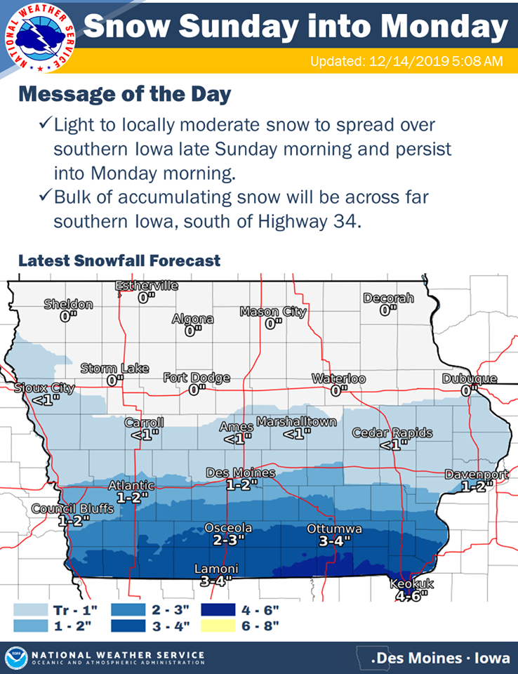
The period of time when the bulk of the snow will accumulate is expected to be late Sunday afternoon through late Sunday evening. Lingering snow is possible through late Monday morning across the southeast. Snow covered and very slick roads can be expected by Sunday evening and into Monday, impacting the morning commute. After this storm rolls through the state, the rest of the week will be dry and mild.
Fremont-Page Counties…WINTER WEATHER ADVISORY IN EFFECT FROM 6 AM SUNDAY TO 6 PM MONDAY…
* WHAT…Snow expected. Total snow accumulations of 2 to 5 inches.
* IMPACTS…Plan on slippery road conditions. The hazardous conditions could impact the morning or evening commute.
PRECAUTIONARY/PREPAREDNESS ACTIONS…
Slow down and use caution while traveling. The latest road conditions for the state you are calling from can be obtained by calling 5 1 1.
Today: Partly cloudy to cloudy. High 24. N @ 10-20.
Tonight: P/Cldy to Cldy. Low 10. NW @ 5.
Tomorrow: Mo. Cldy w/light snow, mainly in the afternoon. High 23. E @ 10.. (new snow accumulation around 1 inch possible).
Sunday Night: Light snow. (New snow around 1″ possible). Lowq 13.
Monday: A chance of flurries, otherwise Partly Sunny. High 27.
Tuesday: P/Cldy. High 29.
Friday’s High in Atlantic, was 39 We received a Trace of rain/freezing rain at times. Our Low was 20. Last year on this date, the High in Atlantic was 41 and the Low was 15. The record High for Dec. 14th in Atlantic, was 59 in 1975. The Record Low was -19 in 1901 & 1972.


