
The Iowa Dept. of Transportation’s 511ia.org website indicates most roads in the KJAN listening area (as of 6:15-a.m.) were either partially or completely covered with snow, but there were no traffic disruptions reported due to the road conditions. Slow down, and drive with caution, as the snow packed roads are making for tricky travel in some spots. For the latest road report throughout the day, call 5-1-1 (in Iowa) or go to 511ia.org, on the web.
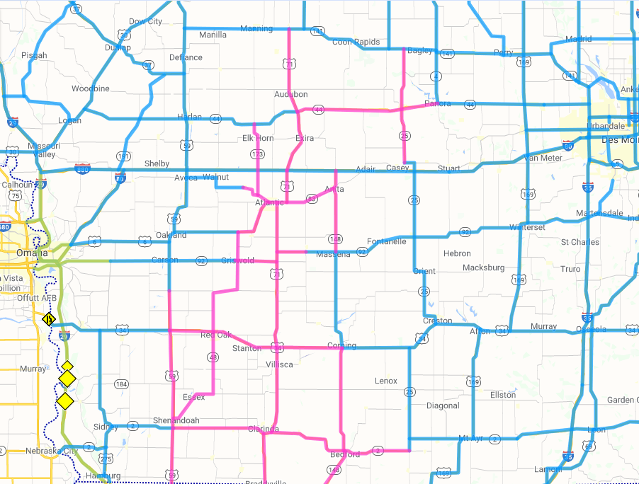
Blue=Road partially covered w/snow; Pink=Road completely covered with snow.
Today: Light snow ending this morning; Mostly cloudy. High 28. E/SE @ 5-10 mph.
Tonight: Mo. Cldy. Low 32. Winds light & variable.
Tomorrow: Mo. Cldy. High 34. S/SE @ 5-10.
Friday: P/Cldy. High 42.
Tuesday’s High in Atlantic (the 24-hour High ending 7-a.m. today), was 25. The Low was 27. We had received .8″ of snow overnight, which melted into .07″ liquid precipitation. Last year on this date, the High in Atlantic was 6 and the Low was -19. The Record High in Atlantic on Jan. 29th, was 59 in 1931. The Record Low was -31, in 1904.
Today: Mostly cloudy. Areas of fog, freezing drizzle or flurries this morning. High around 30. N @ 5-10.
Tonight: Mo. Cldy w/light snow developing late. Low 28.
Tomorrow: Cldy w/light snow in the morning (<1” total). High 28. NE @ 5-10.
Thursday: Mostly cloudy. High 32. Friday: Mo. Cldy w/scattered light snow or flurries. High 34.
Monday’s High in Atlantic was 34. Our Low this morning (as of 5:10-a.m.) was 27. Last year on this date, the High in Atlantic was 14 and the Low was 1. The record High for Jan. 27th in Atlantic, was 58 in 1931 & 2015. The Record Low was -23 in 1915.
Today: Partly cloudy to cloudy. High near 34. N wind 10 to 15 mph.
Tonight: P/Cldy to Cldy. Low around 20. N @ 5-10.
Tomorrow: P/Cldy to Cldy. High 30. N @ 5-10.
Wednesday: Mostly cloudy, w/light snow possible in the morning. High 28. Thursday: P/Cldy. High 34.
Sunday’s High in Atlantic was 32. Our Low was 24. Last year on this date, the High in Atlantic was 28 and the Low was 6. The record High for Jan. 27th in Atlantic, was 61 in 1939. The Record Low was -31 in 1902.
Today: **DENSE FOG ADVISORY until 10-a.m.** Areas of dense fog before noon. Areas of dense freezing fog between 7am and 10am. Otherwise, cloudy, then gradually becoming mostly sunny, with a high near 34. West wind 3 to 7 mph.
Tonight: Patchy fog between midnight and 1am. Otherwise, mostly cloudy, with a low around 20. West wind around 7 mph.
Monday: Cloudy, with a high near 31. North northwest wind 5 to 7 mph.
Monday Night: Cloudy, with a low around 20. Light north wind.
Tuesday: Cloudy, with a high near 29.
Wednesday: Mostly cloudy, with a high near 32.
Saturday’s High in Atlantic was 33. Our Low was 25. Last year on this date, the High in Atlantic was 31 and the Low was 4. The record High for Jan. 26th in Atlantic, was 67 in 2002. The Record Low was -24 in 1963.
Today: Mostly cloudy this morning; P/Cldy this afternoon. High 32. W @ 10-15.
Tonight: P/Cldy. Low 18. W @ 5.
Tomorrow: P/Cldy. High 35. W @ 10.
Monday: P/Cldy. High 33.
Tuesday: P/Cldy. High 33.
Friday’s High in Atlantic was 32. Our Low 27. Last year on this date, the High in Atlantic was 27 and the Low was 2. The record High for Jan. 25th in Atlantic, was 65 in 1944. The Record Low was -28 in 1894.
Today: A chance of snow and freezing drizzle before 9am, then a chance of snow between 9am and 4pm. Patchy fog before noon. Otherwise, cloudy, with a high near 30. Blustery, with a north wind 10 to 16 mph, with gusts as high as 23 mph. Chance of precipitation is 30%. Little or no snow accumulation expected.
Tonight: Cloudy, with a low around 18. Northwest wind 6 to 9 mph.
Tomorrow: Mostly cloudy, with a high near 28. West northwest wind 3 to 8 mph.
Tom. Night:: Mostly cloudy, with a low around 14. Calm wind.
Sunday: Mostly cloudy, with a high near 31.
Sunday Night: Mostly cloudy, with a low around 20.
Monday: Partly sunny, with a high near 32.
Thursday’s High in Atlantic was 36. Our Low 30. We received a little more than a trace of snow and drizzle yesterday. Last year on this date, the High in Atlantic was 23 and the Low was -12. The record High for Jan. 24th in Atlantic, was 66 in 1981. The Record Low was -24 in 1894.
Today: **Dense Fog Advisory in effect until Noon** Cloudy w/dense fog this morning, light snow and/or freezing drizzle. High 34. NW @ 10-15.
Tonight: Cloudy w/light snow & patchy fog. Low 28. N @ 10-20.
Tomorrow: Mo. Cldy w/light snow possible in the morning. High 32. NW @ 10-20.
Saturday: P/Cldy. High 36.
Sunday: P/Cldy. High 34.
Our 24-hour High in Atlantic (as of 5:45-a.m. Today) was 33. Our 24-hour was 32. We received 1.3-inches of snow and mixed precipitation Wednesday thru early this morning. Last year on this date, the High in Atlantic was 25 and the Low was 11. The record High for Jan. 23rd in Atlantic, was 60 in 1981. The Record Low was -24 in 1948.
(Radio Iowa) — Climate observers are renewing their warning of conditions that could lead to another round of widespread flooding this spring, especially in the Missouri River valley. Doug Kluck, the Central Region climate service director for the National Weather Service in Kansas City, says there is a lot of water locked up across the region. “It’s hard to get rid of a lot of water during this time of year,” Kluck says. “We don’t have a lot of evaporation, the plants aren’t growing. Whatever was there in October and November and December and now January isn’t going very far. The rivers keep flowing to some degree, some are frozen up. This is an accumulation time of year.”
Kluck says the updated forecasts are not optimistic as they predict a continued cold, wet winter. “The outlooks aren’t helpful from that perspective,” Kluck says. “Below normal temperatures will close things down in terms of freezing and not melting. The above-normal precipitation signatures, if that were to come true, aren’t helpful either.” Kluck says if snowfall for the remaining two months of winter is relatively average, that may also spell trouble. “Even normal precipitation this time of year through spring and early summer, normal kind of ramps up,” Kluck says. “So normal precipitation probably wouldn’t be a great thing either for most of the north-central part of the U.S. either.”
Significant flooding started in northwest Iowa in March of last year and some residents of the area still haven’t been able to return to their homes — after ten months.
TODAY: **Winter Weather Advisory until 6-p.m.**Snow, mixed at times with rain. High 35. S @ 10-20. (1-2” snow possible)
TONIGHT: Cloudy w/light snow-rain mixed. Low 32.
TOMORROW: Cloudy w/light snow-rain mix. High 34. NW @ 10-20
FRIDAY: Cldy w/light snow. High 32.
SATURDAY: P/cldy. High 36.
Our 24-hour High in Atlantic (as of 7-a.m. Today) was 34. Our 24-hour was -8. We received a mix of mostly snow and some light rain/freezing rain overnight. As of 7-a.m. today we had .4″ snow and about .1″ ice on the ground under the snow (total 1/2″). Last year on this date, the High in Atlantic was 29 and the Low was 12. The record High for Jan. 22nd in Atlantic, was 60 in 1967. The Record Low was -27 in 1930.


