
425 PM CST Sat Nov 30 2019 – The National Weather Service in Des Moines has issued a Tornado Warning for…Northeastern Guthrie County in west central Iowa…West central Dallas County in central Iowa until 445 PM CST.
* At 424 PM CST, a severe thunderstorm capable of producing a tornado was located near Panora, or 10 miles east of Guthrie Center, moving northeast at 25 mph.
SOURCE…Radar indicated rotation.
IMPACT…Flying debris will be dangerous to those caught without shelter. Mobile homes will be damaged or destroyed. Damage to roofs, windows, and vehicles will occur. Tree damage is likely.
* This tornadic thunderstorm will remain over mainly rural areas of northeastern Guthrie and west central Dallas Counties, including the following locations… Lakin Slough Game Management Area.
PRECAUTIONARY/PREPAREDNESS ACTIONS…
TAKE COVER NOW! Move to a basement or an interior room on the lowest floor of a sturdy building. Avoid windows. If you are outdoors, in a mobile home, or in a vehicle, move to the closest substantial shelter
and protect yourself from flying debris.
Sac-Crawford-Carroll-Audubon-Guthrie-Cass-Adair-Adams-Union-Taylor-Ringgold–
…WIND ADVISORY IN EFFECT FROM 3 AM TO NOON CST SUNDAY…
* WHAT…Northwest winds 25 to 35 mph with gusts up to 45 mph expected.
* IMPACTS…Gusty winds could blow around unsecured objects. Tree limbs could be blown down and a few power outages may result.
Monona-Harrison-Shelby-Pottawattamie-Mills-Montgomery-Fremont-Page-Counties…
…WIND ADVISORY IN EFFECT FROM 10 PM THIS EVENING TO NOON CST SUNDAY…
* WHAT…Northwest winds 25 to 35 mph with gusts up to 50 mph expected.
PRECAUTIONARY/PREPAREDNESS ACTIONS…
Use extra caution when driving, especially if operating a light or high
profile vehicle. Secure outdoor objects.
KANSAS CITY, Mo. (AP) — After a year that has seen some of the worst flooding ever in parts of the Midwest, concern is already rising that the spring of 2020 may bring more high water to places that still haven’t fully recovered.
Flooding ravaged much of the Missouri and Mississippi River basins earlier this year, reaching record levels in many places. Eight months later, parts of the Missouri River are above flood stage at a time of the year when river levels traditionally run low. Conditions are only slightly better on the Mississippi River.
High river levels aren’t the only worry. National Weather Service hydrologist Mark Fuchs cites two other factors: Soil is extremely saturated in several upper Midwestern states, and the long-range forecast offers a strong possibility of a wetter-than-normal winter.
Skyscan Forecast for Saturday, November 30, 2019 from Dan Hicks:
Saturday: Partly cloudy to cloudy with light rain and drizzle in the morning, SSE winds switching to the north at 10-20 mph, high 50.
Saturday night: Partly cloudy to cloudy with light rain changing to light snow, north wind 10-20 mph, low 32.
Sunday: Partly cloudy to cloudy and windy with light flurries, winds from the north at 20-35 mph, high 34.
Monday: Partly cloudy with a high of 42.
Tuesday: Partly cloudy with a high of 48.
Friday’s high was 38 while this morning’s low was 32. In the 24 hour period ending Saturday at 7:00 am we had received .13″ of rain.
Skyscan Forecast Friday, November 29, 2019 Dan Hicks
Today: Cloudy. Fog and drizzle in the morning, light rain in the afternoon. SE @ 10-20. High 40.
Tonight: Mostly cloudy. Rain. SE @ 10-20. Low 40.
Saturday: Partly cloudy to cloudy. Light rain early. S @ 15-25, shifting W later in the day. High 50.
Sunday: Mostly cloudy. Windy and cooler. A few Flurries. High 35.
Monday: Partly cloudy. High 42.

Podcast: Play in new window | Download (795.4KB)
Subscribe: RSS
Today: Cloudy w/light snow, freezing rain & rain, this afternoon. High 34. SE @ 10.
Tonight: Winter Weather Advisory for freezing, mixed precip. Low 10. SE @ 10.
Tomorrow: Cldy w/mixed precip. Becoming rain. High 45. SE @ 10-20.
Saturday: Light rain ending early. High 50.
Sunday: Mostly cloudy w/flurries. High 36.
Wednesday’s High in Atlantic, was 35 Our Low this morning 26. Last year on this date, the High in Atlantic was 32 and the Low was 17. The record High for Nov. 28th in Atlantic, was 63 in 1941. The Record Low was -16 in 1952.
The National Weather Service has issued a Winter Weather Advisory for the western half of Iowa, from 10-p.m. tonight until Noon Friday, except for the far west/southwest counties, where the advisory in effect until 9-a.m., Friday.
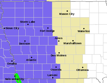
Winter Weather Advisory for counties shaded in purple.
* WHAT…Freezing drizzle expected. Total ice accumulations less than one tenth of an inch.
* WHERE…Mainly West of Interstate 35.
* WHEN…From 10 PM this evening to noon CST Friday.
* IMPACTS…Difficult travel conditions are possible. The hazardous conditions could impact the morning commute.
PRECAUTIONARY/PREPAREDNESS ACTIONS…
Slow down and use caution while traveling. Prepare for possible power outages. The latest road conditions for the state you are calling from can
be obtained by calling 5 1 1.
(Radio Iowa) — DEEP snow did not materialize in northwest Iowa, but the wind is whipping up the snow that did fall. National Weather Service meteorologist Brad Small says between two and five inches of snow fell north of a Storm Lake to Mason City line. “With these strong winds this morning, it’s produced areas of blowing snow. We have visibilities down to a mile or less across much of these same areas and that’ll continue through the morning hours as these winds don’t die down too much,” Small says. “We’re still looking at gusts of 40-50 miles per hour.”
The storm system that dumped a foot of snow in western Nebraska hit a wall of dry air when it reached Iowa according to Small.”That was some of the impact, what we call a dry slot in meteorology, where some dry area worked in,” Small says, “and that pushed probably the more significant snowfall totals to the north of us, into Minnesota.”
Rain fell in other parts of the state. “There was indeed some thunder,” Small says. “We had some thunder snow in the north and some thunder storms farther south and east, even some severe weather warnings were issued by the Quad Cities office along the Mississippi River, so we had all sorts of weather Tuesday night into Wednesday morning.”
Small is based in the National Weather Service office in Johnston.
The Audubon County Secondary Roads/Engineer’s Department reports Audubon county hard surface roads are completely to partially covered this morning. Strong winds are blowing snow and creating areas of reduced visibility. Plows headed out at 6am. They advise give yourself extra travel time this morning, and stay safe out there.
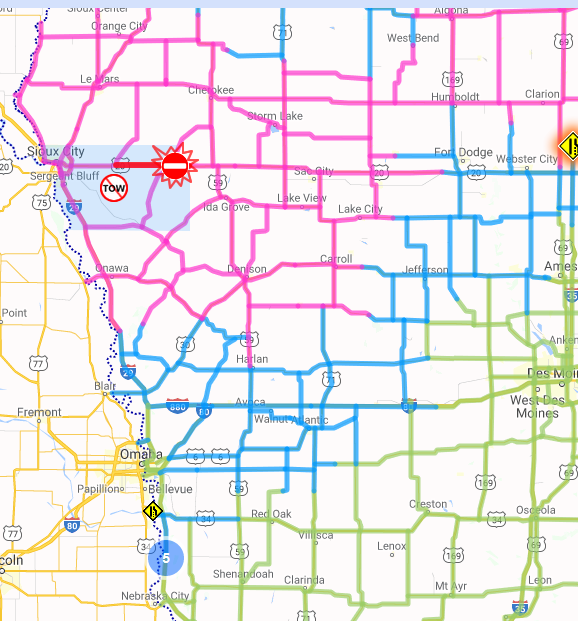
511ia.org road report (as of 5:07-a.m. today); Light blue – partially covered in snow/slush; Purple – Completely covered in snow w/icy bridges; Green – Normal driving conditions.


