
SEVERE THUNDERSTORM WATCH OUTLINE UPDATE FOR WS 301
NWS STORM PREDICTION CENTER NORMAN OK
1224 PM CDT MON JUN 16 2014
SEVERE THUNDERSTORM WATCH 301 REMAINS IN EFFECT UNTIL 200 PM CDT
FOR THE FOLLOWING LOCATIONS
. IOWA COUNTIES INCLUDED ARE
HARRISON LYON MONONA
PLYMOUTH POTTAWATTAMIE SHELBY
SIOUX WOODBURY
BULLETIN – IMMEDIATE BROADCAST REQUESTED
SEVERE THUNDERSTORM WARNING
NATIONAL WEATHER SERVICE OMAHA/VALLEY NEBRASKA
1142 AM CDT MON JUN 16 2014
THE NATIONAL WEATHER SERVICE IN OMAHA HAS ISSUED A
* SEVERE THUNDERSTORM WARNING FOR…
SOUTHWESTERN HARRISON COUNTY IN SOUTHWEST IOWA…
SOUTHEASTERN BURT COUNTY IN EAST CENTRAL NEBRASKA…
CENTRAL WASHINGTON COUNTY IN EAST CENTRAL NEBRASKA…
* UNTIL 1215 PM CDT
* AT 1142 AM CDT…A SEVERE THUNDERSTORM WAS LOCATED NEAR KENNARD…
OR 21 MILES NORTHWEST OF OMAHA…MOVING NORTHEAST AT 40 MPH.
HAZARD…QUARTER SIZE HAIL.
SOURCE…RADAR INDICATED.
IMPACT…DAMAGE TO VEHICLES IS EXPECTED.
* LOCATIONS IMPACTED INCLUDE…
BLAIR…MONDAMIN…KENNARD…MODALE AND HERMAN.
THIS INCLUDES THE FOLLOWING HIGHWAYS…
HIGHWAY 30 IN IOWA BETWEEN MILE MARKERS 1 AND 5.
HIGHWAY 30 IN NEBRASKA BETWEEN MILE MARKERS 438 AND 450.
HIGHWAY 75 IN NEBRASKA BETWEEN MILE MARKERS 111 AND 129.
INTERSTATE 29 BETWEEN MILE MARKERS 79 AND 92.
PRECAUTIONARY/PREPAREDNESS ACTIONS…
FOR YOUR PROTECTION MOVE TO AN INTERIOR ROOM ON THE LOWEST FLOOR OF A
BUILDING.
BULLETIN – IMMEDIATE BROADCAST REQUESTED
SEVERE THUNDERSTORM WARNING
NATIONAL WEATHER SERVICE OMAHA/VALLEY NEBRASKA
1134 AM CDT MON JUN 16 2014
THE NATIONAL WEATHER SERVICE IN OMAHA HAS ISSUED A
* SEVERE THUNDERSTORM WARNING FOR…
SOUTHWESTERN HARRISON COUNTY IN SOUTHWEST IOWA…
NORTHWESTERN POTTAWATTAMIE COUNTY IN SOUTHWEST IOWA…
EASTERN WASHINGTON COUNTY IN EAST CENTRAL NEBRASKA…
DOUGLAS COUNTY IN EAST CENTRAL NEBRASKA…
* UNTIL 1230 PM CDT
* AT 1134 AM CDT…A SEVERE THUNDERSTORM WAS LOCATED OVER ELKHORN…
OR 10 MILES WEST OF OMAHA…MOVING NORTHEAST AT 30 MPH.
HAZARD…GOLF BALL SIZE HAIL.
SOURCE…RADAR INDICATED.
IMPACT…PEOPLE AND ANIMALS OUTDOORS WILL BE INJURED. EXPECT
DAMAGE TO ROOFS…SIDING…WINDOWS AND VEHICLES.
* LOCATIONS IMPACTED INCLUDE…
WESTERN OMAHA…BLAIR…VALLEY…FORT CALHOUN…WATERLOO…
KENNARD…ELKHORN…MILLARD…BENNINGTON…BOYS TOWN…
WASHINGTON…DESOTO BEND NATIONAL WILDLIFE REFUGE AND WILSON ISLAND
STATE PARK.
THIS INCLUDES THE FOLLOWING HIGHWAYS…
HIGHWAY 275 IN NEBRASKA NEAR MILE MARKER 167.
HIGHWAY 30 IN IOWA BETWEEN MILE MARKERS 1 AND 5.
HIGHWAY 30 IN NEBRASKA BETWEEN MILE MARKERS 441 AND 450.
HIGHWAY 75 IN NEBRASKA BETWEEN MILE MARKERS 97 AND 117.
INTERSTATE 29 BETWEEN MILE MARKERS 66 AND 74.
PRECAUTIONARY/PREPAREDNESS ACTIONS…
THIS STORM IS PRODUCING LARGE HAIL. SEEK SHELTER NOW INSIDE A STURDY
STRUCTURE AND STAY AWAY FROM WINDOWS.
1121 AM CDT MON JUN 16 2014

THE NATIONAL WEATHER SERVICE IN OMAHA HAS ISSUED A

* SEVERE THUNDERSTORM WARNING FOR...
  NORTHWESTERN HARRISON COUNTY IN SOUTHWEST IOWA...
  MONONA COUNTY IN WEST CENTRAL IOWA...
  EASTERN BURT COUNTY IN EAST CENTRAL NEBRASKA...

* UNTIL 1215 PM CDT

* AT 1120 AM CDT...A SEVERE THUNDERSTORM WAS LOCATED OVER TEKAMAH...
  OR 37 MILES NORTH OF OMAHA...MOVING NORTHEAST AT 25 MPH.

  HAZARD...PING PONG BALL SIZE HAIL.

  SOURCE...RADAR INDICATED.

  IMPACT...PEOPLE AND ANIMALS OUTDOORS WILL BE INJURED. EXPECT
           DAMAGE TO ROOFS...SIDING...WINDOWS AND VEHICLES.

* LOCATIONS IMPACTED INCLUDE...
  ONAWA...TEKAMAH...WHITING...DECATUR...MONDAMIN...PISGAH...
  MOORHEAD...MAPLETON...BLENCOE...SOLDIER...LITTLE SIOUX...CASTANA...
  TURIN...PELICAN POINT STATE RECREATION AREA...LEWIS AND CLARK STATE
  PARK...KENNEBEC...PREPARATION CANYON STATE PARK AND LITTLE SIOUX
  SCOUT RANCH.

THIS INCLUDES THE FOLLOWING HIGHWAYS...
 HIGHWAY 75 IN NEBRASKA BETWEEN MILE MARKERS 129 AND 150.
 INTERSTATE 29 BETWEEN MILE MARKERS 89 AND 118.

PRECAUTIONARY/PREPAREDNESS ACTIONS...

FOR YOUR PROTECTION MOVE TO AN INTERIOR ROOM ON THE LOWEST FLOOR OF A
BUILDING.
The National Weather Service in Valley, NE has cancelled Severe Thunderstorm Watch # 301 for Fremont and Mills Counties in Southwest Iowa. The Watch remains in effect until 2-p.m. for Harrison, Pottawattamie and Monona Counties in the KJAN listening area.
The primary threat from storms that develop will be large hail with isolated damaging winds up to 70-miles per hour possible.
The latest weather statement from the National Weather Service points to an ever-increasing risk for severe thunderstorms across Iowa, today. Scattered thunderstorms may be moving northeast out of Nebraska into western Iowa and may contain large hail over an inch in diameter. More vigorous activity is expected to develop by mid to late afternoon over northwest Iowa then shift east into this evening.
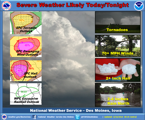
The latest outlook shows an increased risk for damaging winds and large hail.
Very strong storms are expected with this activity. Initial storms may produce very large hail and a few tornadoes before evolving into a damaging wind threat by mid to late evening. Heavy rainfall is possible as well, especially over northern Iowa. Localized flash flooding may occur with storms producing intense rainfall rates.
(Updated 9:45-a.m.)
SEVERE THUNDERSTORM WATCH OUTLINE UPDATE FOR WS 301 NWS STORM PREDICTION CENTER NORMAN OK 715 AM CDT MON JUN 16 2014
SEVERE THUNDERSTORM WATCH 301 IS IN EFFECT UNTIL 200 PM CDT FOR THE FOLLOWING LOCATIONS: IOWA COUNTIES INCLUDED ARE: FREMONT HARRISON LYON MILLS MONONA PLYMOUTH POTTAWATTAMIE SIOUX WOODBURY
THE NWS STORM PREDICTION CENTER HAS ISSUED A SEVERE THUNDERSTORM WATCH FOR PORTIONS OF
WESTERN IOWA
CENTRAL AND EASTERN NEBRASKA
SOUTHEAST SOUTH DAKOTA
* EFFECTIVE THIS MONDAY MORNING AND AFTERNOON FROM 715 AM UNTIL200 PM CDT.
* PRIMARY THREATS INCLUDE…
SCATTERED LARGE HAIL LIKELY WITH ISOLATED VERY LARGE HAIL EVENTS TO 2.5 INCHES IN DIAMETER POSSIBLE; ISOLATED DAMAGING WIND GUSTS TO 70 MPH POSSIBLE.
THE SEVERE THUNDERSTORM WATCH AREA IS APPROXIMATELY ALONG AND 95 STATUTE MILES EAST AND WEST OF A LINE FROM 20 MILES SOUTH SOUTHWEST OF BEATRICE NEBRASKA TO 10 MILES NORTH NORTHWEST OF MITCHELL SOUTH DAKOTA.
PRECAUTIONARY/PREPAREDNESS ACTIONS…
REMEMBER…A SEVERE THUNDERSTORM WATCH MEANS CONDITIONS ARE FAVORABLE FOR SEVERE THUNDERSTORMS IN AND CLOSE TO THE WATCH AREA. PERSONS IN THESE AREAS SHOULD BE ON THE LOOKOUT FOR THREATENING WEATHER CONDITIONS AND LISTEN FOR LATER STATEMENTS AND POSSIBLE WARNINGS. SEVERE THUNDERSTORMS CAN AND OCCASIONALLY DO PRODUCE TORNADOES.
The National Weather Service says severe thunderstorms are possible across Iowa, today. Scattered thunderstorms may develop this morning and may contain an attendant large hail threat up to the size of quarters. More vigorous activity is expected to develop by mid to late afternoon over northwest Iowa then shift east into this evening.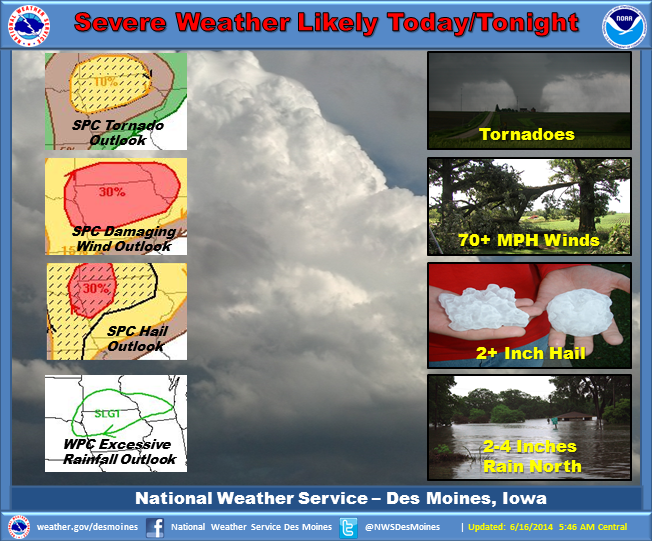
Very strong storms are expected with this activity. Initial storms may produce very large hail and a few tornadoes before evolving into a damaging wind threat by mid to late evening. Heavy rainfall is possible as well, especially over northern Iowa. Localized flash flooding may occur with storms producing intense rainfall rates.
The Freese-Notis (podcast) weather forecast for the KJAN listening area, and weather information for Atlantic.
Podcast: Play in new window | Download (1,001.3KB)
Subscribe: RSS
COUNTIES: MONONA-HARRISON-SHELBY-POTTAWATTAMIE-MILLS-MONTGOMERY-FREMONT-
PAGE-
501 AM CDT MON JUN 16 2014
TODAY AND TONIGHT:
THERE WILL BE A CHANCE OF THUNDERSTORMS ACROSS THE REGION TODAY THROUGH THIS EVENING. A FEW STORMS COULD CONTAIN SMALL HAIL IN NORTHEAST NEBRASKA THIS MORNING. THEN…SEVERE STORMS WILL BE POSSIBLE THIS AFTERNOON AS VERY HIGH INSTABILITY DEVELOPS AS DEEPER MOISTURE RETURNS TO THE REGION AND A WARM FRONT LIFTS NORTHWARD ACROSS THE PLAINS. VERY LARGE HAIL AND DAMAGING WINDS WILL BE POSSIBLE WITH ANY SUPERCELLS THAT DEVELOP LATER TODAY. AND ISOLATED TORNADO WILL ALSO BE POSSIBLE BETWEEN OMAHA AND SIOUX CITY. THUNDERSTORMS SHOULD PUSH EAST OF THE AREA BY MIDNIGHT.
TUESDAY AND WEDNESDAY: HOT AND HUMID CONDITIONS ARE EXPECTED FOR TUESDAY AND WEDNESDAY. AFTERNOON HEAT INDEX VALUES COULD APPROACH 95 TO 100 BOTH DAYS.


