
SAC-CALHOUN-WEBSTER-CRAWFORD-CARROLL-GREENE-BOONE-AUDUBON-GUTHRIE-
DALLAS-CASS-ADAIR-MADISON-ADAMS-UNION-TAYLOR-RINGGOLD-
SAT JUN 14 2014
TONIGHT: THERE IS A MODERATE RISK FOR SEVERE WEATHER THROUGH TONIGHT. THE GREATEST POTENTIAL WILL BE FROM 9 PM TO 4 AM. DAMAGING WIND GUSTS IN EXCESS OF 70 MPH IS THE PRIMARY THREAT HOWEVER GOLF BALL SIZED HAIL AND ISOLATED TORNADOES MAY OCCUR. AN AREA OF HEAVY RAINFALL IS POSSIBLE TONIGHT. RAINFALL AMOUNTS EXCEEDING 3 INCHES MAY OCCUR.
232 PM CDT SAT JUN 14 2014
LATE THIS AFTERNOON…MOSTLY CLOUDY. WINDY. SOUTH WIND 25 TO 30 MPH WITH GUSTS TO AROUND 45 MPH.
TONIGHT…MOSTLY CLOUDY. BREEZY. ISOLATED THUNDERSTORMS IN THE EVENING…THEN SCATTERED THUNDERSTORMS BEFORE MIDNIGHT AND EARLY MORNING. NUMEROUS THUNDERSTORMS EARLY IN THE MORNING. SOME THUNDERSTORMS MAY BE SEVERE WITH DAMAGING WIND OVERNIGHT. LOW IN THE MID 60S. SOUTH WIND 20 TO 25 MPH. GUSTS UP TO 40 MPH DECREASING TO 30 MPH AFTER MIDNIGHT. CHANCE OF THUNDERSTORMS 70 PERCENT.
SUNDAY…MOSTLY CLOUDY WITH A CHANCE OF THUNDERSTORMS THROUGH MID MORNING…THEN PARTLY SUNNY WITH A SLIGHT CHANCE OF THUNDERSTORMS BEFORE NOON. SUNNY IN THE AFTERNOON. SOME THUNDERSTORMS MAY PRODUCE HEAVY RAINFALL THROUGH MID MORNING. HIGH IN THE LOWER 80S. WEST WIND 10 TO 15 MPH. GUSTS UP TO 25 MPH IN THE MORNING. CHANCE OF THUNDERSTORMS 40 PERCENT.
SUNDAY NIGHT…MOSTLY CLEAR. LOW IN THE LOWER 60S. SOUTH WIND 5 TO 10 MPH.
MONDAY…MOSTLY SUNNY. A 40 PERCENT CHANCE OF THUNDERSTORMS IN THE AFTERNOON. BREEZY. HIGH IN THE MID 80S. SOUTH WIND 5 TO 15 MPH INCREASING TO 15 TO 20 MPH WITH GUSTS TO AROUND 30 MPH IN THE AFTERNOON.
MONDAY NIGHT…MOSTLY CLOUDY WITH A 50 PERCENT CHANCE OF THUNDERSTORMS. BREEZY. LOW AROUND 70. SOUTH WIND 10 TO 20 MPH WITH GUSTS TO AROUND 30 MPH.
The National Weather Service in its mid-morning weather briefing, Saturday, said severe weather is still in the forecast for tonight across portions of Iowa. The primary threat in western Iowa appears to be from damaging winds in excess of 58-miles per hour. However, large hail and isolated tornadoes are also possible.The area is under a “Moderate risk” for severe weather.
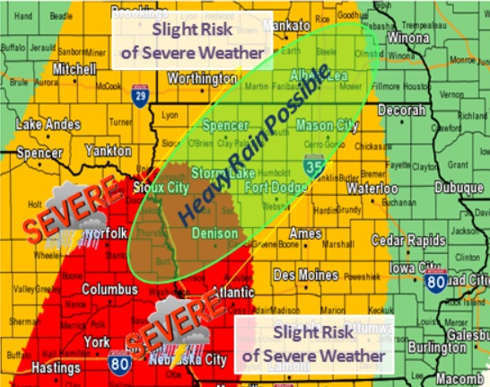
Areas in red are under a “Moderate” risk of severe weather tonight, areas in yellow will experience a “Slight” risk for severe weather. (NWS graphic)
Keep in mind, that winds of 60-to 80-miles per hour can have the same effect as an EF-1 tornado, and tree debris may be difficult to see on the road at night.
If you are camping or have plans to do so, make sure you have a way to receive weather information and a safe place for emergency shelter, and if at home, keep your weather radio ready to go with fresh batteries.
POTTAWATTAMIE-MILLS-MONTGOMERY-FREMONT-PAGE

...WIND ADVISORY IN EFFECT FROM 11 AM THIS MORNING TO 5 PM CDT
THIS AFTERNOON...

THE NATIONAL WEATHER SERVICE IN OMAHA/VALLEY HAS ISSUED A WIND
ADVISORY...WHICH IS IN EFFECT FROM 11 AM THIS MORNING TO 5 PM CDT
THIS AFTERNOON.

* WINDS...SOUTHERLY WINDS WILL INCREASE TO AROUND 25 TO 30 MPH
  TODAY WITH GUSTS UP TO 40 TO 45 MPH AT TIMES.

* IMPACTS...BE SURE TO SECURE LOOSE ITEMS AROUND YOUR HOME OR
  BUSINESS. HIGH PROFILE VEHICLES MAY HAVE A DIFFICULT TIME
  DRIVING IN THE HIGH WIND.

PRECAUTIONARY/PREPAREDNESS ACTIONS...

A WIND ADVISORY MEANS THAT WINDS OF 30 MPH OR GREATER ARE EXPECTED.
WINDS THIS STRONG CAN MAKE DRIVING DIFFICULT...ESPECIALLY FOR HIGH
PROFILE VEHICLES. USE EXTRA CAUTION.
Today: Scattered showers and thunderstorms, mainly after 5pm. Partly sunny, with a high near 81. Windy, with a south wind 15 to 20 mph increasing to 20 to 25 mph in the afternoon. Winds could gust as high as 35 mph. Chance of precipitation is 30%. New rainfall amounts of less than a tenth of an inch, except higher amounts possible in thunderstorms.
Tonight: Showers and thunderstorms. Some storms could be severe, with heavy rain. Low around 66. Windy, with a south wind 20 to 25 mph, with gusts as high as 30 mph. Chance of precipitation is 90%. New rainfall amounts between three quarters and one inch possible.
Sunday: A slight chance of showers and thunderstorms, mainly before 7am. Mostly cloudy, then gradually becoming sunny, with a high near 81. Southwest wind 10 to 15 mph becoming west northwest in the afternoon. Winds could gust as high as 20 mph.
Sunday Night: Mostly clear, with a low around 61. West southwest wind 5 to 10 mph becoming south after midnight.
Monday: A moderate chance of showers and thunderstorms after 1pm. Mostly sunny, with a high near 86. Breezy, with a south wind 5 to 15 mph increasing to 15 to 20 mph in the afternoon. Winds could gust as high as 30 mph.
Tuesday: A slight chance of showers and thunderstorms. Mostly sunny, with a high near 88. Breezy.
Podcast: Play in new window | Download (595.9KB)
Subscribe: RSS
The National Weather Service in Valley, NE., says severe storms are possible Saturday night through early Sunday morning across a large portion of east central Nebraska and parts of western Iowa. In the KJAN listening area, parts of Crawford, Monona, Harrison, Shelby and Pottawattamie Counties will be under the gun for the most severe weather this weekend.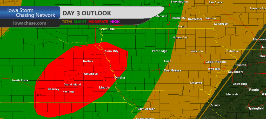
In their Hazardous Weather Outlook issued this (Friday) morning, the Weather Service says very large hail, damaging winds and heavy rainfall can be expected, with some areas along and north of Interstate 80 picking up in excess of two-inches of rain.
An isolated tornado cannot be ruled out, either Saturday evening. The Storm Prediction Center in Norman, OK., has indicated that a “Moderate Risk” of severe storms will exist across most of the area. Storm spotters will likely be called into action Saturday afternoon and night.
The Freese-Notis weather forecast for the KJAN listening area, and weather information for Atlantic from KJAN News Director Ric Hanson.
Podcast: Play in new window | Download (980.2KB)
Subscribe: RSS
331 AM CDT FRI JUN 13 2014
EARLY THIS MORNING…CLEAR…COOLER. NORTH WIND NEAR 5 MPH.
TODAY...SUNNY. HIGH IN THE MID 70S. EAST WIND NEAR 5 MPH SHIFTING TO THE SOUTH IN THE AFTERNOON.
TONIGHT…MOSTLY CLEAR. WARMER. LOW IN THE UPPER 50S. SOUTH WIND 10 TO 15 MPH.
SATURDAY…PARTLY SUNNY. A SLIGHT CHANCE OF THUNDERSTORMS BEFORE NOON. A CHANCE OF THUNDERSTORMS IN THE AFTERNOON. BREEZY. HIGH IN THE LOWER 80S. SOUTH WIND 15 TO 25 MPH WITH GUSTS TO AROUND 35 MPH. CHANCE OF THUNDERSTORMS 40 PERCENT.
SATURDAY NIGHT…THUNDERSTORMS LIKELY THROUGH MIDNIGHT…THEN THUNDERSTORMS AFTER MIDNIGHT. BREEZY. SOME THUNDERSTORMS MAY BE SEVERE WITH HEAVY RAINFALL THROUGH MIDNIGHT. LOW IN THE UPPER 60S. SOUTH WIND 15 TO 20 MPH WITH GUSTS TO AROUND 30 MPH. CHANCE OF THUNDERSTORMS 80 PERCENT.
SUNDAY…MOSTLY SUNNY. A CHANCE OF THUNDERSTORMS IN THE MORNING…THEN A SLIGHT CHANCE OF THUNDERSTORMS IN THE AFTERNOON. HIGH IN THE LOWER 80S. WEST WIND 10 TO 15 MPH. CHANCE OF THUNDERSTORMS 50 PERCENT.
SUNDAY NIGHT…MOSTLY CLEAR. LOW IN THE LOWER 60S.
MONDAY…PARTLY SUNNY WITH A 30 PERCENT CHANCE OF THUNDERSTORMS. HIGH IN THE MID 80S.
DES MOINES, Iowa (AP) – Storms last week brought with them some peril in the form of wind and large hail but they also delivered enough rain to significantly relieve drought conditions in Iowa and Nebraska. The latest U.S. Drought Monitor report released Thursday shows Iowa’s remaining drought is mostly confined to the northwest and southeast corners of the state. About 40 percent of the state has some drought down from nearly 56 percent a week earlier.
In Nebraska, the drought area has been reduced to 63 percent of the state from nearly 70 percent the week before. Extreme drought was removed from central Nebraska. About 30 percent of the 50 U.S. states and Puerto Rico have moderate drought or worse, compared with 31 percent a week earlier.
The Freese-Notis weather forecast for the KJAN listening area, and weather information for Atlantic from KJAN News Director Ric Hanson.
Podcast: Play in new window | Download (1.0MB)
Subscribe: RSS


