
The National Weather Service says severe thunderstorms are possible across Iowa, today. Scattered thunderstorms may develop this morning and may contain an attendant large hail threat up to the size of quarters. More vigorous activity is expected to develop by mid to late afternoon over northwest Iowa then shift east into this evening.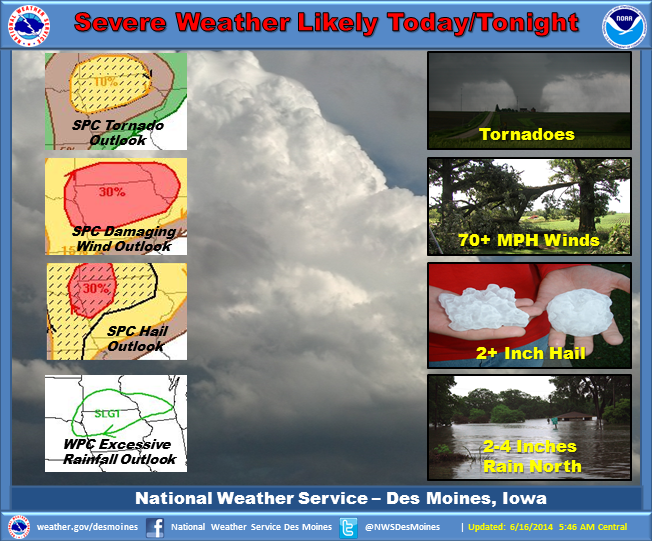
Very strong storms are expected with this activity. Initial storms may produce very large hail and a few tornadoes before evolving into a damaging wind threat by mid to late evening. Heavy rainfall is possible as well, especially over northern Iowa. Localized flash flooding may occur with storms producing intense rainfall rates.
The Freese-Notis (podcast) weather forecast for the KJAN listening area, and weather information for Atlantic.
Podcast: Play in new window | Download (1,001.3KB)
Subscribe: RSS
COUNTIES: MONONA-HARRISON-SHELBY-POTTAWATTAMIE-MILLS-MONTGOMERY-FREMONT-
PAGE-
501 AM CDT MON JUN 16 2014
TODAY AND TONIGHT:
THERE WILL BE A CHANCE OF THUNDERSTORMS ACROSS THE REGION TODAY THROUGH THIS EVENING. A FEW STORMS COULD CONTAIN SMALL HAIL IN NORTHEAST NEBRASKA THIS MORNING. THEN…SEVERE STORMS WILL BE POSSIBLE THIS AFTERNOON AS VERY HIGH INSTABILITY DEVELOPS AS DEEPER MOISTURE RETURNS TO THE REGION AND A WARM FRONT LIFTS NORTHWARD ACROSS THE PLAINS. VERY LARGE HAIL AND DAMAGING WINDS WILL BE POSSIBLE WITH ANY SUPERCELLS THAT DEVELOP LATER TODAY. AND ISOLATED TORNADO WILL ALSO BE POSSIBLE BETWEEN OMAHA AND SIOUX CITY. THUNDERSTORMS SHOULD PUSH EAST OF THE AREA BY MIDNIGHT.
TUESDAY AND WEDNESDAY: HOT AND HUMID CONDITIONS ARE EXPECTED FOR TUESDAY AND WEDNESDAY. AFTERNOON HEAT INDEX VALUES COULD APPROACH 95 TO 100 BOTH DAYS.
Today A 40 percent chance of showers and thunderstorms, mainly after 1pm. Some of the storms could produce heavy rain. Mostly sunny, with a high near 88. Windy, with a south southeast wind 7 to 12 mph increasing to 19 to 24 mph in the afternoon. Winds could gust as high as 32 mph. New rainfall amounts of less than a tenth of an inch, except higher amounts possible in thunderstorms.
Tonight A 50 percent chance of showers and thunderstorms, mainly before 1am. Some of the storms could produce heavy rain. Mostly cloudy, with a low around 72. Breezy, with a south wind 15 to 18 mph, with gusts as high as 26 mph. New rainfall amounts between a tenth and quarter of an inch, except higher amounts possible in thunderstorms.
Tuesday Mostly sunny, with a high near 93. Heat index values as high as 102. Windy, with a south wind 15 to 21 mph, with gusts as high as 29 mph.
Tuesday Night Partly cloudy, with a low around 74. Breezy, with a south wind 11 to 18 mph, with gusts as high as 26 mph.
Wednesday Mostly sunny, with a high near 89. Breezy, with a south wind 13 to 17 mph, with gusts as high as 25 mph.
Wednesday Night Showers and thunderstorms likely. Mostly cloudy, with a low around 70. Chance of precipitation is 60%. New rainfall amounts between a half and three quarters of an inch possible.
Thursday A 40 percent chance of showers and thunderstorms. Partly sunny, with a high near 82.
Sunday, June 15th 2014 – Father’s Day
Today: Scattered showers and thunderstorms before 9am. Cloudy through mid morning, then gradual clearing, with a high near 82. Breezy, with a south southwest wind 10 to 16 mph becoming west northwest in the afternoon. Winds could gust as high as 23 mph. Chance of precipitation is 30%. New rainfall amounts of less than a tenth of an inch, except higher amounts possible in thunderstorms.
Tonight: Mostly clear, with a low around 61. West wind 5 to 8 mph becoming south southeast after midnight.
Monday: A 40 percent chance of showers and thunderstorms, mainly after 10am. Mostly sunny, with a high near 86. Windy, with a south southeast wind 7 to 12 mph increasing to 18 to 23 mph in the afternoon. Winds could gust as high as 31 mph. New rainfall amounts of less than a tenth of an inch, except higher amounts possible in thunderstorms.
Monday Night: A 50 percent chance of showers and thunderstorms. Mostly cloudy, with a low around 72. Windy, with a south wind 16 to 22 mph, with gusts as high as 30 mph. New rainfall amounts between a quarter and half of an inch possible.
Tuesday: Mostly sunny, with a high near 92. Windy, with a south southwest wind 16 to 21 mph, with gusts as high as 29 mph.
Tuesday Night: Partly cloudy, with a low around 74. Breezy.
Wednesday: A 20 percent chance of showers and thunderstorms. Partly sunny, with a high near 88. Breezy.
*******
Saturday’s High in Atlantic was 81. Our low through 6-a.m. today was 61. Rainfall in Atlantic overnight through 6-a.m. today (Sunday), was .4″ (four-tenths of an inch).
542 AM CDT SUN JUN 15 2014 NWS Des Moines
TODAY AND TONIGHT: A FEW NON SEVERE THUNDERSTORMS ARE POSSIBLE TODAY.
MONDAY THROUGH FRIDAY….
ANOTHER ROUND OF STRONG TO SEVERE THUNDERSTORMS IS FORECAST FOR MONDAY AND MONDAY NIGHT. A FEW OF THESE STORMS MAY BECOME VERY STRONG WITH VERY LARGE HAIL…DAMAGING WINDS AND A FEW TORNADOES POSSIBLE. VERY HEAVY RAINFALL WILL BE POSSIBLE WITH THESE STORMS AS WELL.
ADDITIONAL ROUNDS OF THUNDERSTORMS ARE POSSIBLE THROUGH THE REMAINDER OF THE PERIOD WITH THE HIGHEST CHANCES THURSDAY AND FRIDAY. LOCALLY HEAVY RAIN AND A FEW SEVERE THUNDERSTORMS WILL BE POSSIBLE THROUGH THE PERIOD.
SPOTTER INFORMATION STATEMENT…
SPOTTER ACTIVATION IS LIKELY MONDAY AFTERNOON AND EVENING.
THE NATIONAL WEATHER SERVICE HAS CANCELLED SEVERE THUNDERSTORM WATCH 298 FOR THE FOLLOWING AREAS: IN SOUTHWEST IOWA THIS APPLIES TO ADAIR ADAMS CASS AND TAYLOR COUNTIES, AND IN WEST CENTRAL IOWA, AUDUBON CALHOUN CARROLL CRAWFORD GREENE GUTHRIE AND SAC COUNTIES.
346 AM CDT SUN JUN 15 2014
SEVERE THUNDERSTORM WATCH 298 IN EFFECT UNTIL 5 AM CDT…
EARLY THIS MORNING…PERIODS OF THUNDERSTORMS. BREEZY. SOME THUNDERSTORMS MAY PRODUCE HEAVY RAINFALL. SOUTH WIND 15 TO 20 MPH WITH GUSTS TO AROUND 30 MPH. CHANCE OF THUNDERSTORMS NEAR 100 PERCENT.
TODAY…CLOUDY WITH THUNDERSTORMS LIKELY THROUGH MID MORNING…THEN MOSTLY SUNNY WITH ISOLATED THUNDERSTORMS BEFORE NOON. SUNNY IN THE AFTERNOON. BREEZY. HIGH IN THE LOWER 80S. WEST WIND 10 TO 20 MPH. CHANCE OF THUNDERSTORMS 70 PERCENT.
TONIGHT...MOSTLY CLEAR. LOW IN THE LOWER 60S. SOUTHWEST WIND 5 TO 10 MPH SHIFTING TO THE SOUTH AFTER MIDNIGHT.
MONDAY…MOSTLY SUNNY. A SLIGHT CHANCE OF THUNDERSTORMS IN THE MORNING…THEN A CHANCE OF THUNDERSTORMS IN THE AFTERNOON. BREEZY. HIGH IN THE MID 80S. SOUTH WIND 5 TO 15 MPH INCREASING TO 15 TO 25 MPH IN THE AFTERNOON. CHANCE OF THUNDERSTORMS 40 PERCENT.
MONDAY NIGHT…MOSTLY CLOUDY WITH A 50 PERCENT CHANCE OF THUNDERSTORMS. BREEZY. LOW IN THE LOWER 70S. SOUTH WIND 15 TO 25 MPH.
TUESDAY…MOSTLY SUNNY. BREEZY. HIGH IN THE LOWER 90S. SOUTH WIND 15 TO 20 MPH WITH GUSTS TO AROUND 30 MPH. HIGHEST HEAT INDEX READINGS AROUND 100 IN THE AFTERNOON.
WEDNESDAY…PARTLY SUNNY WITH A 20 PERCENT CHANCE OF THUNDERSTORMS. HIGH IN THE UPPER 80S.
343 AM CDT SUN JUN 15 2014
SEVERE THUNDERSTORM WATCH 298 REMAINS IN EFFECT UNTIL 500 AM CDT FOR THE FOLLOWING LOCATIONS…IOWA COUNTIES INCLUDED ARE:
ADAIR ADAMS AUDUBON BUENA VISTA CALHOUN CARROLL CASS CHEROKEE CRAWFORD GREENE GUTHRIE IDA PLYMOUTH POCAHONTAS SAC TAYLOR WOODBURY
NWS STORM PREDICTION CENTER NORMAN OK
1150 PM CDT SAT JUN 14 2014
SEVERE THUNDERSTORM WATCH 298 IS IN EFFECT UNTIL 500 AM CDT FOR THE FOLLOWING LOCATIONS…
. IOWA COUNTIES INCLUDED ARE ADAIR ADAMS AUDUBON BUENA VISTA CALHOUN CARROLL CASS CHEROKEE CRAWFORD FREMONT GREENE GUTHRIE HARRISON IDA MILLS MONONA MONTGOMERY PAGE PLYMOUTH POCAHONTAS POTTAWATTAMIE SAC SHELBY TAYLOR WOODBURY.


