
756 AM CDT THU JUN 19 2014: THE SEVERE THUNDERSTORM WARNING FOR NORTHEASTERN AUDUBON COUNTY IS CANCELLED…THE SEVERE THUNDERSTORM WHICH PROMPTED THE WARNING HAS MOVED OUT OF THE WARNED AREA. THEREFORE THE WARNING HAS BEEN CANCELLED.
A SEVERE THUNDERSTORM WARNING REMAINS IN EFFECT UNTIL 815 AM CDT FOR SOUTHEASTERN CARROLL…NORTHWESTERN GUTHRIE AND SOUTHWESTERN GREENE COUNTIES…AT 755 AM CDT…A SEVERE THUNDERSTORM WAS LOCATED NEAR COON RAPIDS…OR 13 MILES NORTHWEST OF GUTHRIE CENTER…MOVING NORTHEAST AT 35 MPH.
HAZARD…QUARTER SIZE HAIL.
Severe weather is possible across much of Iowa once again today. Already this morning, a Severe Thunderstorm Warning was issued for parts of Carroll, Audubon, Guthrie and Greene Counties, with nickel-sized hail having been reported just east of Audubon at around 7:35-a.m.
The Storm Prediction Center in Norman, OK., has placed much of Iowa in a slight risk for severe storms. In addition to damaging winds and large hail, heavy rainfall is possible. An additional widespread 1″ to 1.5″ may fall over already rain-soaked locations… including those in the Flash Flood Watch.
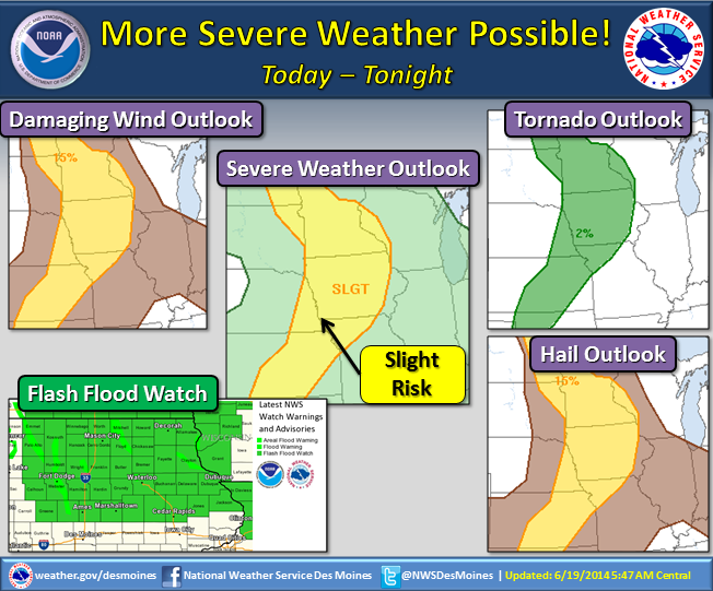
Flash Flood Watch (green shaded counties- lower left image).
The slight risk area may shift throughout the daytime, so please make sure you stay up to date with the latest weather forecast information…especially if you have travel and/or outdoor plans today!
BULLETIN – IMMEDIATE BROADCAST REQUESTED
SEVERE THUNDERSTORM WARNING
NATIONAL WEATHER SERVICE DES MOINES IA
738 AM CDT THU JUN 19 2014
THE NATIONAL WEATHER SERVICE IN DES MOINES HAS ISSUED A
* SEVERE THUNDERSTORM WARNING FOR…
SOUTHEASTERN CARROLL COUNTY IN WEST CENTRAL IOWA…
NORTHEASTERN AUDUBON COUNTY IN WEST CENTRAL IOWA…
NORTHWESTERN GUTHRIE COUNTY IN WEST CENTRAL IOWA…
SOUTHWESTERN GREENE COUNTY IN WEST CENTRAL IOWA…
* UNTIL 815 AM CDT
* AT 738 AM CDT…A SEVERE THUNDERSTORM WAS LOCATED 8 MILES EAST OF
AUDUBON…MOVING NORTHEAST AT 35 MPH.
HAZARD…QUARTER SIZE HAIL.
SOURCE…RADAR INDICATED. A SPOTTER EAST OF AUDUBON REPORTED
NICKEL SIZE HAIL WITH THE STORM.
IMPACT…DAMAGE TO VEHICLES IS EXPECTED.
* LOCATIONS IMPACTED INCLUDE…
COON RAPIDS…SCRANTON…BAYARD AND RALSTON.
PRECAUTIONARY/PREPAREDNESS ACTIONS…
FOR YOUR PROTECTION MOVE TO AN INTERIOR ROOM ON THE LOWEST FLOOR OF A
BUILDING.
The Freese-Notis weather forecast for Atlantic & the KJAN listening area, and weather information for Atlantic.
Podcast: Play in new window | Download (1.0MB)
Subscribe: RSS
Today – Showers and thunderstorms, mainly after 2pm. High near 85. South southwest wind 8 to 13 mph. Chance of precipitation is 80%. New rainfall amounts between a half and three quarters of an inch possible.
Tonight – Showers and thunderstorms, mainly before 1am. Low around 66. West southwest wind 3 to 8 mph. Chance of precipitation is 80%. New rainfall amounts between a quarter and half of an inch possible.
Friday – Mostly sunny, with a high near 89. Southwest wind 3 to 7 mph.
Friday Night – Partly cloudy, with a low around 68. South southwest wind 5 to 8 mph.
Saturday – A 20 percent chance of showers and thunderstorms. Mostly sunny, with a high near 88. South southwest wind 6 to 8 mph.
Saturday Night – A 30 percent chance of showers and thunderstorms. Mostly cloudy, with a low around 67. New rainfall amounts of less than a tenth of an inch, except higher amounts possible in thunderstorms.
Sunday – A 40 percent chance of showers and thunderstorms. Partly sunny, with a high near 84.
The Freese-Notis (podcast) weather forecast for the KJAN listening area, and weather information for Atlantic.
Podcast: Play in new window | Download (1.0MB)
Subscribe: RSS
Today Isolated showers and thunderstorms after 3pm. Mostly sunny, with a high near 92. Heat index values as high as 101. Breezy, with a south wind 15 to 18 mph, with gusts as high as 26 mph. Chance of precipitation is 20%.
Tonight A 50 percent chance of showers and thunderstorms, mainly after 9pm. Increasing clouds, with a low around 72. South wind 10 to 15 mph, with gusts as high as 21 mph. New rainfall amounts between a quarter and half of an inch possible.
Thursday Showers and thunderstorms likely, mainly after 1pm. Mostly cloudy, with a high near 87. South southwest wind 8 to 13 mph. Chance of precipitation is 70%. New rainfall amounts between a half and three quarters of an inch possible.
Thursday Night A 20 percent chance of showers and thunderstorms. Partly cloudy, with a low around 66. Southwest wind 5 to 7 mph becoming calm after midnight.
Friday Mostly sunny, with a high near 90. Calm wind becoming south southwest 5 to 8 mph in the morning.
Friday Night A 40 percent chance of showers and thunderstorms. Mostly cloudy, with a low around 69. New rainfall amounts between a tenth and quarter of an inch, except higher amounts possible in thunderstorms.
Saturday A 40 percent chance of showers and thunderstorms. Mostly sunny, with a high near 86.
KJAN Studios- .42″
Massena (Ardell McCunn)- .32″
N. of Atlantic (Lavon Eblen)- 1″
(Update as of 3:40-a.m. from the NWS in Des Moines)
EARLY THIS MORNING…WIDESPREAD THUNDERSTORMS. SOME THUNDERSTORMS MAY PRODUCE DAMAGING WIND…LARGE HAIL AND HEAVY RAINFALL. EAST WIND 10 TO 15 MPH WITH GUSTS TO AROUND 30 MPH. CHANCE OF THUNDERSTORMS NEAR 100 PERCENT.
TODAY…MOSTLY SUNNY. HOT AND HUMID. ISOLATED THUNDERSTORMS THROUGH MID MORNING. BREEZY. HIGH IN THE LOWER 90S. SOUTH WIND 15 TO 20 MPH WITH GUSTS TO AROUND 30 MPH. CHANCE OF THUNDERSTORMS 20 PERCENT. HIGHEST HEAT INDEX READINGS AROUND 100 IN THE AFTERNOON.
TONIGHT…PARTLY CLOUDY. WARMER. LOW IN THE MID 70S. SOUTH WIND 10 TO 15 MPH. GUSTS UP TO 30 MPH THROUGH MIDNIGHT. HIGHEST HEAT INDEX READINGS AROUND 100 THROUGH MIDNIGHT.
WEDNESDAY…MOSTLY SUNNY. HOT AND HUMID. BREEZY. HIGH IN THE LOWER 90S. SOUTH WIND 10 TO 20 MPH WITH GUSTS TO AROUND 30 MPH. HIGHEST HEAT INDEX READINGS AROUND 100 IN THE AFTERNOON.
THURSDAY…THUNDERSTORMS LIKELY. HIGH 85 TO 91. SOUTH WIND 10 TO 15 MPH WITH GUSTS TO AROUND 25 MPH. CHANCE OF THUNDERSTORMS 60 PERCENT. HEAT INDEX READINGS AROUND 100.
FRIDAY…MOSTLY SUNNY WITH A 20 PERCENT CHANCE OF THUNDERSTORMS. HIGH IN THE MID 80S.
THE NATIONAL WEATHER SERVICE HAS CANCELLED THE FLASH FLOOD WATCH FOR PORTIONS OF CENTRAL IOWA…SOUTH CENTRAL IOWA…SOUTHWEST IOWA AND WEST CENTRAL IOWA. WHILE RAIN WILL CONTINUE FOR A FEW HOURS, OFFICIALS SAY THE THREAT FOR HEAVY RAINFALL HAS ENDED.
AS OF 3:30-A.M., THERE WERE NO WATCHES OR WARNINGS IN EFFECT FOR WESTERN AND SOUTHWEST IOWA.


