
Today: A 40 percent chance of showers and thunderstorms, mainly after 3pm. Partly sunny, with a high near 91. Heat index values as high as 101. Breezy, with a south wind 13 to 17 mph, with gusts as high as 23 mph. New rainfall amounts between a quarter and half of an inch possible.
**Flash Flood Watch in effect from 7-p.m. Sunday until 10-a.m. Monday**
Tonight: Showers and thunderstorms. Some of the storms could produce heavy rain. Low around 69. South wind 5 to 8 mph becoming light and variable in the evening. Chance of precipitation is 90%. New rainfall amounts between 1 and 2 inches possible.
Labor Day: A 50 percent chance of showers and thunderstorms. Mostly cloudy, with a high near 81. Light and variable wind becoming east northeast 5 to 8 mph in the morning. New rainfall amounts between a half and three quarters of an inch possible.
Monday Night: Showers and thunderstorms. Some of the storms could produce heavy rain. Low around 66. East southeast wind 3 to 7 mph. Chance of precipitation is 80%. New rainfall amounts between 1 and 2 inches possible.
Tuesday: Showers and thunderstorms likely. Mostly cloudy, with a high near 78. East northeast wind 3 to 8 mph. Chance of precipitation is 60%. New rainfall amounts between a quarter and half of an inch possible.
Tuesday Night: A 20 percent chance of showers and thunderstorms. Partly cloudy, with a low around 57.
Wednesday: Sunny, with a high near 77.
AREA COUNTIES: AUDUBON; GUTHRIE; DALLAS; CASS; ADAIR; MADISON; ADAMS; UNION; TAYLOR AND RINGGOLD.
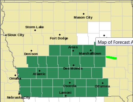
Counties in green are included in a Flash Flood Watch.
THE NATIONAL WEATHER SERVICE IN DES MOINES HAS ISSUED A FLASH FLOOD WATCH FROM THIS EVENING THROUGH MONDAY MORNING. NUMEROUS THUNDERSTORMS PRODUCING WIDESPREAD 1 TO 3 INCHES OF RAINFALL ARE EXPECTED WITH LOCALLY HIGHER AMOUNTS IN EXCESS OF 5 INCHES POSSIBLE.
THE HEAVY RAINFALL MAY LEAD TO FLASH FLOODING DUE TO RAPID RISES ALONG SMALL STREAMS AND CREEKS. IN ADDITION…SIGNIFICANT PONDING OF WATER MAY OCCUR.
PRECAUTIONARY/PREPAREDNESS ACTIONS…
A FLASH FLOOD WATCH MEANS THAT CONDITIONS MAY DEVELOP THAT LEAD TO FLASH FLOODING. FLASH FLOODING IS A VERY DANGEROUS SITUATION. YOU SHOULD MONITOR LATER FORECASTS AND BE PREPARED TO TAKE ACTION SHOULD FLASH FLOOD WARNINGS BE ISSUED.
424 AM CDT SUN SEP 6 2015
A FLASH FLOOD WATCH IS IN EFFECT FROM THIS EVENING THROUGH MONDAY MORNING FOR THE FOLLOWING COUNTIES: FREMONT; MILLS; MONTGOMERY; PAGE; POTTAWATTAMIE AND SHELBY.
HEAVY RAINFALL IS POSSIBLE IN SOUTHWEST IOWA TONIGHT. THUNDERSTORMS ARE FORECAST TO DEVELOP LATE THIS AFTERNOON AND CONTINUE OVERNIGHT AS A COLD FRONT MOVES INTO THE AREA. THAT FRONT IS EXPECTED TO STALL IN SOUTHWEST IOWA…PROVIDING A FOCUS FOR CONTINUED DEVELOPMENT OVERNIGHT.
Counties in green are included in a Flash Flood Watch.
CONTINUED THUNDERSTORM DEVELOPMENT ALONG A STALLING COLD FRONT WILL LEAD TO SLOW-MOVING STORMS THAT COULD DROP RAINFALL AMOUNTS WELL OVER 2 INCHES IN A RELATIVELY SHORT PERIOD OF TIME. LOCAL RAIN AMOUNTS COULD EXCEED 4 INCHES. THE HEAVY RAINFALL COULD LEAD TO FLASH FLOODING OF ROADWAYS AND LOW WATER CROSSINGS. RAPID RISES IN SMALL CREEKS AND STREAMS COULD ALSO OCCUR.
PRECAUTIONARY/PREPAREDNESS ACTIONS…
A FLASH FLOOD WATCH MEANS THAT CONDITIONS MAY DEVELOP THAT LEAD TO FLASH FLOODING. FLASH FLOODING IS A VERY DANGEROUS SITUATION. YOU SHOULD MONITOR LATER FORECASTS AND BE PREPARED TO TAKE ACTION SHOULD FLASH FLOOD WARNINGS BE ISSUED.
347 AM CDT SAT SEP 5 2015
EARLY THIS MORNING…PARTLY CLOUDY. SOUTH WIND NEAR 10 MPH.
TODAY…MOSTLY SUNNY. HIGH IN THE UPPER 80S. SOUTH WIND 5 TO 15 MPH WITH GUSTS TO AROUND 25 MPH.
TONIGHT…PARTLY CLOUDY. LOW IN THE MID 70S. SOUTH WIND 10 TO
15 MPH.
SUNDAY…PARTLY SUNNY. A SLIGHT CHANCE OF THUNDERSTORMS EARLY IN THE AFTERNOON. A CHANCE OF THUNDERSTORMS LATE IN THE AFTERNOON. HIGH IN THE UPPER 80S. SOUTH WIND 10 TO 15 MPH WITH GUSTS TO AROUND 25 MPH. CHANCE OF THUNDERSTORMS 50 PERCENT.
SUNDAY NIGHT…THUNDERSTORMS THROUGH MIDNIGHT…THEN THUNDERSTORMS LIKELY AFTER MIDNIGHT. LOW IN THE UPPER 60S. SOUTHEAST WIND 5 TO 10 MPH. CHANCE OF THUNDERSTORMS 90 PERCENT.
LABOR DAY…PARTLY SUNNY WITH A 40 PERCENT CHANCE OF THUNDERSTORMS. HIGH IN THE LOWER 80S. EAST WIND 5 TO 10 MPH.
MONDAY NIGHT…THUNDERSTORMS LIKELY. LOW IN THE MID 60S. CHANCE OF THUNDERSTORMS 70 PERCENT.
TUESDAY…CLOUDY WITH A 50 PERCENT CHANCE OF THUNDERSTORMS. HIGH IN THE UPPER 70S.
The Freese-Notis (podcast) weather forecast for Atlantic & the KJAN listening area, and weather information for Atlantic.

Podcast: Play in new window | Download (908.9KB)
Subscribe: RSS
346 AM CDT FRI SEP 4 2015
EARLY THIS MORNING…PARTLY CLOUDY. SOUTH WIND NEAR 10 MPH.
TODAY…MOSTLY SUNNY. HIGH IN THE UPPER 80S. SOUTH WIND 5 TO 15 MPH WITH GUSTS TO AROUND 25 MPH.
TONIGHT…PARTLY CLOUDY. LOW IN THE LOWER 70S. SOUTH WIND 5 TO 15 MPH.
SATURDAY…MOSTLY SUNNY. HIGH IN THE UPPER 80S. SOUTH WIND 5 TO 15 MPH WITH GUSTS TO AROUND 25 MPH.
SATURDAY NIGHT…PARTLY CLOUDY THROUGH MIDNIGHT THEN BECOMING MOSTLY CLOUDY. LOW IN THE MID 70S. SOUTH WIND 5 TO 15 MPH WITH GUSTS TO AROUND 25 MPH.
SUNDAY…PARTLY SUNNY. A SLIGHT CHANCE OF THUNDERSTORMS IN THE MORNING…THEN A CHANCE OF THUNDERSTORMS IN THE AFTERNOON. HIGH IN THE UPPER 80S. SOUTH WIND 10 TO 15 MPH WITH GUSTS TO AROUND 25 MPH. CHANCE OF THUNDERSTORMS 50 PERCENT.
SUNDAY NIGHT…THUNDERSTORMS LIKELY. LOW IN THE MID 60S. CHANCE OF THUNDERSTORMS 70 PERCENT.
LABOR DAY…PARTLY SUNNY WITH A 30 PERCENT CHANCE OF THUNDERSTORMS. HIGH IN THE LOWER 80S.
Today: Partly Cloudy. High near 90. SW winds @ 10-20.
Tonight: P/Cldy. Low around 70. S @ 5-10,
Tomorrow: P/Cldy. High near 90. S @ 10-20.
Tom. Night: P/Cldy. Low around 70.
Saturday: P/Cldy. High near 92.
Sunday: P/Cldy w/a 40% chance of thunderstorms. High 90.
Sun. Night: A 50% chance of showers & thunderstorms. Low 65.
Monday: A chance of thunderstorms early, otherwise P/Cldy. High 85.
Wednesday’s High in Atlantic was 86 degrees. Our Low through 5-a.m today was 70.
The Freese-Notis (podcast) weather forecast for Atlantic & the KJAN listening area, and weather information for Atlantic.
Podcast: Play in new window | Download (921.1KB)
Subscribe: RSS
Updated 331 AM CDT WED SEP 2 2015
EARLY THIS MORNING…MOSTLY CLOUDY WITH ISOLATED THUNDERSTORMS. SOUTH WIND 10 TO 15 MPH. CHANCE OF THUNDERSTORMS 20 PERCENT.
TODAY…MOSTLY SUNNY. HIGH IN THE UPPER 80S. SOUTH WIND 10 TO 15 MPH WITH GUSTS TO AROUND 25 MPH.
TONIGHT…MOSTLY CLEAR. LOW IN THE UPPER 60S. SOUTH WIND 5 TO 10 MPH.
THURSDAY…SUNNY. HIGH IN THE UPPER 80S. SOUTH WIND 5 TO 15 MPH.
THURSDAY NIGHT…PARTLY CLOUDY. LOW IN THE UPPER 60S. SOUTH WIND 5 TO 10 MPH.
FRIDAY…MOSTLY SUNNY. HIGH IN THE UPPER 80S. SOUTH WIND 5 TO 15 MPH.
FRIDAY NIGHT…PARTLY CLOUDY. LOW AROUND 70.
SATURDAY…MOSTLY SUNNY. HIGH IN THE UPPER 80S.
September is here and Iowa’s chief weather watcher says August was one of the colder, wetter Augusts the state has seen in several years. State climatologist Harry Hillaker says the just-concluded month was Iowa’s coolest August since 2009. “On the temperature end of things, we were running about two degrees below normal, mainly thanks to a very cool second half of the month,” Hillaker says. “On the rainfall end, as always, there was a lot of variability across the state, but overall the preliminary statewide average was 5.42 inches of rainfall.”
That’s about one-and-a-quarter inches above normal during August. Here in Atlantic, at the KJAN Studios (The official reporting site for Atlantic), we received 3.88 inches of rain in August, which was a little more than one-half inch above normal. The south-central Iowa town of Albia recorded only about one-and-a-half inches of rain during the month, while Randolph, in southwest Iowa, reported more than 13 inches. Monday marked the end of the three-month summer weather reporting period and Hillaker says the summer of 2015 went out on a cool note.
“Temperatures were a little bit cooler than usual, although June and July, neither one were all that far from normal, but no really hot months this year,” he says. In Atlantic, the average High for August was 83 degrees, which was about 3 degrees cooler than normal, while the average Low of 61 was almost 4 degrees below normal.
Fall will arrive on September 23rd, in a little over three weeks. As for the month ahead, Hillaker says September is starting off warmer-than-normal and humid and it may just stay that way. “The (National) Weather Service’s latest 30-day outlook for September is still favoring above-normal rainfall for much of Iowa and really, much of the central part of the country,” Hillaker says, “and on temperatures, the outlook favors above-normal temperatures.” That’s a flip-flop from the original September outlook which was released about 10 days ago.
(Radio Iowa/KJAN Weather data)


