
The Freese-Notis (podcast) weather forecast for Atlantic & the KJAN listening area, and weather information for Atlantic.

Podcast: Play in new window | Download (1.5MB)
Subscribe: RSS
AREA COUNTIES: CRAWFORD-CARROLL-GREENE-AUDUBON-GUTHRIE-
DALLAS-CASS-ADAIR-MADISON-ADAMS-UNION-TAYLOR-RINGGOLD–
517 AM CDT MON SEP 7 2015
TODAY AND TONIGHT: THUNDERSTORMS CHANCES REMAIN IN THE FORECAST…ESPECIALLY EARLY THIS MORNING SOUTH AND AGAIN TONIGHT CENTRAL AND SOUTH. SOME OF THE STORMS MAY PRODUCE TORRENTIAL RAINS AND POTENTIALLY FLASH FLOODING WITH ONE TO THREE INCHES OF RAIN POSSIBLE…AND A FEW AMOUNTS LOCALLY HIGHER. A FEW STORMS MAY ALSO BE SEVERE TONIGHT WITH DAMAGING WIND AND LARGE HAIL THE PRIMARY THREATS.
A FLASH FLOOD WATCH REMAINS IN EFFECT FOR THE AREA.
TUESDAY THROUGH SUNDAY: THUNDERSTORMS WITH LOCALLY HEAVY RAINS MAY LINGER INTO TUESDAY MORNING. ISOLATED STORMS ARE ALSO POSSIBLE AROUND THURSDAY…AND SUNDAY OR SUNDAY NIGHT. NEITHER SEVERE WEATHER OR HEAVY RAINS ARE EXPECTED
WITH THESE STORMS AT THIS TIME.
.SPOTTER INFORMATION STATEMENT...SPOTTER ACTIVATION MAY BE NEEDED TONIGHT AND INTO EARLY TUESDAY MORNING.
HARRISON-SHELBY-POTTAWATTAMIE-MILLS-MONTGOMERY-FREMONT-PAGE COUNTIES…
500 AM CDT MON SEP 7 2015
TODAY AND TONIGHT: SEVERE THUNDERSTORMS PRODUCING LARGE HAIL AND DAMAGING WINDS ARE POSSIBLE LATER THIS AFTERNOON AND EVENING. HEAVY RAIN IS LIKELY OVERNIGHT…WITH FLASH FLOODING POSSIBLE. A FLASH FLOOD WATCH IS POSTED.
THE COLD FRONT THAT MOVED THROUGH THE AREA AND TRIGGERED
THUNDERSTORMS SUNDAY NIGHT IS FORECAST TO LIFT BACK NORTH INTO
SOUTHEAST NEBRASKA AND SOUTHWEST IOWA LATER TODAY AND TONIGHT. HIGH INSTABILITY AND MODERATE SHEAR WILL CONTRIBUTE TO THE SEVERE STORM POTENTIAL DURING THE LATE AFTERNOON AND EVENING. ALSO…ABUNDANT ATMOSPHERIC MOISTURE COMBINED WITH EXPECTED TRAINING OF THUNDERSTORMS OVERNIGHT WILL LEAD TO HEAVY RAINFALL AND FLASH FLOODING…ESPECIALLY IN AREAS THAT RECEIVED HEAVY RAIN SUNDAY NIGHT.
TUESDAY THROUGH SUNDAY: THERE IS A CHANCE FOR THUNDERSTORMS ON TUESDAY AS AN UPPER LEVEL LOW PRESSURE SYSTEM MOVES THROUGH THE AREA. ISOLATED THUNDERSTORMS ARE AGAIN POSSIBLE TUESDAY NIGHT THROUGH WEDNESDAY NIGHT.
SPOTTER INFORMATION STATEMENT... SPOTTER ACTIVATION MAY BE NEEDED LATER THIS AFTERNOON AND EVENING.
The Flash Flood Watch that was in effect for most the KJAN listening area until 10-am today has been cancelled, with the exception of Adams Union Taylor and Ringgold Counties. A Flash Flood Watch will be in effect this evening beginning at 7 o’clock and running through 7-a.m. Tuesday, for Cass-Adair-Adams-Audubon-Guthrie-Dallas-Fremont-Harrison-Mills-Montgomery-Page-Pottawattamie-Shelby-Union-Taylor-Ringgold Counties.
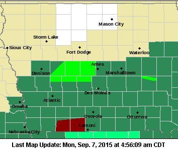
Counties in dark green are under a Flash Flood Watch; Light green: Flood Warning; Counties in dark red: Flash Flood Warning.
The National Weather Service says showers and thunderstorms with potentially heavy flash flooding will continue early this morning, but should diminish toward midday. The overall flash flooding potential will not end by then, however. More showers and thunderstorms with heavy rain are expected again tonight. Rainfall amounts may reach one-to three-inches, with locally higher amounts possible. And, with soils already saturated in many areas, more flash flooding may occur.
A Flood Warning remains in effect until 2-a.m. Tuesday for northern Audubon, Dallas, and Guthrie Counties, along with southeastern Carroll County.
A FLASH FLOOD WATCH continues until 10-a.m. today for Adair-Adams-Audubon-Cass-Dallas-Guthrie-Madison-Ringgold-Taylor and Union Counties in our listening area. A FLOOD WARNING is in effect until 2-a.m. Tuesday for northern Guthrie, southeastern Carroll, northern Audubon and northern Dallas Counties.
Today (Labor Day): A 40 percent chance of showers and thunderstorms, mainly after 3pm. Mostly cloudy, with a high near 83. Northeast wind 6 to 10 mph becoming east southeast in the afternoon. New rainfall amounts between a tenth and quarter of an inch, except higher amounts possible in thunderstorms.
Tonight: Showers and thunderstorms. Some of the storms could produce heavy rain. Low around 67. East southeast wind 3 to 7 mph. Chance of precipitation is 90%. New rainfall amounts between 1 and 2 inches possible.
Tuesday: A 50 percent chance of showers and thunderstorms. Some of the storms could produce heavy rain. Mostly cloudy, with a high near 78. Light and variable wind becoming north 5 to 8 mph in the morning. New rainfall amounts between a tenth and quarter of an inch, except higher amounts possible in thunderstorms.
Tuesday Night: A 20 percent chance of showers and thunderstorms before 1am. Partly cloudy, with a low around 55. North wind around 7 mph.
Wednesday: Sunny, with a high near 76.
Thursday: A 20 percent chance of showers and thunderstorms. Mostly sunny, with a high near 76.
311 AM CDT MON SEP 7 2015
FLOOD WARNING FOR NORTHERN GUTHRIE COUNTY… SOUTHEASTERN CARROLL COUNTY … GREENE COUNTY.. NORTHERN AUDUBON COUNTY … BOONE COUNTY… NORTHERN DALLAS COUNTY UNTIL 2-a.m. TUESDAY.
THE HEAVY RAIN HAS ENDED BUT WIDESPREAD FLOODING IS STILL BEING REPORTED…ESPECIALLY ACROSS NORTHERN GUTHRIE COUNTY.
HIGHWAY 141 IS CLOSED DUE TO FLOODING BETWEEN COON RAPIDS AND HIGHWAY 4. HIGHWAY 25 IS CLOSED AROUND BAYARD DUE TO FLOODING. DETOURS ARE IN PLACE FOR BOTH LOCATIONS.
BE ESPECIALLY CAUTIOUS AT NIGHT WHEN IT IS HARDER TO RECOGNIZE THE DANGERS OF FLOODING. TURN AROUND…DONT DROWN WHEN ENCOUNTERING FLOODED ROADS. MOST FLOOD DEATHS OCCUR IN VEHICLES.
912 PM CDT SUN SEP 6 2015
THE NATIONAL WEATHER SERVICE IN DES MOINES HAS ISSUED A
* FLASH FLOOD WARNING FOR…
NORTHERN GUTHRIE COUNTY IN WEST CENTRAL IOWA…
SOUTHEASTERN GREENE COUNTY IN WEST CENTRAL IOWA…
NORTHERN AUDUBON COUNTY IN WEST CENTRAL IOWA…
SOUTHWESTERN BOONE COUNTY IN CENTRAL IOWA…
NORTHWESTERN DALLAS COUNTY IN CENTRAL IOWA…
* UNTIL 315 AM CDT MONDAY
* AT 910 PM CDT…DOPPLER RADAR AND AUTOMATED RAIN GAUGES INDICATED THUNDERSTORMS PRODUCING HEAVY RAIN ACROSS THE WARNED AREA. UP TO THREE INCHES OF RAIN HAVE ALREADY FALLEN. FLASH FLOODING IS EXPECTED TO BEGIN SHORTLY. 3.1 INCHES OF RAIN HAS FALLEN IN COON RAPIDS SINCE AROUND AN HOUR.
* SOME LOCATIONS THAT WILL EXPERIENCE FLOODING INCLUDE…
PERRY…AUDUBON…LAKE PANORAMA…BAYARD…MINBURN…BAGLEY…
RIPPEY…YALE…JAMAICA…DAWSON…GRAY…BERKLEY…SPRINGBROOK
STATE PARK…PERRY MUNICIPAL AIRPORT AND LAKIN SLOUGH GAME
MANAGEMENT AREA. THE FOLLOWING STREAMS AND CREEKS WILL BE
AFFECTED AS WELL…WILLOW CREEK…BRUSHY CREEK…AND BEAVER CREEK.
PRECAUTIONARY/PREPAREDNESS ACTIONS…
BE ESPECIALLY CAUTIOUS AT NIGHT WHEN IT IS HARDER TO RECOGNIZE THE DANGERS OF FLOODING. TURN AROUND…DONT DROWN WHEN ENCOUNTERING FLOODED ROADS. MOST FLOOD DEATHS OCCUR IN VEHICLES.
650 PM CDT SUN SEP 6 2015
…A SEVERE THUNDERSTORM WARNING REMAINS IN EFFECT UNTIL 715 PM CDT FOR SHELBY COUNTY…
AT 650 PM CDT…A SEVERE THUNDERSTORM WAS LOCATED OVER IRWIN…OR 14 MILES NORTHWEST OF AUDUBON…MOVING NORTHEAST AT 30 MPH.
HAZARD…60 MPH WIND GUSTS AND QUARTER SIZE HAIL.
SOURCE…RADAR INDICATED.
IMPACT…HAIL DAMAGE TO VEHICLES IS EXPECTED. EXPECT WIND DAMAGE TO ROOFS…SIDING AND TREES.
LOCATIONS IMPACTED INCLUDE…
HARLAN…SHELBY…EARLING…IRWIN…DEFIANCE…PANAMA…PORTSMOUTH…
WESTPHALIA…TENNANT…KIRKMAN…NISHNA BEND RECREATION AREA…ELK HORN CREEK RECREATION AREA AND PRAIRIE ROSE STATE PARK. THIS INCLUDES HIGHWAY 59 IN IOWA BETWEEN MILE MARKERS 67 AND 89.
630 PM CDT SUN SEP 6 2015
THE NATIONAL WEATHER SERVICE IN OMAHA HAS ISSUED A
* SEVERE THUNDERSTORM WARNING FOR SHELBY COUNTY UNTIL 715 PM CDT
* AT 630 PM CDT…A SEVERE THUNDERSTORM WAS LOCATED NEAR HARLAN…OR 20 MILES WEST OF AUDUBON…MOVING NORTHEAST AT 25 MPH.
HAZARD…60 MPH WIND GUSTS AND QUARTER SIZE HAIL.
SOURCE…RADAR INDICATED.
IMPACT…HAIL DAMAGE TO VEHICLES IS EXPECTED. EXPECT WIND DAMAGE
TO ROOFS…SIDING AND TREES.
* LOCATIONS IMPACTED INCLUDE…
HARLAN…SHELBY…EARLING…IRWIN…DEFIANCE…PANAMA…
PORTSMOUTH…WESTPHALIA…TENNANT…KIRKMAN…NISHNA BEND
RECREATION AREA…ELK HORN CREEK RECREATION AREA AND PRAIRIE ROSE STATE PARK.
THIS INCLUDES HIGHWAY 59 IN IOWA BETWEEN MILE MARKERS 67 AND 89.
THE NATIONAL WEATHER SERVICE HAS ISSUED SEVERE THUNDERSTORM WATCH 504 IN EFFECT UNTIL 1 AM CDT MONDAY FOR THE FOLLOWING COUNTIES: ADAIR-ADAMS-AUDUBON-CASS-CARROLL-CRAWFORD- GUTHRIE-MADISON-RINGGOLD-SAC-TAYLOR AND UNION.
PROBABILITY TABLE:
PROB OF 2 OR MORE TORNADOES : 10%
PROB OF 1 OR MORE STRONG /F2-F5/ TORNADOES : 02%
PROB OF 10 OR MORE SEVERE WIND EVENTS : 40%
PROB OF 1 OR MORE WIND EVENTS 75 MPH : 10%
PROB OF 10 OR MORE SEVERE HAIL EVENTS : 60%
PROB OF 1 OR MORE HAIL EVENTS 2 INCHES : 30%
PROB OF 6 OR MORE COMBINED SEVERE HAIL/WIND EVENTS : 80%
MAX HAIL /INCHES/ : 2.0
MAX WIND GUSTS SURFACE /MPH/ : 70


