
AREA COUNTIES: MONONA-HARRISON-SHELBY-POTTAWATTAMIE-MILLS-MONTGOMERY-FREMONT-PAGE.
311 PM CDT FRI OCT 16 2015
…FROST ADVISORY IN EFFECT FROM 1 AM TO 9 AM CDT SATURDAY…
THE NATIONAL WEATHER SERVICE IN OMAHA/VALLEY HAS ISSUED A FROST ADVISORY…WHICH IS IN EFFECT FROM 1 AM TO 9 AM CDT SATURDAY.
* TEMPERATURE…TEMPERATURES TONIGHT MAY DIP TO THE MID 30S…WITH COLDER TEMPERATURES POSSIBLE IN FAVORED LOW ELEVATIONS.
* IMPACTS…TENDER VEGETATION MAY BE DAMAGED IF PRECAUTIONS ARE NOT TAKEN.
PRECAUTIONARY/PREPAREDNESS ACTIONS…
A FROST ADVISORY MEANS THAT FROST IS POSSIBLE. SENSITIVE OUTDOOR PLANTS MAY BE KILLED IF LEFT UNCOVERED.
Some much colder conditions have moved into Iowa and National Weather Service meteorologist Brad Fillbach says the first hard freeze of the season for much of the state will arrive early tomorrow (Saturday). “We’re looking at lows in the mid 20s to mid 30s across the state. We do have frost advisories and freeze warnings out,” Fillbach said. The freeze warning for 1 a.m. to 9 a.m. Saturday covers much of northern, eastern and southeastern Iowa.
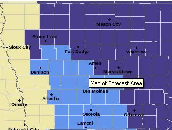
Freeze warning for counties in purple; Frost Advisory for counties in light blue.
High temperatures today (Friday) are forecast for the 40s and 50s. Warmer weather will return soon. “Saturday’s highs will warm back up into the 50s, with 60s by Sunday and Monday,” Fillbach said. Some areas of the state should have temperatures in the 70s on Monday and Tuesday.
A Frost Advisory is in effect from 1-until 9-a.m. Saturday, for parts of the KJAN listening area, including Cass, Adair, Adams, Audubon, Carroll, Crawford, Dallas, Guthrie, Madison, Ringgold, Sac, Taylor and Union Counties.
The first rain chances in several weeks may arrive next week. “We do have chances early next week, but the chances are fairly slight and what rain we do get doesn’t appear to be of any significance,” Fillbach said. NOAA’s Climate Prediction Center released its winter outlook Thursday, and it calls for a slightly warmer-than-normal winter in Iowa, with near normal precipitation.
(Radio Iowa)
Today: Frost Advisory until 9-a.m.; Mostly Sunny. High near 58. N @ 10.
Tonight: Becoming partly cloudy. Low around 30.
Saturday: Frost Advisory from 1-am-to 9-a.m.; P/Cldy. High near 61. SE @ 10-15.
Sat. Night: Mostly clear, with a low around 39
Sunday: P/Cldy & breezy. High near 70.
Monday: P/Cldy & windy. High near 80.
Thursday’s High in Atlantic was 70. Our 24-hour Low ending at 7-a.m. today was 30. Last year on this date, our High was 74 and the Low was 35.
The All-time Record High in Atlantic on Oct. 16th was 87 in 1921. The All-Time record low was 20 in 1976 & 1977. Sunrise today is at 7:33, and sunset tonight will take place at 6:38.
The Shelby County Emergency Management Agency says the grassland/field fire danger level will remain “HIGH” through this weekend. Continued drying conditions, make the potential for grassland and standing corn fires higher than normal. Caution should be observed when burning and, notices provided to your local Fire Chief . 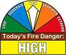
The next local update will be Monday October 19th.
Early This Morning: Clear…colder. Areas of frost. North wind near 10 mph.
Today: Frost Advisory until 9-a.m.; Sunny…cooler. Areas of frost through mid morning. High in the mid 50s. Northwest wind 5 to 10 mph.
Tonight: Partly cloudy. Patchy frost early in the morning. Low in the mid 30s. North wind near 5 mph shifting to the southeast after midnight.
Saturday: Frost Advisory from 1-a.m. until 9-a.m.; Mostly sunny. Patchy frost through mid morning. High in the upper 50s. Southeast wind near 10 mph shifting to the south in the afternoon.
Saturday Night: Mostly clear. Low in the upper 30s. Southeast wind 5 to 10 mph.
Sunday: Sunny…breezy. High in the upper 60s. South wind 5 to 15 mph increasing to 15 to 20 mph in the afternoon.
Sunday Night: Partly cloudy. Warmer. Low around 50.
Monday: Mostly sunny. Breezy. High in the mid 70s.
(Issued 3:54-a.m.) COUNTIES affected: SAC-CRAWFORD-CARROLL-AUDUBON-CASS-ADAMS-TAYLOR–HARRISON-SHELBY-POTTAWATTAMIE-MILLS-MONTGOMERY-FREMONT-PAGE.
A FROST ADVISORY REMAINS IN EFFECT UNTIL 9 AM CDT THIS MORNING.
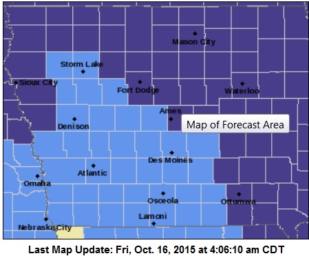
Frost Advisory for counties in light blue; Freeze Warning for counties shown in purple.
A FROST ADVISORY WILL BE IN EFFECT FROM 1 AM TO 9 AM CDT SATURDAY, FOR:SAC-CRAWFORD-CARROLL-AUDUBON-CASS-ADAMS-TAYLOR GUTHRIE-DALLAS-ADAIR-MADISON- UNION AND RINGGOLD COUNTIES.
TEMPERATURE READINGS MAY DIP INTO THE 30S EARLY THIS MORNING AND THE LOWER 30S EARLY SATURDAY MORNING. AREAS OF FROST ARE EXPECTED TO FORM EARLY THIS MORNING AND AGAIN EARLY SATURDAY MORNING. THESE CONDITIONS WILL LIKELY DAMAGE OR KILL SENSITIVE VEGETATION THAT HAS BEEN LEFT UNPROTECTED.
Today: Clear to P/Cldy & breezy. High near 70. W/NW @ 10-20 w/gusts to near 30.
Tonight: Areas of frost after 4am. Mo. Clear. Low around 32. N/NW 5-10. .
Friday: **Frost Advisory 3-am to 9-am**Areas of frost before 8-am, otherwise Sunny. High near 58. N/NW @ 5-10.
Fri. Night: Partly cloudy. Low around 34.
Saturday: P/Cldy. High near 61. S/SE wind 5 to 15 mph.
Saturday Night: Mostly clear, with a low around 39.
Sunday: P/Cldy & breezy. High near 68.
WEATHER DATA: Wednesday’s High in Atlantic was 72. Our 24-hour Low ending at 7-a.m. today was 37. Last year on this date, our High was 69 and the Low was 33.
The All-time Record High in Atlantic on Oct. 15th was 89 in 1892. The All-Time record low was 17 in 1952. Sunrise today is at 7:31, and sunset tonight will take place at 6:39.
Today: Mostly sunny. Breezy. High in the upper 60s. West wind 5 to 10 mph increasing to north 15 to 20 mph with gusts to around 30 mph in the afternoon.
Tonight: Clear. Areas of frost early in the morning. Low in the mid 30s. Northwest wind 5 to 10 mph. Gusts up to 20 mph through midnight.
Friday: **FROST ADVISORY beginning at 3-a.m.**Sunny…cooler. Areas of frost through mid morning. High in the mid 50s. Northwest wind 5 to 10 mph.
Friday Night: Partly cloudy. Low in the mid 30s. North wind near 5 mph shifting to the east after midnight.
Saturday: Mostly sunny. High in the upper 50s. Southeast wind 5 to 15 mph.
Saturday Night: Mostly clear. Low in the upper 30s.
Sunday: Mostly sunny. Breezy. High in the mid 60s.
Special Weather statement for the following KJAN listening area counties: SAC-CRAWFORD-CARROLL-AUDUBON-GUTHRIE-DALLAS-CASS-ADAIR-MADISON-ADAMS-UNION-TAYLOR-RINGGOLD
338 AM CDT THU OCT 15 2015
…STRONG WINDS AND DRY CONDITIONS LEAD TO HIGH FIRE DANGER…
NORTHWEST WINDS WILL INCREASE SUBSTANTIALLY TODAY BECOMING VERY GUSTY BY THE AFTERNOON. RELATIVE HUMIDITY WILL ALSO FALL TO VERY LOW VALUES IN THE 20S THIS AFTERNOON. AS A RESULT, CONDITIONS
WILL BE HAZARDOUS FOR BURNING OR ANY FIRES THAT START AS THEY MAY BE ABLE TO SPREAD QUICKLY…ESPECIALLY IN FIELDS OR AREAS WHERE SURFACE VEGETATION HAS CURED.
ANY BURNING IS STRONGLY DISCOURAGED, AND THOSE ENGAGING IN HARVESTING ACTIVITIES SHOULD BE AWARE OF THE INCREASED FIRE THREAT.
401 AM CDT THU OCT 15 2015
FROST EXPECTED OVER WESTERN IOWA TONIGHT. A COLD FRONT IS EXPECTED TO PUSH THROUGH IOWA LATER TODAY ALLOWING TEMPERATURES TO DROP INTO THE 30S FOR OVERNIGHT LOWS. HIGH PRESSURE WILL SETTLE BEHIND INTO THE HIGH PLAINS WITH CLEAR SKIES AND LIGHT WINDS ALLOWING FOR FAVORABLE CONDITIONS FOR FROST DEVELOPMENT…ESPECIALLY IN THE NISHNABOTA VALLEY.
CASS-ADAMS-AUDUBON-CARROLL-CRAWFORD-FREMONT-HARRISON-MILLS-MONTGOMERY-PAGE-SHELBY-TAYLOR COUNTIES…
FROST ADVISORY IN EFFECT FROM 3 AM TO 9 AM CDT FRIDAY.
* TEMPERATURE…OVERNIGHT LOWS ARE EXPECTED TO DIP INTO THE MIDDLE 30’S.
* IMPACTS…AREAS OF FROST ARE EXPECTED TO FORM DURING THE EARLY MORNING HOURS FRIDAY…LIKELY IMPACTING SENSITIVE VEGETATION THAT HAS BEEN LEFT UNPROTECTED.
PRECAUTIONARY/PREPAREDNESS ACTIONS…
A FROST ADVISORY MEANS THAT FROST IS POSSIBLE. SENSITIVE OUTDOOR PLANTS MAY BE KILLED IF LEFT UNCOVERED OR NOT BROUGHT INDOORS.


