


Freeze warning for much of Iowa Saturday morning
October 16th, 2015 by Ric Hanson
Some much colder conditions have moved into Iowa and National Weather Service meteorologist Brad Fillbach says the first hard freeze of the season for much of the state will arrive early tomorrow (Saturday). “We’re looking at lows in the mid 20s to mid 30s across the state. We do have frost advisories and freeze warnings out,” Fillbach said. The freeze warning for 1 a.m. to 9 a.m. Saturday covers much of northern, eastern and southeastern Iowa.
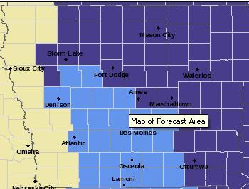
Freeze warning for counties in purple; Frost Advisory for counties in light blue.
High temperatures today (Friday) are forecast for the 40s and 50s. Warmer weather will return soon. “Saturday’s highs will warm back up into the 50s, with 60s by Sunday and Monday,” Fillbach said. Some areas of the state should have temperatures in the 70s on Monday and Tuesday.
A Frost Advisory is in effect from 1-until 9-a.m. Saturday, for parts of the KJAN listening area, including Cass, Adair, Adams, Audubon, Carroll, Crawford, Dallas, Guthrie, Madison, Ringgold, Sac, Taylor and Union Counties.
The first rain chances in several weeks may arrive next week. “We do have chances early next week, but the chances are fairly slight and what rain we do get doesn’t appear to be of any significance,” Fillbach said. NOAA’s Climate Prediction Center released its winter outlook Thursday, and it calls for a slightly warmer-than-normal winter in Iowa, with near normal precipitation.
(Radio Iowa)

