
401 AM CDT THU OCT 15 2015
FROST EXPECTED OVER WESTERN IOWA TONIGHT. A COLD FRONT IS EXPECTED TO PUSH THROUGH IOWA LATER TODAY ALLOWING TEMPERATURES TO DROP INTO THE 30S FOR OVERNIGHT LOWS. HIGH PRESSURE WILL SETTLE BEHIND INTO THE HIGH PLAINS WITH CLEAR SKIES AND LIGHT WINDS ALLOWING FOR FAVORABLE CONDITIONS FOR FROST DEVELOPMENT…ESPECIALLY IN THE NISHNABOTA VALLEY.
CASS-ADAMS-AUDUBON-CARROLL-CRAWFORD-FREMONT-HARRISON-MILLS-MONTGOMERY-PAGE-SHELBY-TAYLOR COUNTIES…
FROST ADVISORY IN EFFECT FROM 3 AM TO 9 AM CDT FRIDAY.
* TEMPERATURE…OVERNIGHT LOWS ARE EXPECTED TO DIP INTO THE MIDDLE 30’S.
* IMPACTS…AREAS OF FROST ARE EXPECTED TO FORM DURING THE EARLY MORNING HOURS FRIDAY…LIKELY IMPACTING SENSITIVE VEGETATION THAT HAS BEEN LEFT UNPROTECTED.
PRECAUTIONARY/PREPAREDNESS ACTIONS…
A FROST ADVISORY MEANS THAT FROST IS POSSIBLE. SENSITIVE OUTDOOR PLANTS MAY BE KILLED IF LEFT UNCOVERED OR NOT BROUGHT INDOORS.
The latest U-S-D-A crop report shows the harvest is 12 days ahead of last year for corn and 10 days ahead for soybeans, but one section of the state is lagging well behind those numbers. Iowa State University agronomist Aaron Saeugling monitors 12-southwest Iowa counties. “In southwest Iowa it’s going to be a long fall,” Saeugling says.
That’s because constant rains, some often several inches, delayed planting and kept some fields from being planted. That makes for a lot of different scenarios in the fields. ”I’ve got producers who are wrapping up soybeans and I’ve got producers that haven’t started,” according to Saeugling.
It’s not all of southwest Iowa — not even all of some farms. “So for those guys it’s kind of bittersweet,” Saeugling says, “they’ve got fields that are yielding better than they ever dreamed of. They’ve got fields they won’t harvest.” Either way, the area is well behind the statewide average for corn of 20 percent harvested and 65 percent for soybeans. “If I had to average — probably pushing really close to fifty-percent on beans. Corn right now, maybe twenty percent,” Saeugling estimates.
In contrast, in northwest Iowa where things were drier, an agronomist reports two-thirds of the corn and nearly all of the soybeans are already harvested.
(Radio Iowa)
Today: Partly Cloudy. High Around 70. NW wind @ 10mph.
Tonight: P/Cldy. Low 40. Winds light & variable.
Tomorrow: P/Cldy to Cldy w/isolated shwrs possible. High 70. S-N @ 10-15.
Tom. Night: Mo. Clear. Low around 35.
Friday: Mostly Sunny. High around 59.
Friday night: P/Cldy w/areas of frost after midnight. Low around 32.
Saturday: P/Cldy. High 61.
Tuesday’s High in Atlantic was 75. Our 24-hour Low ending at 7-a.m. today was 37.
Last year on this date, our High was 65 and the Low was 33.
The All-time Record High in Atlantic on Oct. 14th was 88 in 1897. The All-Time record low was 16 in 1937. Sunrise today is at 7:30, and sunset tonight will take place at 6:41.
Early This Morning: Clear. Northwest wind 5 to 15 mph with gusts to around 25 mph.
Today: Sunny. High in the lower 70s. Northwest wind around 5 mph.
Tonight: Partly cloudy. Low in the mid 40s. Southwest wind around 5 mph.
Thursday: Mostly sunny. High in the upper 60s. West wind near 10 mph shifting to the north with gusts to around 25 mph in the afternoon.
Thursday Night: Mostly clear. Colder. Low in the mid 30s. North wind 5 to 10 mph.
Friday: Sunny…cooler. High in the mid 50s. North wind 5 to 10 mph.
Friday Night: Partly cloudy. Areas of frost after midnight. Low in the lower 30s.
Saturday: Sunny. High in the upper 50s.
We’re almost a month into fall and already talk is turning to the winter ahead. The weather pattern known as El Nino continues to strengthen and promises to be one of the strongest on record. State climatologist Harry Hillaker says it could mean Iowans are in store for a less severe winter ahead. “The stronger the El Nino becomes, generally, the higher the odds are that we’d have a warmer-than-normal mid-winter period in Iowa,” Hillaker says. “That would be from roughly early to mid-December to the early part of March.”
That’s usually the coldest time of the year anyway, so Hillaker warns it will still be cold, perhaps just not as cold as during a typical winter. Still, he says not to bet on the warmer winter. “Every once in a while, we do get exceptions to this tendency for mild El Nino winters in Iowa,” Hillaker says. “The last El Nino event, which was a medium-strength event six years ago, ended up bringing us an unusually cold and snowy winter.”
The El Nino is characterized by warm water in the central and east-central Pacific Ocean. Forecasters say the last time the El Nino system promised to be this strong was during the winter of 1997-98, which ended up being one of Iowa’s warmer winters on record.
(Radio Iowa)
Today: Mostly Sunny. High around 70. NW @ 10.
Tonight: Fair to Partly Cloudy. Low near 36.
Tomorrow: Partly Cloudy. High near 70. Variable breeze @ 5-10mph.
Thursday: Mostly Cloudy w/a chance of light rain. High around 65. Winds switching from the S/SW in the morning to N/NW at 15-25mph, Thu. afternoon.
Friday: Partly Cloudy & cooler. High 59.
Football Friday night: Mostly clear w/areas of frost after midnight. Low around 33.
Monday’s High in Atlantic was 72. Our 24-hour Low ending at 7-a.m. today was 36.
Last year on this date, our High was 53 and the Low was 47.
The All-time Record High in Atlantic on Oct. 13th was 88 in 1975. The All-Time record low was 15 in 1907. Sunrise today is at 7:29, and sunset tonight will take place at 6:42.
Early This Morning: Clear…colder. Northwest wind 5 to 10 mph.
Today: Sunny. High in the lower 70s. Northwest wind 5 to 15 mph.
Tonight: Mostly clear. Low in the mid 40s. Northwest wind near 5 mph.
Wednesday: Sunny. High in the upper 60s. Northwest wind around 5 mph.
Wednesday Night: Partly cloudy. Low in the upper 40s. South wind near 5 mph.
Thursday: Mostly sunny. High around 70. West wind 5 to 10 mph shifting to the northwest 10 to 15 mph with gusts to around 25 mph in the afternoon.
Thursday Night: Partly cloudy. Colder. Low in the upper 30s.
Friday: Sunny…cooler. High in the upper 50s.
Atlantic Fire Chief Mark McNees reports Cass County Fire Chiefs have been discussing a possible Burn Ban for Cass County. The Chiefs contacted Cass County Emergency Management Director Mike Kennon, after receiving some concerns by local residents. McNees says at this time, the overall consensus is to remind residents that conditions today (Monday) are very dangerous and ANY open burning should not be conducted. All precautions should be taken by farmers harvesting their crops to clean and maintain their equipment to help prevent equipment fires that could easily result in a large out of control field fire.
Atlantic Chief Mark McNees says also, “ At this moment it seems to be a typical fall harvest season with a large fuel load of unharvested crops. However, there are still reasonably green areas surrounding fields and some areas that are fairly wet in parts of the county. At the current pace, and with the two week outlook in the forecast, it appears much of the harvest will be completed within 2 to 3 weeks. I would not encourage any open burning until later in the fall or early winter when the crops are out and there may have been some more precipitation. It would be best to wait as long as possible. If conditions worsen greatly a ban may be issued and residents will be advised.”
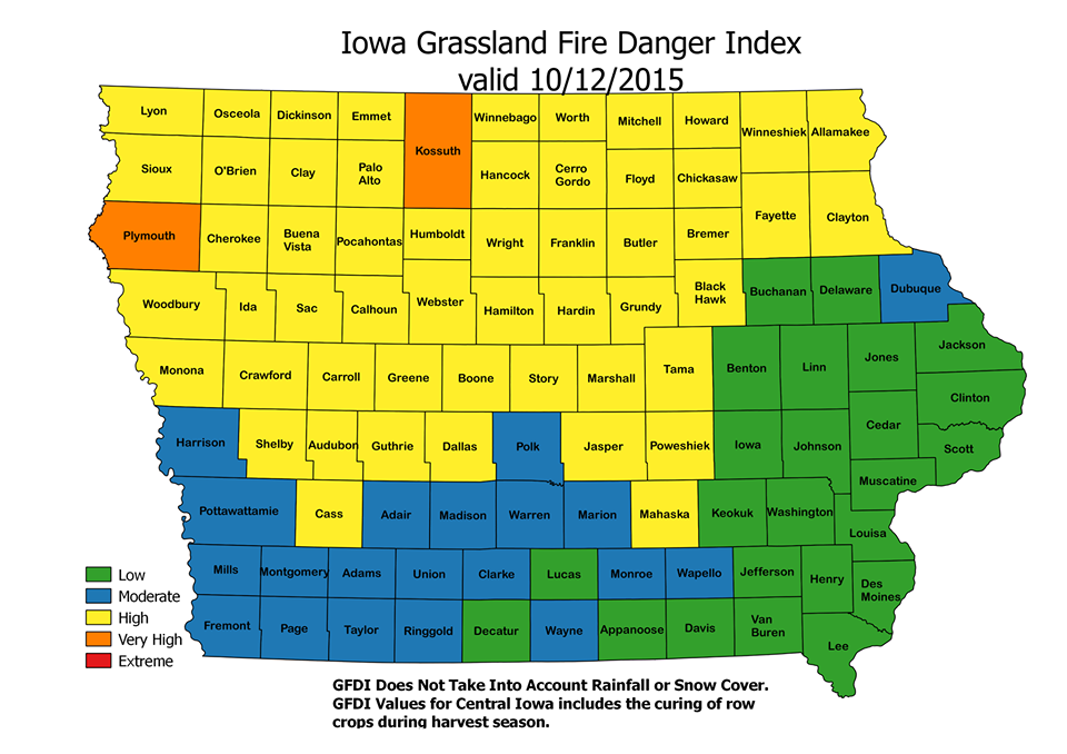
Grassland Fire Danger Index 10/12/15
It is best always to contact your local fire department chief before any burns are conducted to get their advice and to give notice that a burn is being planned. Cass County has been very successful the past few years in keeping wildland fires from occurring by communicating with residents in this regard.
McNees added, “Several area departments have specifically trained to conduct prescribed burns for CRP mid management burns, and have instituted programs to do other planned, controlled burns for landowners in their districts. This provides a much safer and timely outcome for everyone. Fire departments can train, plan, and conduct land burns at times when they have personnel, and landowners benefit from the control of such burns.”
Landowners are encouraged to contact their departments now if they would like to discuss such burns, including the timing, areas, and costs. McNees says “ last year Atlantic began a program for prescribed burns and it became difficult to get them all done when several waited until late to make requests. Departments want to stay within their districts, but will aid neighboring departments if necessary, which is another reason to contact your department to see if they have such a program instituted and can assist the landowner.”
Today: WIND ADVISORY 10-am to 6-pm; Partly Cloudy & windy. High near 70. NW @ 20-35mpg w/gusts to near 45.
Tonight: Mo. Clear & breezy. Low around 35. NW @ 15-25.
Tuesday: P/Cldy. High near 70. SE @ 5-10.
Tue. Night: Mostly clear, with a low around 46.
Wednesday: P/Cldy. High near 70. N.NW @ 5-10.
Wednesday Night: Partly cloudy, with a low around 46.
Thursday: P/Cldy to Cldy w/a chance of late day shwrs. High 72.
Sunday’s High in Atlantic was 86. Our 24-hour Low ending at 7-a.m. today was 54.
Last year on this date, our High was 59 and the Low was 46.
The All-time Record High in Atlantic on Oct. 12th was 90 in 1899. The All-Time record low was 17 in 1908. Sunrise today is at 7:28, and sunset tonight will take place at 6:44.
Early This Morning: Partly cloudy. Northwest wind 10 to 15 mph.
Today: **WIND ADVISORY from 10-a.m. until 6-p.m.** Sunny…breezy…cooler. High in the lower 70s. Northwest wind 10 to 25 mph increasing to 20 to 25 mph in the afternoon. Gusts up to 45 mph.
Tonight: Clear…colder. Low in the lower 40s. Northwest wind 5 to 15 mph. Gusts up to 30 mph through midnight.
Tuesday: Sunny. High in the upper 60s. Northwest wind 5 to 10 mph.
Tuesday Night: Mostly clear. Low in the upper 40s. Southwest wind near 5 mph shifting to the west around 5 mph after midnight.
Wednesday: Sunny. High in the lower 70s. Northwest wind 5 to 10 mph.
Wednesday Night: Partly cloudy. Low in the mid 40s.
Thursday: Mostly sunny. High around 70.


