
Today: Sunny, with a high near 26. Wind chill values as low as 10. North wind 7 to 13 mph becoming west in the afternoon.
Tonight: Increasing clouds, with a low around 15. Wind chill values as low as 5. West wind 5 to 8 mph becoming south in the evening.
Sunday: Sunny, with a high near 40. Wind chill values as low as 5. West southwest wind 6 to 13 mph.
Sunday Night: Mostly clear, with a low around 24. West wind 6 to 11 mph.
Monday: Sunny, with a high near 42. West wind around 6 mph becoming southeast in the afternoon.
Tuesday: Mostly sunny, with a high near 46.
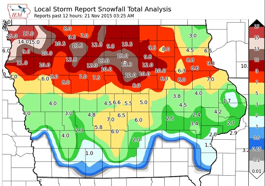
Friday’s High in Atlantic was 40. We received 1.5-inches of snow here at the KJAN studios Friday. The snow-rain mix resulted in a liquid precipitation value of .14″.
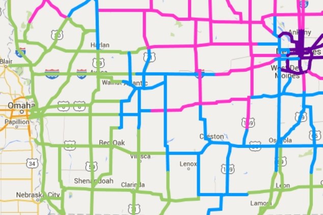
Green: Seasonal travel conditions
Blue: Partially covered with snow (watch out for icy bridges)
Pink: Completely covered with snow, ice or slush. (go to 511.ia.org for the latest info., or call 5-1-1 in Iowa)
A WINTER STORM WARNING REMAINS IN EFFECT FROM 2-PM FRIDAY UNTIL 6 AM SATURDAY FOR AUDUBON-GUTHRIE AND DALLAS COUNTIES; FROM 3-PM FRIDAY THROUGH 3-AM SATURDAY FOR MONONA, HARRISON AND SHELBY COUNTIES, AND FROM 10-AM FRIDAY THROUGH 6-AM SATURDAY FOR SAC-CRAWFORD-AND CARROLL COUNTIES.
* TIMING…SNOW IS EXPECTED TO BEGIN ACROSS THE AREA DURING THE
AFTERNOON HOURS AND MAY HAVE A SIGNIFICANT IMPACT ON THE LATE
AFTERNOON AND EARLY EVENING COMMUTE.
* STORM TOTAL SNOW ACCUMULATIONS…6 TO 10 INCHES POSSIBLE.
* WINDS/VISIBILITIES…VISIBILITIES WILL BE REDUCED TO LESS THAN
ONE HALF MILE AT TIMES IN FALLING SNOW. IN ADDITION…WINDS OF
15 TO 25 MPH MAY PRODUCE MINOR BLOWING AND DRIFTING…AND ALSO
HELP CONTRIBUTE TO REDUCED VISIBILITIES.
* IMPACTS…THE COMBINATION OF SLUSHY AND SNOW COVERED ROADS WILL
LEAD TO HAZARDOUS TRAVEL CONDITIONS…INCLUDING DURING THE
FRIDAY EVENING COMMUTE. TRAVEL CONDITIONS WILL LIKELY BECOME
TREACHEROUS AT TIMES.
MODERATE TO HEAVY SNOW TODAY AND TONIGHT. .THE FIRST WINTER STORM OF THE SEASON WILL IMPACT A LARGE PORTION OF IOWA TODAY AND TONIGHT. SNOW HAS BEGUN ACROSS NORTHWESTERN AND
NORTHERN IOWA AND WILL SPREAD ACROSS THE REMAINDER OF THE AREA
THIS AFTERNOON AND EVENING. BREEZY NORTHERLY WINDS FRIDAY NIGHT MAY CAUSE AREAS OF BLOWING AND DRIFTING OF SNOW.
A WINTER WEATHER ADVISORY REMAINS IN EFFECT FROM 2-PM FRIDAY UNTIL 6 AM CST SATURDAY FOR CASS-ADAIR-ADAMS-UNION COUNTIES, AND FROM 3-PM FRIDAY UNTIL 3-AM SATURDAY FOR POTTAWATTAMIE AND MONTGOMERY COUNTIES.
* TIMING…THE PRECIPITATION IS EXPECTED TO BEGIN AS RAIN BEFORE
TRANSITIONING TO SNOW BY MID TO LATE FRIDAY AFTERNOON THEN
CONTINUE OVERNIGHT. THE SNOW MAY BECOME HEAVY AT TIMES.
* STORM TOTAL SNOW ACCUMULATIONS…3 TO 6 INCHES POSSIBLE.
* WINDS/VISIBILITIES…VISIBILITIES WILL BE REDUCED TO LESS THAN
ONE HALF MILE AT TIMES IN FALLING SNOW. IN ADDITION…WINDS OF
15 TO 25 MPH MAY PRODUCE MINOR BLOWING AND DRIFTING…AND ALSO
HELP CONTRIBUTE TO REDUCED VISIBILITIES.
* IMPACTS…THE COMBINATION OF SLUSHY AND SNOW COVERED ROADS MAY LEAD TO HAZARDOUS TRAVEL CONDITIONS…INCLUDING DURING THE
FRIDAY EVENING COMMUTE. TRAVEL CONDITIONS WILL LIKELY BECOME
HAZARDOUS AT TIMES.
PRECAUTIONARY/PREPAREDNESS ACTIONS…
A WINTER WEATHER ADVISORY FOR SNOW MEANS THAT PERIODS OF SNOW
WILL CAUSE PRIMARILY TRAVEL DIFFICULTIES. BE PREPARED FOR SNOW
COVERED ROADS AND LIMITED VISIBILITIES…AND USE CAUTION WHILE
DRIVING.
(Information current as of 8:30-a.m. 11/20)
A WINTER WEATHER ADVISORY (which replaces a Winter Storm Watch) is in effect from 2-pm today (Friday) until 6-am Saturday, for Cass, Adair, Adams and Union Counties. The Advisory is in effect from 3-p.m today until 3-am Saturday, for Pottawattamie and Montgomery Counties. 3-to 6-inches of snow are possible in the Advisory area. 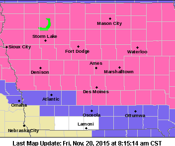
A WINTER STORM WARNING remains in effect from 3-pm today to 3-a.m. Saturday, for Monona, Harrison and Shelby Counties, from 2-p.m. today until 6-am Saturday for Audubon, Guthrie and Dallas Counties, and from 10-am today until 6-am Saturday, for Sac, Crawford and Carroll Counties. 6-to 10-inches of snow are possible in the warned area.
Forecasters say a wide section of Iowa may get walloped by its first significant snowstorm later today (Friday), so motorists need to take a few precautions, pronto. Ann Avery, the Iowa spokeswoman for State Farm Insurance, says an emergency kit is a must for your vehicle’s trunk. “With the first snowfall of the season coming and Thanksgiving travel beginning for many families, now is a great time to think about looking in your trunk and taking out the things you’ve been using all summer that you won’t be using this winter and making sure you have emergency travel supplies,” Avery says, “so if you are on the road and something unexpected happens, you will be prepared.”
There are several staples that should be in everyone’s vehicle, before the winter winds start whipping. “Some of the things include: jumper cables and making sure you have an ice scraper back in the car,” Avery says. “Check the spare tire, make sure it’s in the car and that it’s at the proper inflation. Be sure you have blankets, extra warm clothing. A cell phone charger — we depend on that cell phone. If you get into an emergency, make sure you are able to charge it.”
Other helpful items to have handy include: road salt or cat litter to help with tire traction, a flashlight (with working batteries), matches or a lighter, duct tape, a small tool kit and a tow strap. Avery offers a few more suggestions. “A first aid kit, water, food that won’t expire in the trunk, and crucial medications,” Avery says. “If you should get caught and stuck on the side of the road, you want to make sure you have those medications.” If there’s a teenage driver under your roof, Avery says you should talk to them about the importance of this kit.
“Our information shows a lot of teens reported not having all the necessary supplies they need in their trunk,” Avery says. “Check the car the teen is using as well. Have them put the emergency kit together with you so they see what goes into it and understand why it’s all there.” Other items that you might consider for your emergency kit are: a hazard triangle with reflectors, flares, a brightly-colored flag or “HELP” sign, and a tarp for sitting or kneeling in the snow for doing exterior work like a tire change.
(Radio Iowa)
A WINTER STORM WATCH REMAINS IN EFFECT FROM 2-P.M. TODAY (FRIDAY) THROUGH 6-AM SATURDAY FOR: CASS and ADAIR COUNTIES, , AND FROM 3-PM TODAY THROUGH 3-AM SATURDAY, FOR POTTAWATTAMIE and MONTGOMERY COUNTY. 
THREE TO SIX-INCHES OF SNOW ARE POSSIBLE IN THE WATCH AREA.
A WINTER STORM WARNING REMAINS IN EFFECT FROM 3-PM TODAY UNTIL 3-A.M. SATURDAY FOR MONONA, HARRISON AND SHELBY COUNTIES; FROM 2-PM TODAY UNTIL 6-AM SATURDAY FOR AUDUBON-GUTHRIE-AND DALLAS COUNTIES; AND FROM 10-AM TODAY UNTIL 6-AM SATURDAY FOR SAC-CRAWFORD AND CARROLL COUNTIES IN THE KJAN LISTENING AREA.
5-TO 9 INCHES OF SNOW ARE POSSIBLE IN THE WARNED AREA.
(Winter Storm Warnings or Watches will be in effect later today – see the Weather page at kjan.com for details.)
Today: Rain and snow, becoming all snow after 4pm. High near 39. Breezy, with an east wind 5 to 10 mph increasing to 12 to 17 mph in the morning. Winds could gust as high as 24 mph. Chance of precipitation is 100%. New snow accumulation of 1 to 2 inches possible.
Tonight: Snow, mainly before 1am. Low around 20. Blustery, with an east northeast wind 14 to 18 mph becoming north after midnight. Winds could gust as high as 26 mph. Chance of precipitation is 100%. New snow accumulation of 2 to 4 inches possible.
Saturday: Sunny, with a high near 26. Wind chill values as low as 5. North wind 8 to 14 mph becoming west in the afternoon. Winds could gust as high as 18 mph.
Saturday Night: Partly cloudy, with a low around 11. West wind around 6 mph becoming light and variable.
Sunday: Sunny, with a high near 36.
Monday: Sunny, with a high near 42.
A WINTER STORM WATCH REMAINS IN EFFECT FROM 2-P.M. TODAY (FRIDAY) THROUGH 6-AM SATURDAY FOR: CASS-ADAIR-AND MADISON COUNTIES, AND FROM 9-AM TODAY THROUGH MIDNIGHT FOR HARRISON AND POTTAWATTAMIE COUNTIES. 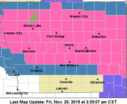
THREE TO SIX-INCHES OF SNOW ARE POSSIBLE IN THE WATCH AREA.
A WINTER STORM WARNING REMAINS IN EFFECT FROM 9-AM TODAY UNTIL MIDNIGHT FOR MONONA AND SHELBY COUNTIES; FROM 2-PM TODAY UNTIL 6-AM SATURDAY FOR AUDUBON-GUTHRIE-AND DALLAS COUNTIES; AND FROM 10-AM TODAY UNTIL 6-AM SATURDAY FOR SAC-CRAWFORD AND CARROLL COUNTIES IN THE KJAN LISTENING AREA.
5-TO 9 INCHES OF SNOW ARE POSSIBLE IN THE WARNED AREA.


