
Today: **Winter Storm Warning until 6-p.m.** Cloudy w/fog & mixture of rain, freezing rain and sleet becoming wet snow this afternoon. High around 33. E/SE @ 10-20.
Tonight: Snow ending this evening, w/areas of flurries or freezing drizzle overnight (2-4” snow total). Low 29 W @ 10-20.
Tomorrow: Mo Cldy w/flurries, drizzle or freezing drizzle. High 33. W @ 10-20.
Wednesday: Mo. Cldy. High 35.
Thursday: P/Cldy. High 40.
Sunday’s High in Atlantic was 34. Our 24-hour low ending today at 7-a.m. was 29. We received .26” of precipitation over the past 24-hours. Last year on this date we reached 23 for a High and 11 was the low. The All-time Record High in Atlantic on this date was 66 in 1922, while the Record Low was -10 in 1964.
Sunrise is at 7:25-a.m.. Sunset is 4:51-p.m.
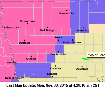
A WINTER STORM WARNING remains in effect until 6-p.m. today (Monday) for Cass-Adair-Audubon-Guthrie-Dallas-Crawford-Carroll-Pottawattamie-and Mills Counties, and until midnight for Monona-Harrison and Shelby Counties.
 In the immediate KJAN listening area, widespread freezing rain this morning is expected to transition to snow by early this afternoon and then back to rain. Total snow accumulations of 1-3″ can be expected, with ice accumulating to two- to three- tenths of an inch. This may lead to hazardous travel conditions, especially this morning. The heavy, wet snow will also be difficult to remove. 2-to 5 inches of snow is possible in counties west/northwest of Cass.
A WINTER WEATHER ADVISORY remains in effect until 6-pm today for Adams-Madison-Union-Taylor and Ringgold Counties, where freezing rain and drizzle is expected, with up to 1/10th of an inch possible.
**Winter Storm Warning until 6-p.m. today (Monday)**
Early this morning: A chance of freezing rain before 4am, then a chance of rain between 4am and 5am, then freezing rain after 5am. Steady temperature around 33. East wind around 9 mph. Chance of precipitation is 80%. Total nighttime ice accumulation of 0.1 to 0.2 of an inch possible.
Today: Snow and freezing rain, possibly mixed with rain before 2pm, then rain, possibly mixed with snow between 2pm and 4pm, then rain likely after 4pm. High near 35. East wind 6 to 8 mph becoming south southeast in the afternoon. Chance of precipitation is 100%. New ice accumulation of 0.1 to 0.2 of an inch possible. New snow accumulation of 1 to 2 inches possible.
Tonight: Rain and freezing rain likely, possibly mixed with snow before 10pm, then snow likely, possibly mixed with freezing rain between 10pm and 11pm, then snow likely after 11pm. Cloudy, with a low around 27. South wind 6 to 15 mph becoming west southwest after midnight. Winds could gust as high as 21 mph. Chance of precipitation is 60%. Little or no ice accumulation expected. New snow accumulation of less than a half inch possible.
Tuesday: A 20 percent chance of snow. Cloudy, with a high near 33. Breezy, with a west southwest wind 13 to 17 mph, with gusts as high as 25 mph.
Wednesday: Mostly sunny, with a high near 35.
CASS-ADAIR-AUDUBON-GUTHRIE-DALLAS Counties: Winter Storm Warning in effect from Midnight Sunday until 6-p.m. Monday. Look for ice accumulations of one-to two-tenths of an inch and snowfall from one-to three-inches.
ADAMS-MADISON, UNION-TAYLOR-RINGGOLD COUNTIES: Winter Weather Advisory in effect from Midnight Sunday until 6-p.m. Monday.
POTTAWATTAMIE COUNTY: Winter Storm Warning in effect from Midnight Sunday until 6-p.m. Monday. The Winter Storm Watch is no longer in effect. Expect up to one-tenth of an inch of ice and 2-to 4-inches of snow.
MONONA-HARRISON-SHELBY COUNTIES: Winter Storm Warning in effect from 3-a.m. Monday until Midnight, Monday. The Winter Storm Watch is no longer in effect. Expect up to one-tenth of an inch of ice and 3-to 5-inches of snow.
MILLS-MONTGOMERY-FREMONT AND PAGE COUNTIES: Winter Weather Advisory from 9-p.m. Sunday until 6-p.m. Monday. The Winter Storm Watch is no longer in effect. Expected up to one-tenth of an inch of ice and 1-2″ of snow.
AREA COUNTIES: ADAMS-UNION-TAYLOR-RINGGOLD
449 AM CST SUN NOV 29 2015
A WINTER WEATHER ADVISORY THAT WAS SET TO EXPIRE AT 6-A.M. TODAY (SUNDAY), IS NOW IN EFFECT UNTIL 9 AM.
* SHORT TERM TRENDS…FREEZING RAIN SHOWERS CONTINUE ACROSS THE
AREA WITH LIGHT ICING CONDITIONS OCCURRING ON HIGHWAYS ACROSS
THE REGION. THESE SHOWERS WILL CONTINUE THROUGH THE MORNING WITH GRADUALLY WARMING TEMPERATURES BRINGING THE THREAT FOR WIDESPREAD FREEZING RAIN TO AN END BY MID MORNING.
* ICE ACCUMULATIONS…AMOUNTS LESS THAN ONE TENTH OF AN INCH OF
ICE WILL BE POSSIBLE.
* IMPACTS…ROADS AND WALKWAYS WILL BECOME ICY. TRAVEL MAY
BECOME HAZARDOUS…ESPECIALLY ON BRIDGES AND UNTREATED
SURFACES.
PRECAUTIONARY/PREPAREDNESS ACTIONS…
A WINTER WEATHER ADVISORY MEANS THAT PERIODS OF FREEZING RAIN
WILL CAUSE TRAVEL DIFFICULTIES. BE PREPARED FOR SLIPPERY ROADS
AND LIMITED VISIBILITIES…AND USE CAUTION WHILE DRIVING.
Early This Morning: Cloudy with a 20 percent chance of light freezing rain. Northeast wind around 5 mph.
Today: Cloudy. A slight chance of light freezing rain in the morning…then a chance of light rain and light freezing rain in the afternoon. High in the lower 30s. East wind 5 to 10 mph. Chance of precipitation 50 percent.
Tonight: A chance of light freezing rain in the evening…then freezing rain likely before midnight and early morning. Snow after midnight. Snow accumulation up to 1 inch. Ice accumulation around one tenth of an inch. Low around 30. East wind 5 to 10 mph. Chance of precipitation 80 percent.
(**Winter Storm Watch** See the Weather page for additional details)
Monday: Snow likely in the morning…then rain likely in the afternoon. Snow likely late in the afternoon. Snow accumulation of 1 to 3 inches. Total snow accumulation 1 to 4 inches. High in the mid 30s. East wind 5 to 10 mph. Chance of precipitation 70 percent.
Monday Night: Cloudy. A chance of snow through midnight…then a slight chance of snow after midnight. Low in the upper 20s. West wind 5 to 15 mph. Chance of snow 50 percent.
Tuesday: Cloudy. A slight chance of light snow in the morning… Then a chance of light snow in the afternoon. High in the lower 30s. West wind 10 to 15 mph with gusts to around 25 mph. Chance of snow 30 percent.
Wednesday: Partly sunny. High in the mid 30s.
A WINTER STORM WATCH REMAINS IN EFFECT FOR SEVERAL COUNTIES IN THE KJAN LISTENING AREA BEGINNING LATE SUNDAY NIGHT OR EARLY MONDAY MORNING. The Watch is in effect from 12-a.m. Monday until 12-a.m. Tuesday for: Harrison, Shelby, Pottawattamie and Mills Counties, and from 6-am Monday until 6-a.m. Tuesday for Cass, Adair, Audubon, Dallas, Guthrie, Crawford, Carroll, and Sac Counties.
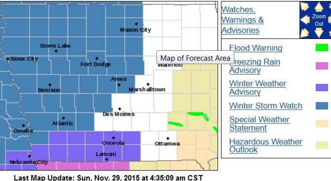
Winter Storm Watch late Sunday night into Monday night (counties in blue). Winter Weather Advisory until 6am Sun. for counties in purple).
For today: Light freezing rain will continue on-and-off across far southeast Nebraska and southwest Iowa this (Sunday) morning. The Main brunt of the storm system will enter the area tonight into Monday and Monday night, bringing a mix of rain…freezing rain…sleet and snow.
The area from Omaha/Council Bluffs to Harlan will see mixed precipitation including icing and /or several inches of snow. Elsewhere in the Winter Storm Watch area, freezing rain will develop later tonight before quickly changing to all snow Monday morning. Additional snowfall and other mixed wintry precipitation of varied intensities will occur later in the day, Monday, before switching to main all lighter snow Monday night or Tuesday.
The National Weather Service predicts anywhere from three-to five-inches of snow will fall in Cass and surrounding Counties, with eight-inches or more further into northwest Iowa. Ice accumulations amounting to several hundredths of an inch may precede the snow.
Winds will shift from the east to southwest Monday, ranging from 5-to 15 miles per hour during the day, with gusts up to 20mph at night. Ice topped by snow will lead to hazardous travel conditions and may possibly impact the Monday morning commute. The heavy, wet snow will also be difficult to shovel and remove.
A WINTER STORM WATCH MEANS THERE IS A POTENTIAL FOR SIGNIFICANT SNOW…SLEET…OR ICE ACCUMULATIONS THAT MAY IMPACT TRAVEL. CONTINUE TO MONITOR THE LATEST FORECASTS.

Podcast: Play in new window | Download (661.4KB)
Subscribe: RSS

Click on the map to enlarge


