
Today: Partly Cloudy & breezy. High near 50. W/SW @ 10-20mph.
Tonight: P/Cldy. Low around 27.
Tuesday: P/Cldy. High near 52. S @ 10-20.
Tuesday Night: Mostly cloudy, with a low around 38.
Wednesday: Mo. Cldy w/patchy fog and drizzle in the morning, otherwise a chance of light rain. High around 50.
Wed. Night: Cldy w/a 70% chance of rain. Low around 39. New precipitation amounts between a tenth and quarter of an inch possible.
Thanksgiving Day: An 80% chance of rain. High near 46.
Sunday’s High in Atlantic was 44. Our 24-hour low ending today at 7-a.m. was 23. Last year on this date we reached 30 for a High and 15 was the low. The All-time Record High in Atlantic on this date was 84 in 1953, while the Record Low was -6 in 1898.
Sunrise is at 7:18-a.m. Sunset is 4:54-p.m.
359 AM CST MON NOV 23 2015
EARLY THIS MORNING…CLEAR. NOT AS COLD. WEST WIND NEAR 10 MPH.
TODAY…SUNNY. HIGH IN THE MID 40S. NORTHWEST WIND NEAR 10 MPH.
TONIGHT…PARTLY CLOUDY. LOW IN THE MID 20S. SOUTHEAST WIND NEAR 10 MPH.
TUESDAY…MOSTLY SUNNY. HIGH IN THE UPPER 40S. SOUTHEAST WIND 10 TO 15 MPH.
WEDNESDAY…CLOUDY. PATCHY FOG IN THE MORNING. A CHANCE OF LIGHT RAIN AND PATCHY DRIZZLE IN THE MORNING…THEN A CHANCE OF LIGHT RAIN AND AREAS OF DRIZZLE IN THE AFTERNOON. HIGH IN THE LOWER 50S. SOUTH WIND 10 TO 15 MPH WITH GUSTS TO AROUND 25 MPH. CHANCE OF RAIN 50 PERCENT.
THANKSGIVING DAY…LIGHT RAIN. HIGH IN THE LOWER 40S. CHANCE OF RAIN 80 PERCENT.
Today: Patchy fog before 7am. Otherwise, sunny, with a high near 40. Southwest wind 5 to 15 mph.
Tonight: Mostly clear, with a low around 23. West wind 5 to 10 mph.
Monday: Mostly sunny, with a high near 42. West wind 5 to 10 mph becoming light and variable in the afternoon.
Monday Night: Patchy fog after 3am. Otherwise, mostly clear, with a low around 27. Light east southeast wind becoming southeast 5 to 10 mph in the evening.
Tuesday: Patchy fog before 9am. Otherwise, mostly sunny, with a high near 46. South southeast wind 10 to 15 mph, with gusts as high as 20 mph.
Tuesday Night: Areas of fog after midnight. Otherwise, mostly cloudy, with a low around 38.
Wednesday: A 30 percent chance of rain. Cloudy, with a high near 52. Breezy.
A deep freeze is setting in across the Midwest with low temperatures forecast in the single digits and a few below zero, turning the season’s first major snow into ice that made some roads treacherous to travel.
After snow on Friday and Saturday across much of the region, temperatures plunged behind the front on Sunday. The National Weather Service forecast 20 degrees or lower across six states from North Dakota to Illinois. Fargo, North Dakota could dip to 11 degrees by early Sunday. Madison, Wisconsin could see 7 degrees, Des Moines 12 and Chicago 9.
Parts of Iowa, northwest Illinois and southern Wisconsin could reach zero or below, the weather service said.
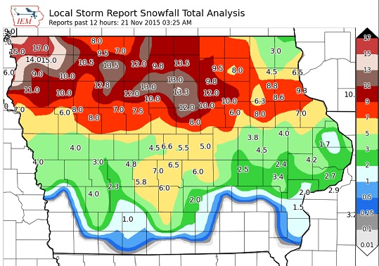
DES MOINES, Iowa (AP) — Iowa residents are digging out from under more than a foot of snow in some places, while roads over all but the southwest portion of the state remain impassable or partially blocked. The National Weather Service says a wintry storm that began dropping snow on the state Friday dumped between 6 and 12 inches overnight on much of Iowa.
Officials say the heaviest snow fell between around Highway 20 in the Cedar Falls and Waterloo areas. Craig Bargfrede with the Iowa Department of Transportation told the Des Moines Register that plow crews worked through the night and were still working Saturday to clear roads.
Temperatures for most of the state will range from 20 to 25 degrees Saturday, with wind chills in the teens and single digits.
Today: Sunny, with a high near 26. Wind chill values as low as 10. North wind 7 to 13 mph becoming west in the afternoon.
Tonight: Increasing clouds, with a low around 15. Wind chill values as low as 5. West wind 5 to 8 mph becoming south in the evening.
Sunday: Sunny, with a high near 40. Wind chill values as low as 5. West southwest wind 6 to 13 mph.
Sunday Night: Mostly clear, with a low around 24. West wind 6 to 11 mph.
Monday: Sunny, with a high near 42. West wind around 6 mph becoming southeast in the afternoon.
Tuesday: Mostly sunny, with a high near 46.
Friday’s High in Atlantic was 40. We received 1.5-inches of snow here at the KJAN studios Friday. The snow-rain mix resulted in a liquid precipitation value of .14″.
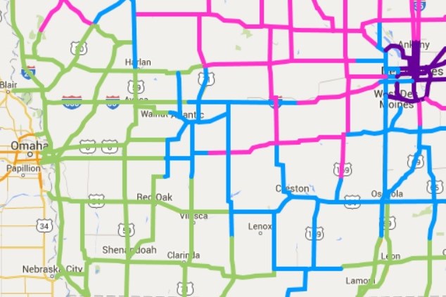
Green: Seasonal travel conditions
Blue: Partially covered with snow (watch out for icy bridges)
Pink: Completely covered with snow, ice or slush. (go to 511.ia.org for the latest info., or call 5-1-1 in Iowa)
A WINTER STORM WARNING REMAINS IN EFFECT FROM 2-PM FRIDAY UNTIL 6 AM SATURDAY FOR AUDUBON-GUTHRIE AND DALLAS COUNTIES; FROM 3-PM FRIDAY THROUGH 3-AM SATURDAY FOR MONONA, HARRISON AND SHELBY COUNTIES, AND FROM 10-AM FRIDAY THROUGH 6-AM SATURDAY FOR SAC-CRAWFORD-AND CARROLL COUNTIES.
* TIMING…SNOW IS EXPECTED TO BEGIN ACROSS THE AREA DURING THE
AFTERNOON HOURS AND MAY HAVE A SIGNIFICANT IMPACT ON THE LATE
AFTERNOON AND EARLY EVENING COMMUTE.
* STORM TOTAL SNOW ACCUMULATIONS…6 TO 10 INCHES POSSIBLE.
* WINDS/VISIBILITIES…VISIBILITIES WILL BE REDUCED TO LESS THAN
ONE HALF MILE AT TIMES IN FALLING SNOW. IN ADDITION…WINDS OF
15 TO 25 MPH MAY PRODUCE MINOR BLOWING AND DRIFTING…AND ALSO
HELP CONTRIBUTE TO REDUCED VISIBILITIES.
* IMPACTS…THE COMBINATION OF SLUSHY AND SNOW COVERED ROADS WILL
LEAD TO HAZARDOUS TRAVEL CONDITIONS…INCLUDING DURING THE
FRIDAY EVENING COMMUTE. TRAVEL CONDITIONS WILL LIKELY BECOME
TREACHEROUS AT TIMES.
MODERATE TO HEAVY SNOW TODAY AND TONIGHT. .THE FIRST WINTER STORM OF THE SEASON WILL IMPACT A LARGE PORTION OF IOWA TODAY AND TONIGHT. SNOW HAS BEGUN ACROSS NORTHWESTERN AND
NORTHERN IOWA AND WILL SPREAD ACROSS THE REMAINDER OF THE AREA
THIS AFTERNOON AND EVENING. BREEZY NORTHERLY WINDS FRIDAY NIGHT MAY CAUSE AREAS OF BLOWING AND DRIFTING OF SNOW.
A WINTER WEATHER ADVISORY REMAINS IN EFFECT FROM 2-PM FRIDAY UNTIL 6 AM CST SATURDAY FOR CASS-ADAIR-ADAMS-UNION COUNTIES, AND FROM 3-PM FRIDAY UNTIL 3-AM SATURDAY FOR POTTAWATTAMIE AND MONTGOMERY COUNTIES.
* TIMING…THE PRECIPITATION IS EXPECTED TO BEGIN AS RAIN BEFORE
TRANSITIONING TO SNOW BY MID TO LATE FRIDAY AFTERNOON THEN
CONTINUE OVERNIGHT. THE SNOW MAY BECOME HEAVY AT TIMES.
* STORM TOTAL SNOW ACCUMULATIONS…3 TO 6 INCHES POSSIBLE.
* WINDS/VISIBILITIES…VISIBILITIES WILL BE REDUCED TO LESS THAN
ONE HALF MILE AT TIMES IN FALLING SNOW. IN ADDITION…WINDS OF
15 TO 25 MPH MAY PRODUCE MINOR BLOWING AND DRIFTING…AND ALSO
HELP CONTRIBUTE TO REDUCED VISIBILITIES.
* IMPACTS…THE COMBINATION OF SLUSHY AND SNOW COVERED ROADS MAY LEAD TO HAZARDOUS TRAVEL CONDITIONS…INCLUDING DURING THE
FRIDAY EVENING COMMUTE. TRAVEL CONDITIONS WILL LIKELY BECOME
HAZARDOUS AT TIMES.
PRECAUTIONARY/PREPAREDNESS ACTIONS…
A WINTER WEATHER ADVISORY FOR SNOW MEANS THAT PERIODS OF SNOW
WILL CAUSE PRIMARILY TRAVEL DIFFICULTIES. BE PREPARED FOR SNOW
COVERED ROADS AND LIMITED VISIBILITIES…AND USE CAUTION WHILE
DRIVING.


