
…WIND ADVISORY IN EFFECT UNTIL 6 PM CST THIS EVENING…
EARLY THIS MORNING…MOSTLY CLOUDY. WINDY. NORTHWEST WIND 25 TO 30 MPH WITH GUSTS TO AROUND 45 MPH.
TODAY…SUNNY…WINDY…COOLER. HIGH AROUND 50. NORTHWEST WIND 20 TO 30 MPH WITH GUSTS TO AROUND 40 MPH.
TONIGHT…CLEAR. LOW IN THE UPPER 20S. WEST WIND 10 TO 15 MPH. GUSTS UP TO 25 MPH THROUGH MIDNIGHT.
FRIDAY…SUNNY. HIGH AROUND 50. WEST WIND 5 TO 15 MPH.
SATURDAY…SUNNY…WARMER. HIGH IN THE LOWER 60S. SOUTHWEST WIND 5 TO 15 MPH WITH GUSTS TO AROUND 25 MPH.
SUNDAY…PARTLY SUNNY. BREEZY. HIGH AROUND 60.
352 AM CST THU NOV 12 2015
STRONG AND GUSTY WINDS CONTINUE TODAY. GUSTY WEST TO NORTHWEST WINDS WILL CONTINUE TODAY IN THE WAKE OF A POWERFUL SYSTEM THAT PASSED ACROSS IOWA ON WEDNESDAY. WIND GUSTS WILL DIMINISH A BIT THIS MORNING BEFORE INCREASING AGAIN LATER TODAY.
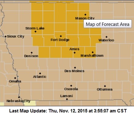
Wind Advisory for counties shaded in light brown; High Wind Warning for counties in gold on this map.
THE HIGH WIND WARNING WAS CANCELLED AND REPLACED WITH A WIND ADVISORY, WHICH IS IN EFFECT UNTIL EARLY THIS EVENING (FROM 11-AM. TODAY UNTIL 4-P.M. FOR MONONA-HARRISON-SHELBY-POTTAWATTAMIE-MILLS-MONTGOMERY-FREMONT- PAGE COUNTIES AND FROM 4-AM TODAY UNTIL 6-PM FOR THE REST OF THE AREA)
* WINDS…SUSTAINED AT 30 TO 35 MPH WITH GUSTS NEAR 50 MPH.
* IMPACTS…THE STRONG WINDS WILL AFFECT TRAVELERS…ESPECIALLY HIGH PROFILE VEHICLES ON NORTH SOUTH ROADS. LOOSE OBJECTS WILL ALSO BE BLOWN AROUND.
PRECAUTIONARY/PREPAREDNESS ACTIONS…
A WIND ADVISORY MEANS THAT SUSTAINED WINDS OF 30 TO 45 MPH ARE EXPECTED. WINDS THIS STRONG CAN MAKE DRIVING DIFFICULT…ESPECIALLY FOR HIGH PROFILE VEHICLES. USE EXTRA CAUTION.
Shelby County Emergency Management Coordinator Bob Seivert said Wednesday, crews were out assessing damage from an apparent tornado crossed over from Pottawattamie into Shelby County, Wednesday afternoon. His preliminary report indicated the damage was minimal, and no injuries had been reported.
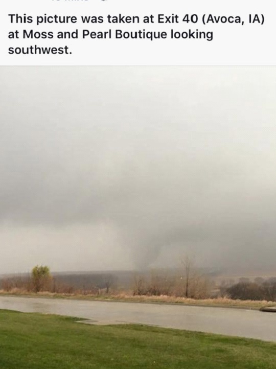
Photo provided by Shelby County EMA
Seivert said some downed power lines were observed at 400th and M-16, and on Juniper Road. Damage to an outbuilding and trees at one rural location, was additionally being investigated. As was the case in Pottawattamie County, Emergency Management personnel called for spotters to be placed into position prior to the storms moving into the area. Just before 2-p.m., the National Weather service issued a Tornado Warning for Shelby County, with reports of a funnel cloud crossing the interstate and strong rotation indicated by radar.
Spotters were placed countywide, and sirens activated for the cities, of Tennant and Harlan. At 2:08-p.m. Seivert says a wind gust at the Harlan airport was clocked at 76 mph and heavy rain was occurring. An Emergency Management spotter reported a tornado on the ground with debris at about the same time. The tornado warning was cancelled at 2:12-p.m. Seivert said “This was a very unusual event for November.”
The National Weather Service in Valley, NE., confirmed,Wednesday an EF-1 Tornado struck about two-miles south and west of Avoca Wednesday afternoon, sometime around 2-p.m. The twister, which was seen on various pictures captured by motorists and residents, had a path about four-miles long, and packed winds of up to 110-miles per hour.
The tornado dissipated about four-miles north of Avoca. It’s strength was based on preliminary information compiled during a damage assessment. Pottawattamie County Emergency Management Coordinator Doug Reed told KJAN News Wednesday evening, that the tornado was primarily in the rural areas, where it took out at least one corn crib, which was blown across a neighboring field, and a power pole.
Reed said the twister next hit an eastbound semi, blowing it across the interstate to the west side and into the ditch. The driver was not injured. It continued north across York Road, and caused the road to be blocked with downed trees and power lines. The twister then entered Shelby County, where it caused some damage to rural outbuildings and grain bins. No injuries were reported.
Reed said “Even though it’s November, we just kind of went through our regular protocol with the severe weather threat today (Wednesday), and had storm spotters and people from the fire/rescue departments already out when the [National] Weather Service told us that things were ramping-up a little bit for areas of our county. [It was] A quick response, organized response by all, and kinda worked out well, and we’re glad it was isolated to kind of rural areas, with minor damage.”
TORNADO WATCH 534 REMAINS IN EFFECT UNTIL 600 PM CST FOR THE
FOLLOWING AREA COUNTIES…
CARROLL AND SAC
TORNADO WATCH CANCELLED FOR ALL OTHER COUNTIES IN THE KJAN LISTENING AREA.
323 PM CST WED NOV 11 2015
TORNADO WATCH 534 REMAINS IN EFFECT UNTIL 600 PM CST FOR THE
FOLLOWING AREA COUNTIES…
CARROLL AND SAC
TORNADO WATCH CANCELLED FOR ALL OTHER COUNTIES IN THE KJAN LISTENING AREA.
316 PM CST WED NOV 11 2015
…THE TORNADO WARNING FOR NORTHEASTERN GUTHRIE COUNTY IS CANCELLED…THE TORNADIC THUNDERSTORM WHICH PROMPTED THE WARNING HAS MOVED OUT OF THE WARNED AREA. THEREFORE THE WARNING HAS BEEN CANCELLED.
A TORNADO WATCH REMAINS IN EFFECT UNTIL 600 PM CST FOR WEST CENTRAL IOWA.
300 PM CST WED NOV 11 2015
THE NATIONAL WEATHER SERVICE IN DES MOINES HAS ISSUED A
* TORNADO WARNING FOR…
NORTHEASTERN GUTHRIE COUNTY IN WEST CENTRAL IOWA…
SOUTHEASTERN GREENE COUNTY IN WEST CENTRAL IOWA…
* UNTIL 330 PM CST
* AT 300 PM CST…A SEVERE THUNDERSTORM CAPABLE OF PRODUCING A
TORNADO WAS LOCATED NEAR LAKE PANORAMA…OR 8 MILES NORTHEAST OF
GUTHRIE CENTER…MOVING NORTHEAST AT 50 MPH.
HAZARD…TORNADO.
SOURCE…RADAR INDICATED ROTATION.
IMPACT…FLYING DEBRIS WILL BE DANGEROUS TO THOSE CAUGHT WITHOUT
SHELTER. MOBILE HOMES WILL BE DAMAGED OR DESTROYED.
DAMAGE TO ROOFS…WINDOWS AND VEHICLES WILL OCCUR. TREE
DAMAGE IS LIKELY.
* THIS TORNADIC THUNDERSTORM WILL REMAIN OVER MAINLY RURAL AREAS OF
NORTHEASTERN GUTHRIE AND SOUTHEASTERN GREENE COUNTIES…INCLUDING
THE FOLLOWING LOCATIONS…SPRINGBROOK STATE PARK…LAKIN SLOUGH
GAME MANAGEMENT AREA…JAMAICA…BAGLEY…YALE AND RIPPEY.
PRECAUTIONARY/PREPAREDNESS ACTIONS…
TAKE COVER NOW! MOVE TO A BASEMENT OR AN INTERIOR ROOM ON THE LOWEST
FLOOR OF A STURDY BUILDING. AVOID WINDOWS. IF YOU ARE OUTDOORS…IN A
MOBILE HOME…OR IN A VEHICLE…MOVE TO THE CLOSEST SUBSTANTIAL
SHELTER AND PROTECT YOURSELF FROM FLYING DEBRIS.
252 PM CST WED NOV 11 2015
…THE SEVERE THUNDERSTORM WARNING FOR UNION AND NORTHEASTERN ADAMS COUNTIES IS CANCELLED…
THE STORMS WHICH PROMPTED THE WARNING HAVE MOVED OUT OF THE WARNED AREA. THEREFORE THE WARNING HAS BEEN CANCELLED. A TORNADO WATCH REMAINS IN EFFECT UNTIL 600 PM CST
246 PM CST WED NOV 11 2015
THE NATIONAL WEATHER SERVICE IN DES MOINES HAS ISSUED A
* SEVERE THUNDERSTORM WARNING FOR…
NORTHERN MADISON COUNTY IN SOUTH CENTRAL IOWA…
NORTHEASTERN GUTHRIE COUNTY IN WEST CENTRAL IOWA…
GREENE COUNTY IN WEST CENTRAL IOWA…
WESTERN BOONE COUNTY IN CENTRAL IOWA…
DALLAS COUNTY IN CENTRAL IOWA…
* UNTIL 330 PM CST
* AT 246 PM CST…SEVERE THUNDERSTORMS WERE LOCATED ALONG A LINE
EXTENDING FROM 8 MILES NORTHWEST OF CARROLL TO 7 MILES SOUTHEAST OF
COON RAPIDS TO 7 MILES WEST OF WINTERSET…MOVING NORTHEAST AT 50
MPH.
HAZARD…60 MPH WIND GUSTS AND QUARTER SIZE HAIL.
SOURCE…RADAR INDICATED.
IMPACT…HAIL DAMAGE TO VEHICLES IS EXPECTED. EXPECT WIND DAMAGE
TO ROOFS…SIDING AND TREES.
* LOCATIONS IMPACTED INCLUDE…
WEST DES MOINES…URBANDALE…CLIVE…WAUKEE…GRIMES…PERRY…
JEFFERSON…ADEL…MADRID…OGDEN…DALLAS CENTER…EARLHAM…
GRANGER…PANORA…DE SOTO…WOODWARD…VAN METER…JORDAN CREEK
TOWN CENTER…LAKE PANORAMA AND REDFIELD.
THIS INCLUDES INTERSTATE 80 BETWEEN MILE MARKERS 99 AND 121.
PRECAUTIONARY/PREPAREDNESS ACTIONS…
PREPARE IMMEDIATELY FOR LARGE HAIL AND DAMAGING WINDS. PEOPLE OUTSIDE
SHOULD MOVE TO A SHELTER…INSIDE A STRONG BUILDING AND AWAY FROM
WINDOWS.


