
154 PM CST WED NOV 11 2015
THE NATIONAL WEATHER SERVICE IN OMAHA HAS ISSUED A
* TORNADO WARNING FOR…
NORTH CENTRAL POTTAWATTAMIE COUNTY IN SOUTHWESTERN IOWA…
SOUTHEASTERN SHELBY COUNTY IN SOUTHWESTERN IOWA…
* UNTIL 230 PM CST
* AT 154 PM CST…A SEVERE THUNDERSTORM CAPABLE OF PRODUCING A
TORNADO WAS LOCATED NEAR AVOCA…OR 19 MILES NORTHWEST OF
ATLANTIC…MOVING NORTHEAST AT 45 MPH.
HAZARD…TORNADO.
SOURCE…RADAR INDICATED ROTATION.
IMPACT…FLYING DEBRIS WILL BE DANGEROUS TO THOSE CAUGHT WITHOUT
SHELTER. MOBILE HOMES WILL BE DAMAGED OR DESTROYED.
DAMAGE TO ROOFS…WINDOWS AND VEHICLES WILL OCCUR. TREE
DAMAGE IS LIKELY.
* THIS DANGEROUS STORM WILL BE NEAR…
HARLAN AROUND 205 PM CST.
OTHER LOCATIONS IMPACTED BY THIS TORNADIC THUNDERSTORM INCLUDE
PRAIRIE ROSE STATE PARK…NISHNA BEND RECREATION AREA AND KIRKMAN.
THIS INCLUDES THE FOLLOWING HIGHWAYS…
HIGHWAY 59 IN IOWA BETWEEN MILE MARKERS 64 AND 73.
INTERSTATE 80 IN IOWA BETWEEN MILE MARKERS 34 AND 43.
PRECAUTIONARY/PREPAREDNESS ACTIONS…
TAKE COVER NOW! MOVE TO A BASEMENT OR AN INTERIOR ROOM ON THE LOWEST
FLOOR OF A STURDY BUILDING. AVOID WINDOWS. IF YOU ARE OUTDOORS…IN A
MOBILE HOME…OR IN A VEHICLE…MOVE TO THE CLOSEST SUBSTANTIAL
SHELTER AND PROTECT YOURSELF FROM FLYING DEBRIS.
POTTAWATTAMIE IA-MONTGOMERY IA-
149 PM CST WED NOV 11 2015
…A SEVERE THUNDERSTORM WARNING REMAINS IN EFFECT UNTIL 215 PM CST FOR EASTERN POTTAWATTAMIE AND NORTHERN MONTGOMERY COUNTIES…AT 148 PM CST…SEVERE THUNDERSTORMS WERE LOCATED ALONG A LINE EXTENDING FROM 4 MILES EAST OF CARSON TO 4 MILES SOUTH OF ELLIOTT… MOVING NORTHEAST AT 50 MPH.
HAZARD…60 MPH WIND GUSTS AND PENNY SIZE HAIL. A 64 MPH WIND GUST
WAS REPORTED WITH POWER POLES DOWN IN RED OAK.
SOURCE…RADAR INDICATED.
IMPACT…EXPECT DAMAGE TO ROOFS…SIDING AND TREES.
LOCATIONS IMPACTED INCLUDE…
ELLIOTT…GRANT AND FARM CREEK PUBLIC WILDLIFE AREA.
THIS INCLUDES THE FOLLOWING HIGHWAYS…
HIGHWAY 59 IN IOWA NEAR MILE MARKER 41.
INTERSTATE 80 IN IOWA NEAR MILE MARKER 48.
PRECAUTIONARY/PREPAREDNESS ACTIONS…
FOR YOUR PROTECTION MOVE TO AN INTERIOR ROOM ON THE LOWEST FLOOR OF A BUILDING.
SEVERE THUNDERSTORM WARNING
NATIONAL WEATHER SERVICE DES MOINES IA
148 PM CST WED NOV 11 2015
THE NATIONAL WEATHER SERVICE IN DES MOINES HAS ISSUED A
* SEVERE THUNDERSTORM WARNING FOR…
CASS COUNTY IN SOUTHWESTERN IOWA…
* UNTIL 230 PM CST
* AT 148 PM CST…A SEVERE THUNDERSTORM WAS LOCATED 5 MILES NORTHWEST OF ELLIOTT…OR 17 MILES SOUTHWEST OF ATLANTIC…MOVING NORTHEAST AT 55 MPH.
HAZARD…60 MPH WIND GUSTS.
SOURCE…TRAINED WEATHER SPOTTERS.
IMPACT…EXPECT DAMAGE TO ROOFS…SIDING AND TREES.
* LOCATIONS IMPACTED INCLUDE…
ATLANTIC…GRISWOLD…ANITA…LEWIS…CUMBERLAND…MARNE…WIOTA…
COLD SPRINGS STATE PARK…ANITA MUNICIPAL AIRPORT…LAKE ANITA
STATE PARK…GRISWOLD PARK AND ATLANTIC MUNICIPAL AIRPORT.
THIS INCLUDES INTERSTATE 80 BETWEEN MILE MARKERS 50 AND 73.
PRECAUTIONARY/PREPAREDNESS ACTIONS…
FOR YOUR PROTECTION MOVE TO AN INTERIOR ROOM ON THE LOWEST FLOOR OF A BUILDING.
BULLETIN - IMMEDIATE BROADCAST REQUESTED
SEVERE THUNDERSTORM WARNING
NATIONAL WEATHER SERVICE OMAHA/VALLEY NEBRASKA
143 PM CST WED NOV 11 2015

THE NATIONAL WEATHER SERVICE IN OMAHA HAS ISSUED A

* SEVERE THUNDERSTORM WARNING FOR...
  EASTERN POTTAWATTAMIE COUNTY IN SOUTHWESTERN IOWA...
  NORTHERN MONTGOMERY COUNTY IN SOUTHWESTERN IOWA...

* UNTIL 215 PM CST

* AT 143 PM CST...SEVERE THUNDERSTORMS WERE LOCATED ALONG A LINE
  EXTENDING FROM 3 MILES EAST OF MACEDONIA TO 4 MILES NORTHEAST OF
  RED OAK...MOVING NORTHEAST AT 50 MPH.

  HAZARD...60 MPH WIND GUSTS AND PENNY SIZE HAIL.

  SOURCE...RADAR INDICATED.

  IMPACT...EXPECT DAMAGE TO ROOFS...SIDING AND TREES.

* LOCATIONS IMPACTED INCLUDE...
  ELLIOTT...GRANT AND FARM CREEK PUBLIC WILDLIFE AREA.

THIS INCLUDES THE FOLLOWING HIGHWAYS...
 HIGHWAY 59 IN IOWA NEAR MILE MARKER 41.
 INTERSTATE 80 IN IOWA NEAR MILE MARKER 48.

PRECAUTIONARY/PREPAREDNESS ACTIONS...

FOR YOUR PROTECTION MOVE TO AN INTERIOR ROOM ON THE LOWEST FLOOR OF A
BUILDING.
1223 PM CST WED NOV 11 2015
…SIGNIFICANT WEATHER ADVISORY FOR EASTERN HARRISON AND WESTERN SHELBY COUNTIES UNTIL 100 PM CST…
AT 1222 PM CST…DOPPLER RADAR WAS TRACKING A STRONG THUNDERSTORM NEAR PERSIA…OR 29 MILES SOUTH OF DENISON…MOVING NORTH AT 35 MPH.
DIME SIZE HAIL AND WINDS IN EXCESS OF 30 MPH WILL BE POSSIBLE WITH
THIS STORM.
LOCATIONS IMPACTED INCLUDE…
EARLING…PERSIA…DEFIANCE…DUNLAP…PANAMA…PORTSMOUTH…
WESTPHALIA…TENNANT…SCHABEN PARK AND MANTENO RECREATION AREA. THIS INCLUDES HIGHWAY 59 IN IOWA NEAR MILE MARKER 89.
A TORNADO WATCH REMAINS IN EFFECT UNTIL 600 PM CST FOR SOUTHWESTERN IOWA.
THE NATIONAL WEATHER SERVICE HAS ISSUED TORNADO WATCH 534 IN
EFFECT UNTIL 6 PM CST THIS EVENING FOR THE FOLLOWING COUNTIES…
DALLAS MADISON RINGGOLD UNION ADAIR ADAMS CASS TAYLOR AUDUBON CARROLL CRAWFORD GREENE GUTHRIE FREMONT HARRISON MILLS MONTGOMERY PAGE POTTAWATTAMIE SHELBY.
PROBABILITY TABLE:
PROB OF 2 OR MORE TORNADOES : 60%
PROB OF 1 OR MORE STRONG /F2-F5/ TORNADOES : 20%
PROB OF 10 OR MORE SEVERE WIND EVENTS : 60%
PROB OF 1 OR MORE WIND EVENTS 75 MPH : 20%
PROB OF 10 OR MORE SEVERE HAIL EVENTS : 30%
PROB OF 1 OR MORE HAIL EVENTS 2 INCHES : 10%
PROB OF 6 OR MORE COMBINED SEVERE HAIL/WIND EVENTS : 60%
MAX HAIL /INCHES/ : 1.5
MAX WIND GUSTS SURFACE /MPH/ : 70
Iowans who still have leaves to rake may soon find they’ve all blown away, as a wide section of the state will be under a High Wind Warning tonight (Wednesday) and into tomorrow (Thursday). Meteorologist Jeff Zogg, at the National Weather Service, says it’ll get more blustery as the day goes on. “We have a very strong storm system that will be lifting northeast into Iowa later today and moving further northeast tonight and the winds will really increase around the back side of this system,” Zogg says, “with surface winds speeds sustained as high as 40 miles per hour, possibly gusting up to 60 miles per hour.”
Iowans need to take precautions, he says, as the winds could be severe. “With strong winds like we’re expecting tonight, people need to secure outdoor objects, things that may blow around easily, trash cans, lawn furniture,” Zogg says. “Also if you’re traveling, high-profile vehicles are especially at risk, just from the surface area they present to the wind. With that strong wind, it can cause issues if you’re driving those kind of vehicles.”
Those winds are just one key element of a massive storm system that’s stretching across much of the central U-S, likely bringing thunderstorms to Iowa this afternoon. “The greatest threat of severe weather later today will be from southwest into southeast and up to central Iowa, the greatest threat being primarily south of Highway 30,” Zogg says. “The primary threat will be strong winds, however, if we get enough sunshine to destabilize, we may see a couple of tornadoes with some of the stronger storms.”
If there’s a silver lining to the cloudy forecast, it’s that snow is unlikely for Iowa. “There is the possibility, as the system lifts out tonight, we may see a brief change over to snow or a rain-snow mix across northwest and north-central Iowa,” Zogg says. “However, by the time it cools off enough, the precipitation will be lifting out, so we don’t expect any kind of accumulation from the snowfall.”
Parts of Kansas, Nebraska and Colorado are under a Blizzard Warning, with several inches of snow expected along with severe winds, likely bringing white-out conditions.
(Radio Iowa)
Today (Veterans Day): Cloudy w/scattered showers & thunderstorms, some may be severe later this afternoon. High near 62. E/SE @ 10-20 mph this morning becoming S/SW this afternoon & gusting up to 25. New rainfall amounts between a half and three quarters of an inch possible.
Tonight: High Wind Warning in effect through early Thursday morning.
Becoming very windy. Showers & thunderstorms ending late. Cloudy to P/Cldy. Low 36. NW @ 20-40mph w/gusts to near 55. New precipitation amounts between a tenth and quarter of an inch, except higher amounts possible in thunderstorms.
Thursday: P/Cldy to Cldy & windy. High near 50. NW @ 20-40.
Thursday Night: Clear & windy. Low around 29. W/NW @ 15-30mph.
Friday: P/Cldy. High near 48. W/NW @ 10-20.
Saturday: P/Cldy & breezy. High near 58.
Tuesday’s High in Atlantic was 60. Our 24-hour Low ending today at 7-a.m., was 37. Last year on this date, the High in Atlantic was 25, and the Low 13. The All-Time Record High in Atlantic on Nov. 11th, was 73 in 1964 & 2005. The Record Low was -10 in 1986.
Early This Morning: Mostly cloudy with scattered light showers. Patchy fog. East wind near 10 mph. Chance of showers 30 percent.
Today: Patchy fog in the morning. Scattered light showers through mid morning…then thunderstorms in the late morning and afternoon. Breezy. Some thunderstorms may be severe in the afternoon. High in the lower 60s. South wind 10 to 20 mph with gusts to around 30 mph. Chance of precipitation 90 percent.
Tonight: HIGH WIND WARNING in effect late this evening until early Thursday morning for most counties along and north of I-80. Mostly cloudy. Rain likely in the evening…then a chance of rain before midnight and early morning. Very windy. Low in the upper 30s. Northwest wind 25 to 40 mph with gusts to around 60 mph. Chance of rain 70 percent.
Thursday: Sunny…windy…cooler. High around 50. Northwest wind 20 to 30 mph with gusts to around 45 mph.
Friday: Sunny. High in the upper 40s. West wind 10 to 15 mph.
Saturday: Sunny. High in the upper 50s.
HARRISON-SHELBY-POTTAWATTAMIE COUNTIES: A HIGH WIND WARNING IN EFFECT FROM 5 PM TODAY UNTIL 3 AM THURSDAY. THE HIGH WIND WATCH IS NO LONGER IN EFFECT FOR THOSE COUNTIES.
AUDUBON-GUTHRIE-DALLAS-POLK-CASS-ADAIR-MADISON COUNTIES: HIGH WIND WARNING FROM 9-PM (WED.) THROUGH 6-AM THURSDAY. WIND ADVISORY FROM 6-AM-TO 6-PM THURSDAY.
SAC-CRAWFORD-CARROLL COUNTIES: HIGH WIND WARNING IN EFFECT UNTIL 6-AM THURSDAY, FOLLOWED BY A WIND ADVISORY FROM 6-AM THURSDAY UNTIL 6-P.M.
MILLS-MONTGOMERY-FREMONT AND PAGE COUNTIES: WIND ADVISORY 5-PM TODAY THROUGH 3-AM THURSDAY.
ADAMS-UNION-TAYLOR AND RINGGOLD COUNTIES: WIND ADVISORY IN EFFECT FROM 9-PM WED. (TODAY) UNTIL 6-AM THURSDAY.
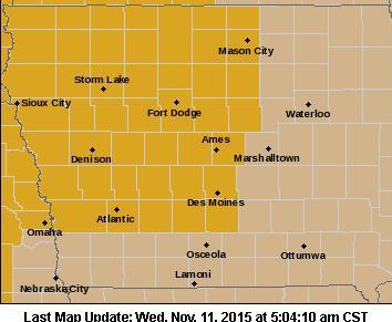
High Wind Warning for counties in gold, Wind Advisory for counties in brown
WINDS OF 35 TO 45 MPH WITH GUSTS OF 55 TO 60 MPH ARE LIKELY. WIND SPEEDS OF THIS MAGNITUDE WILL BE HAZARDOUS TO MOTORISTS, ESPECIALLY THOSE WITH HIGH PROFILE VEHICLES. CERTAIN OUTDOOR ITEMS WHICH CAN BE BLOWN AWAY SHOULD BE SECURED OR BROUGHT INDOORS.
A HIGH WIND WARNING MEANS A HAZARDOUS HIGH WIND EVENT IS EXPECTED OR OCCURRING. SUSTAINED WIND SPEEDS OF AT LEAST 40 MPH OR GUSTS OF 58 MPH OR MORE CAN LEAD TO PROPERTY DAMAGE.


