
The National Weather Service is updating the amount of ice that has accumulated at various communities across the state this morning. Ice generally ranged from .1″ (one-tenth of an inch) to .2″ across parts of west-central and southwest Iowa, to as much as .3″ in eastern Iowa, near Cedar Falls. An additional .1″ to .25″ can be expected across the listening area before the precipitation ends early Tuesday morning.
Atlantic, .1″ (KJAN)
Audubon (1 mile S/SE), .1″
Carroll, .1″
Lorimor, .2″
Mt. Ayr, .25″
The ice storm will continue through much of the day today with the bulk of the freezing rain accrual occurring through around midday. An additional tenth to quarter inch of ice is likely by this afternoon across much of central Iowa. Above freezing temperatures at the surface look to creep into southern Iowa later this morning and mitigate the additional ice amounts. By tonight, light wintry mix is anticipated on the backside of the low pressure system over northern Iowa where light snow/sleet accumulations are possible. Mainly light freezing rain or freezing drizzle can be expected elsewhere with an additional glaze of ice possible. Once this system clears the state late tonight, above normal temperatures return to the state by the end of the week.
Ice-covered tree limbs are snapping across a wide section of Iowa, causing hundreds of power outages. An Ice Storm Warning is posted for much of western and central Iowa, stretching as far east as Waterloo. Meteorologist Brad Small, at the National Weather Service bureau in Johnston, says that layer of ice is making travel very slow-going.
State and local crews are spreading sand, salt and brine on the roads, feverishly working to make those thoroughfares passable, but the elements aren’t cooperating. “Air and road temperatures are hovering right around the freezing mark, plus or minus a degree or two,” Small says. “There will be some melting today but unfortunately, with this additional rain, we could see additional accumulations of ice. Temperatures for highs will only be the mid-30s at best and that’s only over southern Iowa.”
Sometimes, even the road crews get into trouble. Earlier this (Monday) morning, two Adair County snowplows and a County truck spun off White Pole Road into the ditch south of Interstate 80. No injuries were reported.
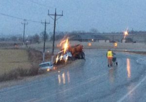
(Photo submitted)
Tuesday morning’s commute should be much better, Small says, as the road crews will have had a full day or more to combat the sheets of ice. “Tomorrow, there could be some minor melting but the good news is, we don’t have any precipitation in the forecast into mid-week,” Small says. “We may actually see highs in the 30s and 40s and possibly even 50 or more by Thursday.”
In southwest Iowa, about 62 customers of the Southwest Iowa Rural Electric Cooperative were without power in Taylor and Ringgold Counties, combined, and minor, scattered outages were reported by Mid-American Energy in Pottawattamie County. The few customers affected in Pott. County had their power restored by 9-a.m. or so. As of 9:30-a.m., Alliant Energy reported 64 customers were affected by an outage in Adair County, 90 in Madison County, and 27 were affected in Union County.
Power outages were worst in the Des Moines metro as MidAmerican Energy reported nearly 24-hundred customers had no electricity earlier today, though the utility say most are now back online.
(Radio Iowa/KJAN)
DES MOINES, Iowa (AP) – A few states in the Midwest again are on alert for icy conditions, while strong storms are moving through the Houston area. While the weekend’s storm caused travel issues in parts of Oklahoma and Kansas, some meteorologists acknowledged it fell short of dire forecasts. Kansas, Nebraska and Iowa are expected to see a mix of rain and freezing rain today (Monday).
Strong storms moved through Houston on Monday morning, following a night of storms. There was at least one tornado in Texas on Sunday evening, and severe weather kept some fans, the Packers and a few Cowboys inside Dallas’ AT&T Stadium for more than hour after the NFL divisional playoff game on Sunday night.
In southwest Iowa, only scattered power outages were reported this morning, due to icing.
Today: **ICE STORM WARNING through late this evening**
Area of fog, periods of freezing rain/drizzle this morning; Rain/drizzle this afternoon. High 34. E/SE @ 10-20.
Tonight: Freezing rain or drizzle changing to light snow. Low 31. NW @ 10-15.
Tomorrow: Cldy to P/Cldy. High 38. NW @ 10-20mph.
Wednesday: P/Cldy High 48.
Thursday: P/Cldy. High near 50.
Sunday’s High in Atlantic was 35. Our Low this morning was 28. We received .2” of an inch of precipitation over the past 24-hours (ending at 7-a.m. today, here in Atlantic. Last year on this date, our High in Atlantic was 20 and the low was -8. The Record High in Atlantic on this date was 64 in 1990. The Record Low was -25 in 2009.
OMAHA, Neb. (AP) – Travel remains hazardous in parts of Iowa and Nebraska as ice storms move north and east through the states. Authorities say most roadways that have been treated in anticipation of sleet or freezing rain are safe for cautious navigation. But untreated sidewalks, streets and rural roads could be treacherous Monday.
Fears of widespread power outages Sunday and early Monday have not materialized. Major utilities in both states report that fewer than 20 customers don’t have electricity. Air travel is problematical. More than 20 Monday departures have been canceled at Omaha’s Eppley Airfield and five at Des Moines International Airport.
National Weather Service meteorologist Josh Boustead says more rain is expected in both states Monday, but the temperature in most spots is hovering above the freezing mark.
OMAHA, Neb. (AP) — Store shelves are running low on ice melt and pantry staples in parts of Nebraska and Iowa as residents prepared for a predicted ice storm. The National Weather Service has issued an ice storm warning for parts of the southeastern corner of Nebraska for late Saturday, extending to Monday morning. Areas from the Iowa-Missouri border on north are under a winter storm watch.
The weather service says light freezing rain is forecast to develop overnight Saturday into Sunday, with the majority of icing expected Sunday through Monday. Ice accumulations of one-quarter to three-quarters of an inch appear likely, making driving dangerous and threatening to bring down tree limbs and power lines.
Authorities have urged residents to gather enough food, water and fuel and to stay indoors during the storm.
Officials with the Shelby County Emergency Management Agency, Saturday, offered some tips on how to keep warm in the event of a power failure during the anticipated ice storm. Operations Officer Jason Wickizer says “Kerosene heaters are only as safe as the people who use them,” meaning “You have open flames, and some intense surface temperatures,” and people need to use common sense.
 Using Kerosene heaters indoors can be a rewarding experience. Many of the heaters out there allow you to view the flame while it is in use. Kerosene heaters can be safely used indoors, and here here are some tips and precautions about using Kerosene heaters indoors:
#1. CARBON MONOXIDE
Kerosene heaters produce Carbon Monoxide, so do gas stoves, candles, oil lamps, etc. Some heaters produce more than others, and the amount of emissions produced by any one heater may vary depending on the heaters condition. So, service your heater, keep it clean, and make sure it is in peak operating condition at all times.
When using a Kerosene heater you do need to provide it with adequate fresh air, investing in a carbon monoxide detector would not be a waste of money. Do Not close yourself up in a single room with a Kerosene heater, keep adjacent rooms, and doors open. If your house is very air tight (newer homes) you need to crack open a window, maybe leave a flue open on your fire place if you have one, this creates a natural draw, continuously circulating fresh air.
There are add on filters available to use on your heater that will reduce it’s emissions.
#2. FIRE HAZZARDS
Kerosene heaters create very high surface temperatures, therefore they need not be too close to items that can be considered combustible such as furniture, drapes, papers, walls, etc. you get the point. Wickizer recommends a good 24″- 36″ clearance all around a convection type heater (the round ones) for safety purposes. Do not set pans of anything on top of your heater unattended that may boil over into your heater. If your heater does not have a drip tray, it is not a bad idea to have a metal pan of some sort to sit it on.
Kerosene is not a volatile fuel, meaning it is not really explosive, it has a relatively high flash point. Kerosene needs a media or heat for combustion. Something soaked in kerosene will readily light easily when a flame is applied, such as a wick, wood, carpet, a chair, rope, etc, a media, something soaked in kerosene will burn easily, now heat, kerosene heated becomes much more volatile, meaning vapors can more easily be ignited, example a heater that has just been put out, and you immediately attempt to relight, it will relight with a poof, as the temperatures there at the wick are at their flash point, make sense. If your heater gets turned off, or goes out, do not attempt to relight for 15-20 min.
#3. DANGER IN MIXING FUELS.
Never use a gasoline can for Kerosene, what ever type of container you use make sure it is clearly marked, and has had only Kerosene in it. It takes very little gasoline mixed with kerosene to create an unpleasant, and dangerous explosion. Be weary of fuel additives, some of these can become dangerous as well if used in improper amounts. Alternative fuels are available, but do your research, make sure they are safe. Wickizer says he uses only K-1 Kerosene in his heaters.
#4. DON’T LET THE CHILDREN GET BURNED, OR YOU EITHER!!!
Kerosene heaters produce very high surface temperatures, many of the newer heaters provide cages to help reduce the risks, but even the cages get very hot, and will burn you. Talk to your children, and keep the heater where it will not be tripped over when in use, keep it out of high traffic areas. Many older heaters do not have safety features, or cages to prevent burns, so again, use common sense.
#5. HEATERS WITH SAFETY’S / WITHOUT SAFETY’S?
There are a lot of people out there collecting, and using vintage heaters. There are risks involved, as back when these heaters were made the manufacturers were not so worried about lawsuits based on human error, they expected their products to be used with common sense. Therefore many of the older heaters are not equipped with anti tip over devices, cages to prevent terrible burns, etc. knock one of them over you will have a fire, touch one of them while in use, you will have a terrible burn. Keep your heater out of danger zones such as high traffic areas, so no one, pets, or children, would be likely to knock it over. Make sure the heater is sitting level, and if it is sitting on a non-flammable surface.
#6 REFUELING
Consider refueling outdoors, this prevents spilling of fuel on your floors, carpet, table, etc. find something that makes refilling easy for you such as siphon pumps, smaller light weight cans w/ flexible hoses, etc. large cumbersome containers can make refilling a chore. You can make a stable roll around cart to sit your heater on if you have one of these heavy models. If you spill fuel, clean up your mess immediately.
#7 STORING FUEL
Keep your fuel in airtight containers, preferably plastic in construction, and try to keep them in an area not subject to dramatic temperature changes. Keep your storage containers out of the sunlight.
#8 DON’T LEAVE A LIT HEATER UNATTENDED
Your home should not be left unattended while the heater is lit. If you are at home, monitor the device, and it it begins to malfunction, you should be able to smell it.
#9 CAN I LEAVE ONE BURNING ALL NIGHT
Yes you can leave a heater burning all night, but here is what you must do…
To summarize: Wickizer says if you use your heater with common sense, take care of it, and keep it in good working order, you can expect many years of good dependable warm service from your heater.
Skyscan Forecast Saturday, January 14, 2017 Richard Garuckas
Today: Partly sunny. High 30. NW @ 5-10.
Tonight: Mostly Cloudy. Low 16. NNE 5-10.
Sunday: Cloudy. High 31. E @ 5-10.
Sunday Night: Cloudy. Sleet and freezing rain developing. Low 28. Ice accumulations up to .25″.
Monday: Cloudy. Freezing rain early changing over to all rain. High 39. Up to an additional .1″ ice accumulations.
Tuesday: Partly sunny. High 36.
Wednesday: Partly Sunny. High 43.

Podcast: Play in new window | Download (319.4KB)
Subscribe: RSS
A massive winter storm system that stretches a thousand miles from the Great Plains to the Mid-Atlantic states threatens to coat a wide section of Iowa with a layer of ice later this weekend. Meteorologist Kurt Kotenberg, at the National Weather Service bureau in metro Des Moines, says most of the state is now under a Winter Storm Watch.
“Confidence is very high right now that we’re going to have that wintery system come in sometime around Sunday afternoon into Monday morning and afternoon,” Kotenberg says. “There’s going to be some notable impacts with this, especially during that Sunday night-to-Monday morning period where we could see freezing rain and ice accumulation of up to a quarter-of-an-inch across central and southern Iowa.”
Since temperatures will be hovering around the freezing mark, much of the precipitation may fall as rain or freezing rain but likely -not- as snow, though parts of northern Iowa (north of Highway 20) may see an inch or so of snow. He predicts ice will cause the most trouble with this storm.
“The most ice will likely be accumulating between midnight and 6 AM or so Monday morning,” Kotenberg says. “Unfortunately, we’re likely going to wake up to icy roadways across Iowa. Temperatures, we’re going to stay near or below freezing during that morning commute and I don’t see it melting off anytime soon.”
Thick ice can build up on tree limbs, causing them to break and fall on power lines, bringing outages. If you have a generator, gas it up, as electric outages could be widespread. The commute to start the week could very well be a mess. “Be prepared now and make sure you’re ready to go Monday morning,” Kotenberg says. “If you do have to head out, be ready for the slippery conditions on the road, slippery sidewalks and plan on taking it easy on the roadways because travel will likely not be pleasant Monday morning.”
On the plus side, winds are forecast to be very light, only five to ten miles an hour, so it’s not likely there will be a lot of galloping, snapping power lines nor will wind chills be extreme.
(Radio Iowa)
Today: Mostly cloudy. High 23. E/NE @ 5-10.
Tonight: Mo. Cldy. Low 13. NE @ 5.
Tomorrow: Mo. Cldy. High 28. Variable breeze @ 5-10mph.
Sunday: **Winter Storm Watch in effect at 6-a.m. Sunday thru Noon Monday** A 50% chance of snow/freezing rain thru early afternoon, then snow & sleet. High 31. E/SE @ 5-10. Snow/sleet accumulation of less than ½” expected.
Sunday Night: Freezing rain mixed at times w/sleet changing to all freezing rain after midnight. Low 27. New precip. between ¼-and 1/2” expected.
Monday: A mix of freezing rain and rain in the morning before becoming all rain. High 38.
Thursday’s High in Atlantic was 23. Our 24-hour Low (ending at 7-a.m. today) was 10. Last year on this date, our High in Atlantic was 41 and the low was 18. The Record High in Atlantic on this date was 62 in 1987. The Record Low was -24 in 1916.


