
HARRISON-SHELBY-POTTAWATTAMIE COUNTIES IN WESTERN IOWA:
611 AM CST TUE JAN 10 2017
WINTER WEATHER ADVISORY FOR LIGHT FREEZING RAIN IN EFFECT UNTIL 10 AM CST TODAY.
* TIMING…RAIN AND FREEZING RAIN WILL SPREAD NORTHEAST ACROSS THE REGION THROUGH 9 OR 10 AM.
* MAIN IMPACT…UNTREATED ROADS AND SIDEWALKS WILL BECOME VERY
SLICK. RAISED SURFACES MAY ACCUMULATE A LIGHT COATING OF ICE
WHERE SURFACE TEMPERATURES ARE BELOW FREEZING.
PRECAUTIONARY/PREPAREDNESS ACTIONS…
A WINTER WEATHER ADVISORY MEANS THAT PERIODS OF FREEZING RAIN
WILL CAUSE TRAVEL DIFFICULTIES. BE PREPARED FOR SLIPPERY ROADS
AND LIMITED VISIBILITIES… AND USE CAUTION WHILE DRIVING.
SOME SLICK SPOTS MAY DEVELOP EARLY THIS MORNING… ALTHOUGH AIR TEMPERATURES WERE AT OR ABOVE FREEZING ALONG THE INTERSTATE 80 CORRIDOR. ROAD TEMPERATURES FROM OVERNIGHT COOLING WERE STILL HOVERING AROUND THE FREEZING MARK.
THIS MAY LEAD TO SCATTERED SLICK SPOTS…ESPECIALLY ON LESS Traveled OR UNTREATED AND ELEVATED SURFACES THROUGH 7-AM. MOTORISTS AND PEDESTRIANS ARE ENCOURAGED TO DRIVE DEFENSIVELY INTO THE EARLY MORNING COMMUTE AS TRAVEL CONDITIONS MAY CHANGE FROM LOCATION TO LOCATION.
MONONA COUNTY: WINTER WEATHER ADVISORY FOR FREEZING RAIN UNTIL 10-A.M. TODAY.
SAC-CRAWFORD-CARROLL-GREENE COUNTIES: WINTER WEATHER ADVISORY FOR A WINTERY MIX OF SNOW…SLEET & FREEZING RAIN IN EFFECT UNTIL 3 PM TODAY.
* TIMING…A WINTRY MIX OF PRECIPITATION IS EXPECTED TO QUICKLY DEVELOP ACROSS THE ADVISORY AREA THIS MORNING BEFORE SWITCHING TO ALL SNOW BY MIDDAY AND ENDING ALTOGETHER BY 3PM OR 4PM.
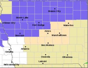
Winter Weather Advisory for counties shaded in purple.
* STORM TOTAL SNOW/ICE ACCUMULATIONS…SNOW ACCUMULATIONS OF AN INCH OR LESS ARE EXPECTED ALONG AND NORTH OF HIGHWAY 20. VERY MINOR SLEET OR ICE ACCUMULATIONS MAY OCCUR IN THE SAME AREA. ANY ICE ACCUMULATIONS WOULD BE NO MORE THAN SEVERAL HUNDREDTHS.
* WINDS/VISIBILITY…WINDS WILL SHARPLY INCREASE WEST TO EAST BETWEEN 10AM AND 2PM. SUSTAINED SPEEDS MAY REACH 25 TO 30 MPH WITH GUSTS TO 40 MPH. THESE WINDS MAY BRIEFLY COINCIDE WITH SNOW PRODUCING LOW VISIBILITIES AND DIFFICULT TRAVEL.
* IMPACTS…ALTHOUGH AMOUNTS WILL BE LIGHT…ROAD TEMPERATURES REMAIN BELOW FREEZING AND LIGHT FREEZING RAIN…SLEET OR SNOW ACCUMULATIONS MAY LEAD TO HAZARDOUS TRAVEL CONDITIONS. BLOWING SNOW MAY ALSO COMPOUND THE SITUATION WITH LIMITED VISIBILITIES.
PRECAUTIONARY/PREPAREDNESS ACTIONS… A WINTER WEATHER ADVISORY MEANS THAT PERIODS OF SNOW, SLEET, OR FREEZING RAIN WILL CAUSE TRAVEL DIFFICULTIES. BE PREPARED FOR SLIPPERY ROADS AND LIMITED VISIBILITIES, AND USE CAUTION WHILE DRIVING.
Early This Morning: Cloudy with a 30 percent chance of light rain. Not as cold. South wind 5 to 10 mph.
Today: Cloudy with light rain likely through mid morning, then cloudy with light rain likely possibly mixed with freezing rain and snow before noon. Mostly sunny in the afternoon. Areas of blowing snow before noon. Breezy. No snow accumulation. A light glazing expected. High in the upper 30s. West wind 10 to 15 mph increasing to 15 to 25 mph in the afternoon. Gusts up to 40 mph. Chance of precipitation 70 percent.
Tonight: Partly cloudy then becoming mostly cloudy before midnight then becoming partly cloudy then becoming mostly cloudy early in the morning. Low in the mid 20s. South wind 5 to 10 mph.
Wednesday: Mostly cloudy. High in the mid 30s. Southeast wind 5 to 10 mph shifting to the north 10 to 15 mph in the afternoon. Gusts up to 25 mph.
Wednesday Night: Mostly cloudy. A 20 percent chance of light snow after midnight. Colder. Low 5 to 10 above. North wind 10 to 15 mph. Gusts up to 25 mph through midnight.
Thursday: Partly sunny. Colder. High in the lower 20s. North wind around 10 mph.
Friday: Cloudy. High 15 to 20.
346 AM CST TUE JAN 10 2017
THE NATIONAL WEATHER SERVICE IN OMAHA/VALLEY HAS ISSUED A WINTER WEATHER ADVISORY FOR FREEZING RAIN…WHICH IS IN EFFECT UNTIL 10 AM CST THIS MORNING FOR MONONA COUNTY.
* TIMING…RAIN AND FREEZING RAIN WILL SPREAD NORTHEAST ACROSS THE REGION AFTER 5 AM AND CONTINUE THROUGH 9 OR 10 AM.
* MAIN IMPACT…UNTREATED ROADWAYS WILL BECOME VERY SLICK AND RAISED SURFACES MAY ACCUMULATE A LIGHT COATING OF ICE WHERE SURFACE TEMPERATURES ARE BELOW FREEZING.
PRECAUTIONARY/PREPAREDNESS ACTIONS…
A WINTER WEATHER ADVISORY MEANS THAT PERIODS OF FREEZING RAIN WILL CAUSE TRAVEL DIFFICULTIES. BE PREPARED FOR SLIPPERY ROADS AND LIMITED VISIBILITIES, AND USE CAUTION WHILE DRIVING.
Today: Partly cloudy to cloudy. High 34. SE @ 10-20.
Tonight: Cloudy w/light rain-freezing rain. Low 32. S @ 10-20.
Tomorrow: Mo. Cldy w/light mixed precip. in the morning changing to light snow. High 36. NW @ 15-25.
Wednesday: Mo. Cldy. High 34.
Thursday: Mo. Cldy w/flurries. High 18.
Sunday’s High in Atlantic was 26. Our 24-Hour Low (ending at 7-a.m. today) was 8. Last year on this date, our High in Atlantic was 10 and the low was -7. The Record High in Atlantic on this date was 58 in 2002. The Record Low was -23 in 1974.
Early this morning: Mostly cloudy. Not as cold. Low 10 to 15. West wind 5 to 10 mph.
Today: Mostly cloudy. High in the lower 30s. South wind 5 to 15 mph.
Tonight: Mostly cloudy. Not as cold. Low in the lower 30s. South wind 10 to 15 mph with gusts to around 25 mph.
Tuesday: Mostly cloudy with a 20 percent chance of drizzle, freezing drizzle, snow and sleet in the morning, then mostly sunny in the afternoon. High in the upper 30s. West wind 10 to 15 mph with gusts to around 25 mph.
Tuesday Night: Partly cloudy. Colder. Low in the lower 20s. Southwest wind 5 to 10 mph.
Wednesday: Mostly cloudy. High in the mid 30s.
Wednesday Night: Mostly cloudy. A 20 percent chance of light snow through midnight. Low 15 to 20.
Thursday: Mostly cloudy. Colder. High in the lower 20s.
Today: Mostly cloudy, with a high near 25. Wind chill values as low as -10. Breezy, with a south southeast wind 8 to 18 mph, with gusts as high as 30 mph.
Tonight: Partly cloudy, with a low around 14. Wind chill values as low as 5. South wind 5 to 11 mph becoming west after midnight.
Monday: Mostly cloudy, with a high near 34. Wind chill values as low as 10. Light and variable wind becoming south southeast 9 to 14 mph in the morning. Winds could gust as high as 22 mph.
Monday Night: A slight chance of drizzle or freezing drizzle between midnight and 5am, then a slight chance of freezing drizzle after 5am. Cloudy, with a low around 28. South wind 8 to 13 mph, with gusts as high as 20 mph.
Tuesday: A slight chance of freezing drizzle and sleet before 9am, then a slight chance of snow between 9am and noon. Partly sunny, with a high near 36. Southwest wind 8 to 15 mph becoming west northwest in the afternoon. Winds could gust as high as 24 mph. Chance of precipitation is 20%.
Tuesday Night: Mostly cloudy, with a low around 18.
Wednesday: Partly sunny, with a high near 30.
Today: Mostly sunny. High near 20. NW @ 5-10.
Tonight: Partly cloudy. Low 3. E @ 5-10.
Tomorrow: Mo. Cldy. High 27. SE @ 10-20.
Sunday night: Mo. Cldy. Low 22.
Monday: P/Sunny. High 33.
Tuesday: Cldy w/a chance of rain. High 37.
Wednesday: P/Sunny. High 28.
Friday’s High in Atlantic was 15. Our 24-Hour Low was -6. Last year on this date, our High in Atlantic was 34 and the low was 32. The Record High in Atlantic on this date was 63 in 2003. The Record Low was -27 in 1912.
Today: Partly to mostly sunny. High near 15. SW @ 5-10.
Tonight: Partly cloudy. Low 2. S @ 5.
Tomorrow: P/Cldy. High 20. Variable breeze @ 5-10.
Sunday: P/Cldy. High 29.
Monday: P/Cldy. High 42.
Thursday’s High in Atlantic was 10. Our 24-Hour Low (ending at 7-a.m. today) was -6. Last year on this date, our High in Atlantic was 33 and the low was 30. The Record High in Atlantic on this date was 56 in 1933. The Record Low was -24 in 1910.


