
Today: **Dense Fog Advisory until 10-a.m.**
Cloudy w/fog & drizzle this morning; Light rain this afternoon. High 44. SE @ 10.
Tonight: Fog with light rain or drizzle. Low 36. SE @ 5-10.
Tomorrow: Cloudy w/light rain or drizzle. High 47. W @ 10-15.
Sunday/Monday: Mostly cloudy. Highs around 42.
Sunday: Mostly Cloudy. High 42.
Thursday’s High in Atlantic was 42. Our 24-hour Low (ending at 7-a.m. today) was 31. We received .02” (two one-hundredths) of an inch of rain over the past 24-hours, at the KJAN studios. Last year on this date, our High in Atlantic was 23 and the low was 15. The Record High in Atlantic on this date was 64 in 1895. The Record Low was -26 in 1962 (which was also the All-Time record Low in Atlantic).
Today: Areas of fog this morning; Partly cloudy to Cloudy. High 44. SE @ 10.
Tonight: Areas of fog; Mostly cloudy. Low 33. SE @ 5.
Tomorrow: Areas of morning fog; Mo. Cldy w/light rain in the afternoon. High 45. E @ 10.
Saturday: Mo. Cldy w/light rain ending in the morning. High 47.
Sunday: Mostly Cloudy. High 42.
Wednesday’s High in Atlantic was 47. Our 24-hour Low (ending at 7-a.m. today) was 26. Last year on this date, our High in Atlantic was 16 and the low was 9. The Record High in Atlantic on this date was 56 in 1895. The Record Low was -38 in 1892 (which was also the All-Time record Low in Atlantic).
We’re several weeks into winter and although it’s been extremely cold and icy at times, many Iowans have yet to see much snow. State Climatologist Harry Hillaker says only a few inches of snow have fallen in areas of central and southern Iowa, which typically receives 10 to 12 inches of snow by this point in the season. “Especially when you get down to the southwest corner of Iowa – places like Red Oak, Clarinda, Shenandoah and even down to Lamoni to the east – they’ve only received about two inches of snow so far this winter season,” Hillaker says.
Most of THAT snow fell in December. Sections of northeast Iowa, meanwhile, have been hit with some heavy snow storms. “Several places – Decorah, Osage, Cresco – that part of the state has received around 20 inches or more of snow, which is actually just barely above normal for that corner of the state,” Hillaker says.
Much of north-central and northeast Iowa has had snow cover since December 10. That snow will finally be melting away with the warmer weather that’s expected through the weekend. Hillaker says if it would’ve been a bit colder earlier this week, the rain and ice storm could’ve buried the state in snow.
“If it would’ve been ideal snow conditions with the amount of moisture we had, we probably would’ve seen roughly three to four inches of snow in northwestern Iowa and up to 10 to 12 inches in the southern part of the state,” Hillaker says.
This winter has been slightly COLDER than normal, but that’s about to change. “December ended about one-half-degree cooler than usual and January, up through the first 17 days of the month, is also one-half-degree below the average for the month,” Hillaker says. “But, we certainly have some very mild weather on the way for the rest of this week and maybe a little bit into next week as well.”
High temperatures for the remainder of the work week are expected to range from the mid-30s in northern Iowa to the upper 40s south.
(Radio Iowa)
Today: Areas of fog this morning; P/Cloudy. High 48. SW @ 10-15.
Tonight: Partly cloudy. Low 32. SW @ 5-10.
Tomorrow: Mo. Cldy. High 42. S @ 10.
Friday: Mo. Cldy w/a chance of light afternoon rain. High 45.
Saturday: Mostly Cloudy w/a chance of morning rain. High around 45.
Tuesday’s High in Atlantic was 32. Our 24-hour Low (ending at 7-a.m. today) was 25. Last year on this date, our High in Atlantic was 15 and the low was -3. The Record High in Atlantic on this date was 61 in 1951. The Record Low was -28 in 1984.
Today: Areas of fog this morning; Cloudy. High 37. NW @ 10-20.
Tonight: Partly cloudy. Low 19.
Tomorrow: Areas of morning fog; P/Cldy. High 48. SW @ 10-15mph.
Thursday: P/Cldy High 48.
Friday: Mostly Cloudy. High near 45.
Monday’s High in Atlantic was 33. Our 24-hour Low (ending at 7-a.m. today) was 30. We received .37” of an inch of precipitation over the past 24-hours, here in Atlantic. Last year on this date, our High in Atlantic was 3 and the low was -8. The Record High in Atlantic on this date was 57 in 1989. The Record Low was -21 in 1984.
Slick sidewalks, parking lots and roadways could remain a problem this morning (Tuesday) as temperatures across the state hover around the freezing point. A slight warmup is expected to arrive tomorrow (Wednesday), but National Weather Service meteorologist Brad Small says that could bring another danger along rivers — ice jams.
“So, as all of this ice that’s accumulated on the grass thaws and releases into the streams and we get a little more melting…the potential for those ice jams will increase,” Small says. There’s little that can be done to prevent ice jams from happening and they can quickly lead to flash flooding.
“The ice just bottles-up, blocks up the flow, and anywhere upstream of that potentially could see flash flooding…you could get water and/or even ice chunks in your yard,” Small says. “You’re pretty much at the mercy of the river.” High temperatures on Wednesday are expected in the upper 30s to near 50. Highs on Thursday are forecast to reach the 40s to low 50s.
(Radio Iowa)
The National Weather Service is updating the amount of ice that has accumulated at various communities across the state this morning. Ice generally ranged from .1″ (one-tenth of an inch) to .2″ across parts of west-central and southwest Iowa, to as much as .3″ in eastern Iowa, near Cedar Falls. An additional .1″ to .25″ can be expected across the listening area before the precipitation ends early Tuesday morning.
Atlantic, .1″ (KJAN)
Audubon (1 mile S/SE), .1″
Carroll, .1″
Lorimor, .2″
Mt. Ayr, .25″
The ice storm will continue through much of the day today with the bulk of the freezing rain accrual occurring through around midday. An additional tenth to quarter inch of ice is likely by this afternoon across much of central Iowa. Above freezing temperatures at the surface look to creep into southern Iowa later this morning and mitigate the additional ice amounts. By tonight, light wintry mix is anticipated on the backside of the low pressure system over northern Iowa where light snow/sleet accumulations are possible. Mainly light freezing rain or freezing drizzle can be expected elsewhere with an additional glaze of ice possible. Once this system clears the state late tonight, above normal temperatures return to the state by the end of the week.
Ice-covered tree limbs are snapping across a wide section of Iowa, causing hundreds of power outages. An Ice Storm Warning is posted for much of western and central Iowa, stretching as far east as Waterloo. Meteorologist Brad Small, at the National Weather Service bureau in Johnston, says that layer of ice is making travel very slow-going.
State and local crews are spreading sand, salt and brine on the roads, feverishly working to make those thoroughfares passable, but the elements aren’t cooperating. “Air and road temperatures are hovering right around the freezing mark, plus or minus a degree or two,” Small says. “There will be some melting today but unfortunately, with this additional rain, we could see additional accumulations of ice. Temperatures for highs will only be the mid-30s at best and that’s only over southern Iowa.”
Sometimes, even the road crews get into trouble. Earlier this (Monday) morning, two Adair County snowplows and a County truck spun off White Pole Road into the ditch south of Interstate 80. No injuries were reported.
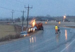
(Photo submitted)
Tuesday morning’s commute should be much better, Small says, as the road crews will have had a full day or more to combat the sheets of ice. “Tomorrow, there could be some minor melting but the good news is, we don’t have any precipitation in the forecast into mid-week,” Small says. “We may actually see highs in the 30s and 40s and possibly even 50 or more by Thursday.”
In southwest Iowa, about 62 customers of the Southwest Iowa Rural Electric Cooperative were without power in Taylor and Ringgold Counties, combined, and minor, scattered outages were reported by Mid-American Energy in Pottawattamie County. The few customers affected in Pott. County had their power restored by 9-a.m. or so. As of 9:30-a.m., Alliant Energy reported 64 customers were affected by an outage in Adair County, 90 in Madison County, and 27 were affected in Union County.
Power outages were worst in the Des Moines metro as MidAmerican Energy reported nearly 24-hundred customers had no electricity earlier today, though the utility say most are now back online.
(Radio Iowa/KJAN)
DES MOINES, Iowa (AP) – A few states in the Midwest again are on alert for icy conditions, while strong storms are moving through the Houston area. While the weekend’s storm caused travel issues in parts of Oklahoma and Kansas, some meteorologists acknowledged it fell short of dire forecasts. Kansas, Nebraska and Iowa are expected to see a mix of rain and freezing rain today (Monday).
Strong storms moved through Houston on Monday morning, following a night of storms. There was at least one tornado in Texas on Sunday evening, and severe weather kept some fans, the Packers and a few Cowboys inside Dallas’ AT&T Stadium for more than hour after the NFL divisional playoff game on Sunday night.
In southwest Iowa, only scattered power outages were reported this morning, due to icing.
Today: **ICE STORM WARNING through late this evening**
Area of fog, periods of freezing rain/drizzle this morning; Rain/drizzle this afternoon. High 34. E/SE @ 10-20.
Tonight: Freezing rain or drizzle changing to light snow. Low 31. NW @ 10-15.
Tomorrow: Cldy to P/Cldy. High 38. NW @ 10-20mph.
Wednesday: P/Cldy High 48.
Thursday: P/Cldy. High near 50.
Sunday’s High in Atlantic was 35. Our Low this morning was 28. We received .2” of an inch of precipitation over the past 24-hours (ending at 7-a.m. today, here in Atlantic. Last year on this date, our High in Atlantic was 20 and the low was -8. The Record High in Atlantic on this date was 64 in 1990. The Record Low was -25 in 2009.


